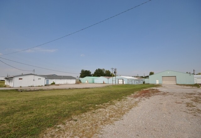
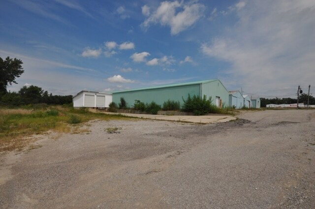
Property Record
3450 E State Road 32, Crawfordsville, IN 47933
Property Detail
3450 E State Road 32
54-07-35-500-015.000-024
PT NEQ 35-19-4 14.489A
Storageyardopenstoragelightequipmentmaterial
Montgomery
B and X Area of moderate flood hazard, usually the area between the limits of the 100-year and 500-year floods.
Indiana
2024
1.32 AC
2025
Indiana North Area
957400
Other Market Areas
11,184 SF
Crawfordsville, IN
NEARBY LISTINGS FOR SALE OR LEASE
-
-
View all Crawfordsville listings for sale on LoopNet.com
DEMOGRAPHICS near 3450 E State Road 32
1 mile
3 mile
5 mile
2024 Total Population
281
8,804
21,528
2029 Population
288
8,993
22,012
Pop Growth 2024-2029
+ 2.49%
+ 2.15%
+ 2.25%
Average Age
44
41
40
2024 Total Households
129
3,857
8,736
HH Growth 2024-2029
+ 2.33%
+ 2.10%
+ 2.31%
Median Household Inc
$52,500
$51,651
$54,992
Avg Household Size
2.10
2.20
2.30
2024 Avg HH Vehicles
2.00
2.00
2.00
Median Home Value
$172,130
$155,391
$161,029
Median Year Built
1971
1966
1964
Nearby Places
Map Layers
Map Styles
 Street
 Aerial
Transit
 Traffic
 Biking
Places
Listings with unknown addresses are not visible on the map
- Restaurants
- Banks
- Shops
- Fitness
- Groceries
PUBLIC TRANSPORTATION
COMMUTER RAIL
Crawfordsville Amtrak (Cardinal - Amtrak)
Drive
Walk
Distance
Crawfordsville Amtrak (Cardinal - Amtrak)
6 min
3.5 mi
Freight Ports
Port of Toledo
Drive
Walk
Distance
Port of Toledo
315 min
260.5 mi
Nearby Properties
Address
Land Use
TOTAL SIZE
Lot Size
Zoning
Address
Land Use
TOTAL SIZE
Lot Size
Zoning
759,225 SF
196.83 AC
Address
Land Use
TOTAL SIZE
Lot Size
Zoning
384,000 SF
24.02 AC
Address
Land Use
TOTAL SIZE
Lot Size
Zoning
119,472 SF
23.23 AC
Address
Land Use
TOTAL SIZE
Lot Size
Zoning
168,100 SF
17.51 AC
Address
Land Use
TOTAL SIZE
Lot Size
Zoning
133,107 SF
7.79 AC
Address
Land Use
TOTAL SIZE
Lot Size
Zoning
12,688 SF
7.38 AC
Address
Land Use
TOTAL SIZE
Lot Size
Zoning
12,688 SF
7.50 AC
Address
Land Use
TOTAL SIZE
Lot Size
Zoning
236,167 SF
64.30 AC
Address
Land Use
TOTAL SIZE
Lot Size
Zoning
184,766 SF
22.50 AC
Address
Land Use
TOTAL SIZE
Lot Size
Zoning
23,550 SF
17.38 AC
Address
Land Use
TOTAL SIZE
Lot Size
Zoning
8,052 SF
14.08 AC
Address
Land Use
TOTAL SIZE
Lot Size
Zoning
100,605 SF
8.01 AC
Address
Land Use
TOTAL SIZE
Lot Size
Zoning
1,900 SF
28.35 AC
Address
Land Use
TOTAL SIZE
Lot Size
Zoning
172,664 SF
13.20 AC
Address
Land Use
TOTAL SIZE
Lot Size
Zoning
5,798 SF
9.45 AC
Address
Land Use
TOTAL SIZE
Lot Size
Zoning
54,501 SF
3.98 AC
Address
Land Use
TOTAL SIZE
Lot Size
Zoning
14,838 SF
8.14 AC
Address
Land Use
TOTAL SIZE
Lot Size
Zoning
45,627 SF
12.50 AC
Address
Land Use
TOTAL SIZE
Lot Size
Zoning
9,644 SF
8.14 AC
Address
Land Use
TOTAL SIZE
Lot Size
Zoning
119,517 SF
8.37 AC
Address
Land Use
TOTAL SIZE
Lot Size
Zoning
7,783 SF
19 AC
Address
Land Use
TOTAL SIZE
Lot Size
Zoning
161,014 SF
7.77 AC
Address
Land Use
TOTAL SIZE
Lot Size
Zoning
35,822 SF
5.73 AC
Address
Land Use
TOTAL SIZE
Lot Size
Zoning
11,736 SF
10 AC
Address
Land Use
TOTAL SIZE
Lot Size
Zoning
13,469 SF
2.72 AC
Address
Land Use
TOTAL SIZE
Lot Size
Zoning
79,925 SF
4.18 AC
Address
Land Use
TOTAL SIZE
Lot Size
Zoning
40,294 SF
18.98 AC
Address
Land Use
TOTAL SIZE
Lot Size
Zoning
42,186 SF
6.69 AC
Address
Land Use
TOTAL SIZE
Lot Size
Zoning
1,944 SF
80 AC
Address
Land Use
TOTAL SIZE
Lot Size
Zoning
7,746 SF
11.97 AC
The World's #1 Commercial Real Estate Marketplace
Connect with us
© 2026 CoStar Group
The information above has been obtained from sources believed reliable. While we do not doubt its accuracy we have not verified it and make no guarantee, warranty or representation about it. It is your responsibility to independently confirm its accuracy and completeness. Any projections, opinions, assumptions, or estimates used are for example only and do not represent the current or future performance of the property. The value of this transaction to you depends on tax and other factors which should be evaluated by your tax, financial, and legal advisors. You and your advisors should conduct a careful, independent investigation of the property to determine to your satisfaction the suitability of the property for your needs.