Property Record
6610 Wesco Way, Houston, TX 77041


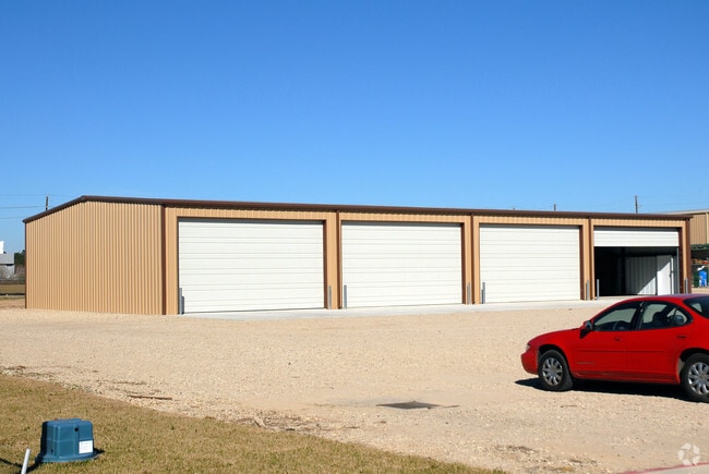
Property Detail
6610 Wesco Way
1294440010002
Emmet Westco
Warehouse
RE A-1 BLK 1 EMMET WESTCO
X
Harris
48201C0630M
Texas
2024
1.70 AC
2025
West Outer Loop
540700
Houston
17,000 SF
Houston-Pasadena-The Woodlands, TX
NEARBY LISTINGS FOR SALE OR LEASE
DEMOGRAPHICS near 6610 Wesco Way
1 mile
3 mile
5 mile
2024 Total Population
9,358
92,181
249,160
2029 Population
9,424
93,170
251,897
Pop Growth 2024-2029
+ 0.71%
+ 1.07%
+ 1.10%
Average Age
38
37
37
2024 Total Households
2,865
33,221
86,560
HH Growth 2024-2029
+ 0.63%
+ 1.09%
+ 1.05%
Median Household Inc
$71,961
$71,516
$75,511
Avg Household Size
3.10
2.70
2.80
2024 Avg HH Vehicles
2.00
2.00
2.00
Median Home Value
$238,279
$237,117
$227,762
Median Year Built
1993
1989
1991
Nearby Places
Map Layers
Map Styles
 Street
 Aerial
Transit
 Traffic
 Biking
Places
Listings with unknown addresses are not visible on the map
- Restaurants
- Banks
- Shops
- Fitness
- Groceries
PUBLIC TRANSPORTATION
AIRPORT
George Bush Intcntl/Houston
Drive
Walk
Distance
George Bush Intcntl/Houston
33 min
24.8 mi
William P Hobby
Drive
Walk
Distance
William P Hobby
52 min
33.3 mi
Freight Ports
Port of Houston
Drive
Walk
Distance
Port of Houston
43 min
28.9 mi
Nearby Properties
Address
Land Use
TOTAL SIZE
Lot Size
Zoning
Address
Land Use
TOTAL SIZE
Lot Size
Zoning
625,701 SF
52.20 AC
Address
Land Use
TOTAL SIZE
Lot Size
Zoning
664,361 SF
39.18 AC
Address
Land Use
TOTAL SIZE
Lot Size
Zoning
380,959 SF
21.43 AC
Address
Land Use
TOTAL SIZE
Lot Size
Zoning
386,642 SF
14.45 AC
Address
Land Use
TOTAL SIZE
Lot Size
Zoning
120.78 AC
Address
Land Use
TOTAL SIZE
Lot Size
Zoning
373,516 SF
18.63 AC
Address
Land Use
TOTAL SIZE
Lot Size
Zoning
358,713 SF
19.91 AC
Address
Land Use
TOTAL SIZE
Lot Size
Zoning
307,698 SF
13.12 AC
Address
Land Use
TOTAL SIZE
Lot Size
Zoning
387,245 SF
18.18 AC
Address
Land Use
TOTAL SIZE
Lot Size
Zoning
408,144 SF
26.13 AC
Address
Land Use
TOTAL SIZE
Lot Size
Zoning
392,185 SF
30.73 AC
Address
Land Use
TOTAL SIZE
Lot Size
Zoning
402,712 SF
25.64 AC
Address
Land Use
TOTAL SIZE
Lot Size
Zoning
463,932 SF
26.62 AC
Address
Land Use
TOTAL SIZE
Lot Size
Zoning
491,051 SF
50 AC
Address
Land Use
TOTAL SIZE
Lot Size
Zoning
388,223 SF
14.99 AC
Address
Land Use
TOTAL SIZE
Lot Size
Zoning
384,280 SF
27.19 AC
Address
Land Use
TOTAL SIZE
Lot Size
Zoning
363,896 SF
21.69 AC
Address
Land Use
TOTAL SIZE
Lot Size
Zoning
412,250 SF
45.79 AC
Address
Land Use
TOTAL SIZE
Lot Size
Zoning
112,440 SF
8.02 AC
Address
Land Use
TOTAL SIZE
Lot Size
Zoning
301,102 SF
12.58 AC
Address
Land Use
TOTAL SIZE
Lot Size
Zoning
327,674 SF
15.32 AC
Address
Land Use
TOTAL SIZE
Lot Size
Zoning
493,233 SF
25.82 AC
Address
Land Use
TOTAL SIZE
Lot Size
Zoning
232,717 SF
10.21 AC
Address
Land Use
TOTAL SIZE
Lot Size
Zoning
292,466 SF
12.18 AC
Address
Land Use
TOTAL SIZE
Lot Size
Zoning
312,939 SF
22.80 AC
Address
Land Use
TOTAL SIZE
Lot Size
Zoning
351,468 SF
16.05 AC
Address
Land Use
TOTAL SIZE
Lot Size
Zoning
324,733 SF
19.26 AC
Address
Land Use
TOTAL SIZE
Lot Size
Zoning
300,292 SF
15.65 AC
Address
Land Use
TOTAL SIZE
Lot Size
Zoning
215,773 SF
15.71 AC
Address
Land Use
TOTAL SIZE
Lot Size
Zoning
300,000 SF
20.07 AC
The World's #1 Commercial Real Estate Marketplace
Connect with us
© 2026 CoStar Group
The information above has been obtained from sources believed reliable. While we do not doubt its accuracy we have not verified it and make no guarantee, warranty or representation about it. It is your responsibility to independently confirm its accuracy and completeness. Any projections, opinions, assumptions, or estimates used are for example only and do not represent the current or future performance of the property. The value of this transaction to you depends on tax and other factors which should be evaluated by your tax, financial, and legal advisors. You and your advisors should conduct a careful, independent investigation of the property to determine to your satisfaction the suitability of the property for your needs.