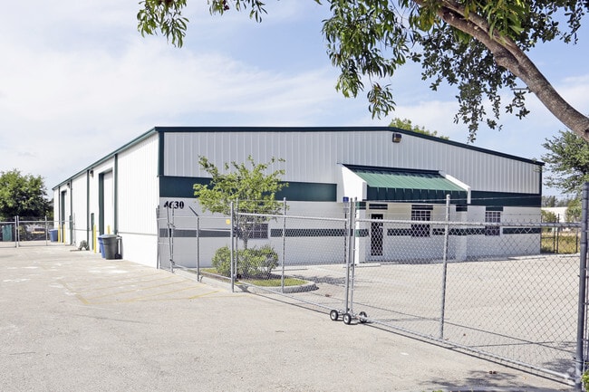
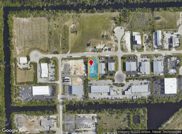
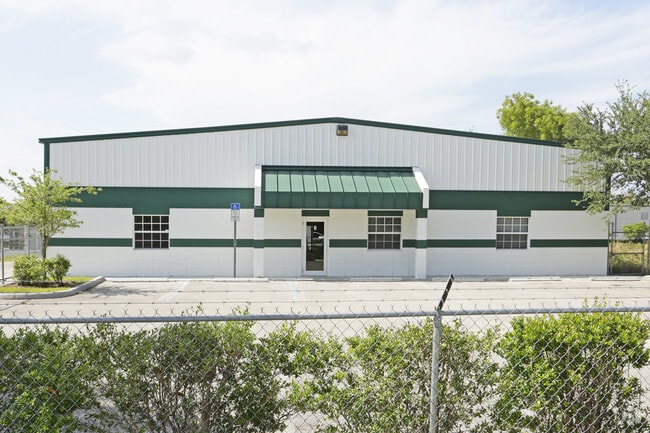
Property Record
4630 Elevation Way, Fort Myers, FL 33905

NEARBY LISTINGS FOR SALE OR LEASE
Property Detail
4630 Elevation Way
Cape Coral-Fort Myers, FL
Benchmark Corporate Park Ph 2
16-44-25-P1-01000.0310
BENCHMARK CORPORATE PARK PH 2 PB 76 PGS 80 + 81 LOT 31
Warehouse
Lee
X
Florida
12071C0289H
31
2024
0.67 AC
2025
City of Ft Myers
000504
Southwest Florida
8,080 SF
DEMOGRAPHICS near 4630 Elevation Way
1 Mile
3 Mile
5 Mile
2024 Total Population
7,297
47,963
118,179
2029 Population
8,599
56,946
140,828
Pop Growth 2024-2029
+ 17.84%
+ 18.73%
+ 19.16%
Average Age
35
38
43
2024 Total Households
2,370
17,019
48,790
HH Growth 2024-2029
+ 17.47%
+ 18.80%
+ 19.06%
Median Household Inc
$35,457
$44,001
$50,674
Avg Household Size
2.90
2.50
2.20
2024 Avg HH Vehicles
1.00
1.00
1.00
Median Home Value
$85,986
$172,759
$238,214
Median Year Built
1978
1987
1992
Nearby Places
Map Layers
Map Styles
 Street
 Aerial
- Restaurants
- Banks
- Shops
- Fitness
- Groceries
PUBLIC TRANSPORTATION
AIRPORT
Southwest Florida International
DRIVE
WALK
Distance
Southwest Florida International
20 min
11.6 mi
Punta Gorda
DRIVE
WALK
Distance
Punta Gorda
36 min
27.2 mi
Nearby Properties
Address
Land Use
TOTAL SIZE
Lot Size
Zoning
Address
Land Use
TOTAL SIZE
Lot Size
Zoning
77.79 AC
PUD
Address
Land Use
TOTAL SIZE
Lot Size
Zoning
4.48 AC
U-CTR
Address
Land Use
TOTAL SIZE
Lot Size
Zoning
438,839 SF
66.95 AC
MU
Address
Land Use
TOTAL SIZE
Lot Size
Zoning
520,572 SF
24.13 AC
CG
Address
Land Use
TOTAL SIZE
Lot Size
Zoning
362,391 SF
12.80 AC
SDA
Address
Land Use
TOTAL SIZE
Lot Size
Zoning
475,045 SF
30.22 AC
PUD
Address
Land Use
TOTAL SIZE
Lot Size
Zoning
723,322 SF
1.73 AC
PUD
Address
Land Use
TOTAL SIZE
Lot Size
Zoning
432,890 SF
18.88 AC
SDA
Address
Land Use
TOTAL SIZE
Lot Size
Zoning
422,099 SF
1.10 AC
CG
Address
Land Use
TOTAL SIZE
Lot Size
Zoning
286,629 SF
13.01 AC
SDA
Address
Land Use
TOTAL SIZE
Lot Size
Zoning
16.13 AC
Address
Land Use
TOTAL SIZE
Lot Size
Zoning
111.70 AC
C1
Address
Land Use
TOTAL SIZE
Lot Size
Zoning
425,658 SF
25.61 AC
CG
Address
Land Use
TOTAL SIZE
Lot Size
Zoning
98,242 SF
17.43 AC
RS-7
Address
Land Use
TOTAL SIZE
Lot Size
Zoning
694,188 SF
22.43 AC
PUD
Address
Land Use
TOTAL SIZE
Lot Size
Zoning
580,121 SF
61.83 AC
IL
Address
Land Use
TOTAL SIZE
Lot Size
Zoning
324,346 SF
20 AC
C1
Address
Land Use
TOTAL SIZE
Lot Size
Zoning
9.07 AC
SDA
Address
Land Use
TOTAL SIZE
Lot Size
Zoning
260,320 SF
8.81 AC
SDA
Address
Land Use
TOTAL SIZE
Lot Size
Zoning
243,841 SF
3.17 AC
CIVIC
Address
Land Use
TOTAL SIZE
Lot Size
Zoning
376,949 SF
49.70 AC
RM16
Address
Land Use
TOTAL SIZE
Lot Size
Zoning
6.99 AC
C-1
Address
Land Use
TOTAL SIZE
Lot Size
Zoning
551,003 SF
3.24 AC
PUD
Address
Land Use
TOTAL SIZE
Lot Size
Zoning
319,765 SF
47.40 AC
RS7
Address
Land Use
TOTAL SIZE
Lot Size
Zoning
107,306 SF
1.91 AC
CIVIC
Address
Land Use
TOTAL SIZE
Lot Size
Zoning
6.38 AC
SDA
Address
Land Use
TOTAL SIZE
Lot Size
Zoning
67.46 AC
C1
Address
Land Use
TOTAL SIZE
Lot Size
Zoning
154,653 SF
11.77 AC
SDA
Address
Land Use
TOTAL SIZE
Lot Size
Zoning
230,967 SF
8.31 AC
SDA
Address
Land Use
TOTAL SIZE
Lot Size
Zoning
482,282 SF
20 AC
CG
The World's #1 Commercial Real Estate Marketplace
Connect with us
© 2025 CoStar Group
The information above has been obtained from sources believed reliable. While we do not doubt its accuracy we have not verified it and make no guarantee, warranty or representation about it. It is your responsibility to independently confirm its accuracy and completeness. Any projections, opinions, assumptions, or estimates used are for example only and do not represent the current or future performance of the property. The value of this transaction to you depends on tax and other factors which should be evaluated by your tax, financial, and legal advisors. You and your advisors should conduct a careful, independent investigation of the property to determine to your satisfaction the suitability of the property for your needs.