Property Record
103 Adams Ln, Oak Ridge, TN 37830
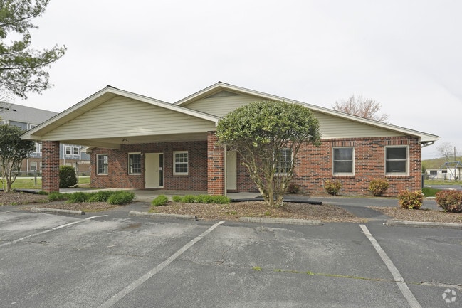

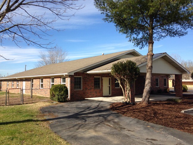

Property Detail
103 Adams Ln
099O-A-011.00
LINDA BROWN PB: 8 PG: 138C
Publichealthcarefacility
Anderson
AE The base floodplain where base flood elevations are provided. AE Zones are now used on new format FIRMs instead of A1-A30 Zones.
Tennessee
2022
1 AC
2025
Anderson County
020500
Knoxville
5,040 SF
Knoxville, TN
NEARBY LISTINGS FOR SALE OR LEASE
DEMOGRAPHICS near 103 Adams Ln
1 mile
3 mile
5 mile
2025 Total Population
5,754
22,917
38,485
2030 Population
6,057
24,151
40,505
Pop Growth 2025-2030
+ 5.27%
+ 5.38%
+ 5.25%
Average Age
38
41
42
2025 Total Households
2,488
9,886
16,332
HH Growth 2025-2030
+ 5.35%
+ 5.51%
+ 5.38%
Median Household Inc
$45,020
$52,339
$61,858
Avg Household Size
2.30
2.30
2.30
2025 Avg HH Vehicles
2.00
2.00
2.00
Median Home Value
$226,080
$237,566
$254,789
Median Year Built
1960
1961
1966
Nearby Places
Map Layers
Map Styles
 Street
 Aerial
Layers
 Traffic
 Biking
Places
Listings with unknown addresses are not visible on the map
- Restaurants
- Banks
- Shops
- Fitness
- Groceries
PUBLIC TRANSPORTATION
AIRPORT
McGhee Tyson
Drive
Walk
Distance
McGhee Tyson
34 min
26.1 mi
Freight Ports
Georgia Ports - Savannah
Drive
Walk
Distance
Georgia Ports - Savannah
504 min
438.6 mi
SALE & LEASE HISTORY
LISTING DATE
SALE/LEASE

Sep 23, 2016
For Sale
Mar 31, 2017
For Sale
Nearby Properties
Address
Land Use
TOTAL SIZE
Lot Size
Zoning
Address
Land Use
TOTAL SIZE
Lot Size
Zoning
11,464.16 AC
Address
Land Use
TOTAL SIZE
Lot Size
Zoning
233,514 SF
10.08 AC
Address
Land Use
TOTAL SIZE
Lot Size
Zoning
413,154 SF
4.10 AC
Address
Land Use
TOTAL SIZE
Lot Size
Zoning
96,668 SF
4.18 AC
Address
Land Use
TOTAL SIZE
Lot Size
Zoning
281,157 SF
31.49 AC
Address
Land Use
TOTAL SIZE
Lot Size
Zoning
137,652 SF
2.93 AC
Address
Land Use
TOTAL SIZE
Lot Size
Zoning
213,356 SF
10.63 AC
Address
Land Use
TOTAL SIZE
Lot Size
Zoning
112,672 SF
18.21 AC
Address
Land Use
TOTAL SIZE
Lot Size
Zoning
39,628 SF
1.06 AC
Address
Land Use
TOTAL SIZE
Lot Size
Zoning
122,401 SF
16.68 AC
Address
Land Use
TOTAL SIZE
Lot Size
Zoning
120,400 SF
4.57 AC
B2
Address
Land Use
TOTAL SIZE
Lot Size
Zoning
108,723 SF
2.19 AC
Address
Land Use
TOTAL SIZE
Lot Size
Zoning
105,513 SF
4.23 AC
Address
Land Use
TOTAL SIZE
Lot Size
Zoning
147,110 SF
11.17 AC
Address
Land Use
TOTAL SIZE
Lot Size
Zoning
162,874 SF
12.98 AC
Address
Land Use
TOTAL SIZE
Lot Size
Zoning
190,966 SF
12.70 AC
R3
Address
Land Use
TOTAL SIZE
Lot Size
Zoning
211,501 SF
15.36 AC
Address
Land Use
TOTAL SIZE
Lot Size
Zoning
413,327 SF
73.64 AC
Address
Land Use
TOTAL SIZE
Lot Size
Zoning
67,780 SF
4.40 AC
IND1
Address
Land Use
TOTAL SIZE
Lot Size
Zoning
36,474 SF
1.90 AC
Address
Land Use
TOTAL SIZE
Lot Size
Zoning
49,728 SF
18.50 AC
Address
Land Use
TOTAL SIZE
Lot Size
Zoning
86,702 SF
8.20 AC
R3
Address
Land Use
TOTAL SIZE
Lot Size
Zoning
34,905 SF
1.59 AC
OF
Address
Land Use
TOTAL SIZE
Lot Size
Zoning
98,832 SF
4.77 AC
Address
Land Use
TOTAL SIZE
Lot Size
Zoning
57,174 SF
6.09 AC
Address
Land Use
TOTAL SIZE
Lot Size
Zoning
53,109 SF
2.60 AC
Address
Land Use
TOTAL SIZE
Lot Size
Zoning
37,903 SF
6.09 AC
OF
Address
Land Use
TOTAL SIZE
Lot Size
Zoning
32,300 SF
4.17 AC
Address
Land Use
TOTAL SIZE
Lot Size
Zoning
76,032 SF
2.38 AC
R3
Address
Land Use
TOTAL SIZE
Lot Size
Zoning
109,185 SF
19.51 AC
The World's #1 Commercial Real Estate Marketplace
Connect with us
© 2026 CoStar Group
The information above has been obtained from sources believed reliable. While we do not doubt its accuracy we have not verified it and make no guarantee, warranty or representation about it. It is your responsibility to independently confirm its accuracy and completeness. Any projections, opinions, assumptions, or estimates used are for example only and do not represent the current or future performance of the property. The value of this transaction to you depends on tax and other factors which should be evaluated by your tax, financial, and legal advisors. You and your advisors should conduct a careful, independent investigation of the property to determine to your satisfaction the suitability of the property for your needs.