Property Record
2066 Central Ave, Schenectady, NY 12304
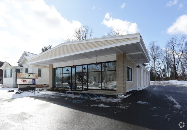

Property Detail
2066 Central Ave
012689-016-004-0005-025-000-0000
N-CENTRAL AV E-2064 S-112-99
Storesoffices
Albany
12
New York
B and X Area of moderate flood hazard, usually the area between the limits of the 100-year and 500-year floods.
25.000
2025
0.50 AC
2025
Central Avenue Corridor
013803
Albany/Schenectady/Troy
3,564 SF
Albany-Schenectady-Troy, NY
NEARBY LISTINGS FOR SALE OR LEASE
DEMOGRAPHICS near 2066 Central Ave
1 mile
3 mile
5 mile
2024 Total Population
4,498
37,273
137,853
2029 Population
4,566
37,781
139,898
Pop Growth 2024-2029
+ 1.51%
+ 1.36%
+ 1.48%
Average Age
44
44
41
2024 Total Households
1,952
15,139
53,592
HH Growth 2024-2029
+ 1.54%
+ 1.37%
+ 1.64%
Median Household Inc
$81,782
$97,401
$87,812
Avg Household Size
2.20
2.40
2.40
2024 Avg HH Vehicles
2.00
2.00
2.00
Median Home Value
$280,417
$298,581
$280,199
Median Year Built
1969
1969
1964
Nearby Places
Map Layers
Map Styles
 Street
 Aerial
Transit
 Traffic
 Biking
Places
Listings with unknown addresses are not visible on the map
- Restaurants
- Banks
- Shops
- Fitness
- Groceries
PUBLIC TRANSPORTATION
AIRPORT
Albany International
Drive
Walk
Distance
Albany International
15 min
6.7 mi
Nearby Properties
Address
Land Use
TOTAL SIZE
Lot Size
Zoning
Address
Land Use
TOTAL SIZE
Lot Size
Zoning
11,700 SF
43.80 AC
R2
Address
Land Use
TOTAL SIZE
Lot Size
Zoning
102,862 SF
32.45 AC
CS
Address
Land Use
TOTAL SIZE
Lot Size
Zoning
242,658 SF
29 AC
19
Address
Land Use
TOTAL SIZE
Lot Size
Zoning
120,755 SF
33.88 AC
R1
Address
Land Use
TOTAL SIZE
Lot Size
Zoning
98.20 AC
LC
Address
Land Use
TOTAL SIZE
Lot Size
Zoning
80.10 AC
LC
Address
Land Use
TOTAL SIZE
Lot Size
Zoning
266,600 SF
22.60 AC
47
Address
Land Use
TOTAL SIZE
Lot Size
Zoning
167,222 SF
15.65 AC
14
Address
Land Use
TOTAL SIZE
Lot Size
Zoning
67,526 SF
9.40 AC
R1
Address
Land Use
TOTAL SIZE
Lot Size
Zoning
103.30 AC
LC
Address
Land Use
TOTAL SIZE
Lot Size
Zoning
4,680 SF
11.39 AC
CH
Address
Land Use
TOTAL SIZE
Lot Size
Zoning
78,326 SF
27.47 AC
R40
Address
Land Use
TOTAL SIZE
Lot Size
Zoning
214,716 SF
28.40 AC
19
Address
Land Use
TOTAL SIZE
Lot Size
Zoning
9,774 SF
49.20 AC
43
Address
Land Use
TOTAL SIZE
Lot Size
Zoning
135,155 SF
6.43 AC
03 - MULTI
Address
Land Use
TOTAL SIZE
Lot Size
Zoning
25,112 SF
13.16 AC
04 - FARM
Address
Land Use
TOTAL SIZE
Lot Size
Zoning
Address
Land Use
TOTAL SIZE
Lot Size
Zoning
79,041 SF
13.20 AC
CN
Address
Land Use
TOTAL SIZE
Lot Size
Zoning
120,373 SF
9.68 AC
CS
Address
Land Use
TOTAL SIZE
Lot Size
Zoning
99,620 SF
15 AC
45
Address
Land Use
TOTAL SIZE
Lot Size
Zoning
117 AC
06 - INDUS
Address
Land Use
TOTAL SIZE
Lot Size
Zoning
68,080 SF
6.22 AC
CS
Address
Land Use
TOTAL SIZE
Lot Size
Zoning
144,030 SF
19.70 AC
19
Address
Land Use
TOTAL SIZE
Lot Size
Zoning
6,889 SF
284.30 AC
F
Address
Land Use
TOTAL SIZE
Lot Size
Zoning
30.20 AC
LC
Address
Land Use
TOTAL SIZE
Lot Size
Zoning
63,762 SF
4 AC
R1
Address
Land Use
TOTAL SIZE
Lot Size
Zoning
89,589 SF
17.40 AC
45
Address
Land Use
TOTAL SIZE
Lot Size
Zoning
167,930 SF
9.36 AC
05 - COMME
Address
Land Use
TOTAL SIZE
Lot Size
Zoning
6,944 SF
13.02 AC
R3
Address
Land Use
TOTAL SIZE
Lot Size
Zoning
83,800 SF
3.84 AC
14
The World's #1 Commercial Real Estate Marketplace
Connect with us
© 2026 CoStar Group
The information above has been obtained from sources believed reliable. While we do not doubt its accuracy we have not verified it and make no guarantee, warranty or representation about it. It is your responsibility to independently confirm its accuracy and completeness. Any projections, opinions, assumptions, or estimates used are for example only and do not represent the current or future performance of the property. The value of this transaction to you depends on tax and other factors which should be evaluated by your tax, financial, and legal advisors. You and your advisors should conduct a careful, independent investigation of the property to determine to your satisfaction the suitability of the property for your needs.