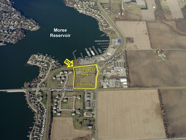
Property Record
20901 Hague Rd, Noblesville, IN 46062


Property Detail
20901 Hague Rd
Indianapolis-Carmel-Greenwood, IN
ACREAGE 4.54, SECTION 13, TOWNSHIP 19, RANGE 4
29-06-13-000-022.001-013
Hamilton
Commercialnec
Indiana
2024
4.54 AC
2025
Far North Hamilton Cnty
110509
Indianapolis
39,962 SF
NEARBY LISTINGS FOR SALE OR LEASE
-
-
View all Noblesville listings for sale on LoopNet.com
DEMOGRAPHICS near 20901 Hague Rd
1 mile
3 mile
5 mile
2024 Total Population
2,703
30,970
64,358
2029 Population
2,867
33,109
69,195
Pop Growth 2024-2029
+ 6.07%
+ 6.91%
+ 7.52%
Average Age
45
41
40
2024 Total Households
1,032
11,749
24,393
HH Growth 2024-2029
+ 6.20%
+ 7.08%
+ 7.67%
Median Household Inc
$127,857
$112,186
$106,343
Avg Household Size
2.60
2.60
2.60
2024 Avg HH Vehicles
3.00
2.00
2.00
Median Home Value
$455,961
$373,515
$364,195
Median Year Built
1990
1994
1996
Nearby Places
Map Layers
Map Styles
 Street
 Aerial
Transit
 Traffic
 Biking
Places
Listings with unknown addresses are not visible on the map
- Restaurants
- Banks
- Shops
- Fitness
- Groceries
PUBLIC TRANSPORTATION
AIRPORT
Indianapolis International
Drive
Walk
Distance
Indianapolis International
66 min
41.8 mi
Freight Ports
Port of Toledo
Drive
Walk
Distance
Port of Toledo
255 min
203.5 mi
SALE & LEASE HISTORY
LISTING DATE
SALE/LEASE

Jun 07, 2017
For Sale
Apr 12, 2017
For Lease
Nearby Properties
Address
Land Use
TOTAL SIZE
Lot Size
Zoning
Address
Land Use
TOTAL SIZE
Lot Size
Zoning
346,059 SF
7.88 AC
Address
Land Use
TOTAL SIZE
Lot Size
Zoning
317,049 SF
38.45 AC
Address
Land Use
TOTAL SIZE
Lot Size
Zoning
451,226 SF
30.53 AC
Address
Land Use
TOTAL SIZE
Lot Size
Zoning
214,828 SF
21.10 AC
Address
Land Use
TOTAL SIZE
Lot Size
Zoning
89,173 SF
5 AC
Address
Land Use
TOTAL SIZE
Lot Size
Zoning
121,077 SF
9.32 AC
Address
Land Use
TOTAL SIZE
Lot Size
Zoning
102,021 SF
28.66 AC
Address
Land Use
TOTAL SIZE
Lot Size
Zoning
99,590 SF
8.50 AC
Address
Land Use
TOTAL SIZE
Lot Size
Zoning
103,216 SF
6.99 AC
Address
Land Use
TOTAL SIZE
Lot Size
Zoning
80,303 SF
12.56 AC
Address
Land Use
TOTAL SIZE
Lot Size
Zoning
105,184 SF
12.69 AC
Address
Land Use
TOTAL SIZE
Lot Size
Zoning
41,016 SF
3.64 AC
Address
Land Use
TOTAL SIZE
Lot Size
Zoning
100,824 SF
7.61 AC
Address
Land Use
TOTAL SIZE
Lot Size
Zoning
41,472 SF
2.96 AC
Address
Land Use
TOTAL SIZE
Lot Size
Zoning
41,472 SF
2.17 AC
Address
Land Use
TOTAL SIZE
Lot Size
Zoning
50,398 SF
3.47 AC
Address
Land Use
TOTAL SIZE
Lot Size
Zoning
49,338 SF
4 AC
Address
Land Use
TOTAL SIZE
Lot Size
Zoning
49,244 SF
3.76 AC
Address
Land Use
TOTAL SIZE
Lot Size
Zoning
45,935 SF
2.75 AC
Address
Land Use
TOTAL SIZE
Lot Size
Zoning
35,825 SF
19.35 AC
Address
Land Use
TOTAL SIZE
Lot Size
Zoning
77,894 SF
1.56 AC
Address
Land Use
TOTAL SIZE
Lot Size
Zoning
29,150 SF
9.46 AC
Address
Land Use
TOTAL SIZE
Lot Size
Zoning
33,846 SF
2.30 AC
Address
Land Use
TOTAL SIZE
Lot Size
Zoning
12,029 SF
36.20 AC
Address
Land Use
TOTAL SIZE
Lot Size
Zoning
12,406 SF
5 AC
Address
Land Use
TOTAL SIZE
Lot Size
Zoning
45,646 SF
8.53 AC
Address
Land Use
TOTAL SIZE
Lot Size
Zoning
48,000 SF
20 AC
Address
Land Use
TOTAL SIZE
Lot Size
Zoning
13,351 SF
2.08 AC
Address
Land Use
TOTAL SIZE
Lot Size
Zoning
35,980 SF
5.05 AC
Address
Land Use
TOTAL SIZE
Lot Size
Zoning
1,560 SF
8.20 AC
The World's #1 Commercial Real Estate Marketplace
Connect with us
© 2026 CoStar Group
The information above has been obtained from sources believed reliable. While we do not doubt its accuracy we have not verified it and make no guarantee, warranty or representation about it. It is your responsibility to independently confirm its accuracy and completeness. Any projections, opinions, assumptions, or estimates used are for example only and do not represent the current or future performance of the property. The value of this transaction to you depends on tax and other factors which should be evaluated by your tax, financial, and legal advisors. You and your advisors should conduct a careful, independent investigation of the property to determine to your satisfaction the suitability of the property for your needs.