Property Record
175 Mcdaniels Rd, Shelbyville, KY 40065


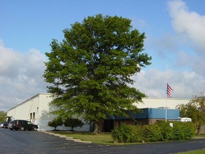
Property Detail
175 Mcdaniels Rd
Louisville/Jefferson County, KY-IN
INDUSTRIAL PARK 22.25 AC & BLDG
041-00-016
Shelby
Commercialnec
Kentucky
B and X Area of moderate flood hazard, usually the area between the limits of the 100-year and 500-year floods.
22.25 AC
2025
Shelby County
2025
Louisville
040404
NEARBY LISTINGS FOR SALE OR LEASE
DEMOGRAPHICS near 175 Mcdaniels Rd
1 mile
3 mile
5 mile
2025 Total Population
3,776
20,851
30,208
2030 Population
3,941
21,774
31,501
Pop Growth 2025-2030
+ 4.37%
+ 4.43%
+ 4.28%
Average Age
34
37
38
2025 Total Households
1,412
7,860
11,402
HH Growth 2025-2030
+ 4.82%
+ 4.57%
+ 4.38%
Median Household Inc
$56,034
$69,396
$75,274
Avg Household Size
2.60
2.60
2.60
2025 Avg HH Vehicles
2.00
2.00
2.00
Median Home Value
$238,589
$273,643
$271,030
Median Year Built
1993
1993
1992
Nearby Places
Map Layers
Map Styles
 Street
 Aerial
Layers
 Traffic
 Biking
Places
Listings with unknown addresses are not visible on the map
- Restaurants
- Banks
- Shops
- Fitness
- Groceries
PUBLIC TRANSPORTATION
AIRPORT
Louisville Muhammad Ali International
Drive
Walk
Distance
Louisville Muhammad Ali International
45 min
32.1 mi
Nearby Properties
Address
Land Use
TOTAL SIZE
Lot Size
Zoning
Address
Land Use
TOTAL SIZE
Lot Size
Zoning
113.65 AC
RESIDENTIA
Address
Land Use
TOTAL SIZE
Lot Size
Zoning
27.16 AC
Address
Land Use
TOTAL SIZE
Lot Size
Zoning
0.49 AC
Address
Land Use
TOTAL SIZE
Lot Size
Zoning
835,454 SF
82.23 AC
Address
Land Use
TOTAL SIZE
Lot Size
Zoning
Address
Land Use
TOTAL SIZE
Lot Size
Zoning
17.53 AC
COM
Address
Land Use
TOTAL SIZE
Lot Size
Zoning
7.94 AC
Address
Land Use
TOTAL SIZE
Lot Size
Zoning
Address
Land Use
TOTAL SIZE
Lot Size
Zoning
186,008 SF
65.43 AC
Address
Land Use
TOTAL SIZE
Lot Size
Zoning
Address
Land Use
TOTAL SIZE
Lot Size
Zoning
17.34 AC
RESIDENTIA
Address
Land Use
TOTAL SIZE
Lot Size
Zoning
18.69 AC
Address
Land Use
TOTAL SIZE
Lot Size
Zoning
24.05 AC
COMMERCIAL
Address
Land Use
TOTAL SIZE
Lot Size
Zoning
Address
Land Use
TOTAL SIZE
Lot Size
Zoning
18.79 AC
RESIDENTIA
Address
Land Use
TOTAL SIZE
Lot Size
Zoning
134,580 SF
22.58 AC
Address
Land Use
TOTAL SIZE
Lot Size
Zoning
Address
Land Use
TOTAL SIZE
Lot Size
Zoning
4.76 AC
COMMERCIAL
Address
Land Use
TOTAL SIZE
Lot Size
Zoning
11.80 AC
COMMERCIAL
Address
Land Use
TOTAL SIZE
Lot Size
Zoning
Address
Land Use
TOTAL SIZE
Lot Size
Zoning
257,160 SF
34.85 AC
Address
Land Use
TOTAL SIZE
Lot Size
Zoning
9.89 AC
Address
Land Use
TOTAL SIZE
Lot Size
Zoning
Address
Land Use
TOTAL SIZE
Lot Size
Zoning
47,700 SF
4.21 AC
Address
Land Use
TOTAL SIZE
Lot Size
Zoning
2.80 AC
Address
Land Use
TOTAL SIZE
Lot Size
Zoning
Address
Land Use
TOTAL SIZE
Lot Size
Zoning
43,161 SF
2.18 AC
RESIDENTIA
Address
Land Use
TOTAL SIZE
Lot Size
Zoning
2.06 AC
COMMERCIAL
Address
Land Use
TOTAL SIZE
Lot Size
Zoning
64.20 AC
RES
Address
Land Use
TOTAL SIZE
Lot Size
Zoning
The World's #1 Commercial Real Estate Marketplace
Connect with us
© 2026 CoStar Group
The information above has been obtained from sources believed reliable. While we do not doubt its accuracy we have not verified it and make no guarantee, warranty or representation about it. It is your responsibility to independently confirm its accuracy and completeness. Any projections, opinions, assumptions, or estimates used are for example only and do not represent the current or future performance of the property. The value of this transaction to you depends on tax and other factors which should be evaluated by your tax, financial, and legal advisors. You and your advisors should conduct a careful, independent investigation of the property to determine to your satisfaction the suitability of the property for your needs.