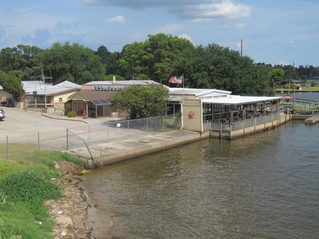
Property Record
10614 Fm 1960, Huffman, TX 77336


Save to a Folder
{{folder.Name}}
{{folder.ListingIds.length}} Properties
{{folder.ListingIds.length}} Property
Create a New Folder
Property Detail
10614 Fm 1960
0360050010013
TR C BLK 1 TROTT G A
Storebuilding
HARRIS
AE The base floodplain where base flood elevations are provided. AE Zones are now used on new format FIRMs instead of A1-A30 Zones.
Texas
2025
1.65 AC
2025
Lake Houston
251702
Houston
1,040 SF
Houston-Pasadena-The Woodlands, TX
NEARBY LISTINGS FOR SALE OR LEASE
DEMOGRAPHICS near 10614 Fm 1960
1 mile
3 mile
5 mile
2025 Total Population
3,327
29,787
99,191
2030 Population
3,627
31,778
105,970
Pop Growth 2025-2030
+ 9.02%
+ 6.68%
+ 6.83%
Average Age
38
40
39
2025 Total Households
1,150
10,495
34,169
HH Growth 2025-2030
+ 9.22%
+ 6.76%
+ 7.01%
Median Household Inc
$64,815
$93,105
$112,197
Avg Household Size
2.80
2.80
2.90
2025 Avg HH Vehicles
2.00
2.00
2.00
Median Home Value
$290,384
$341,800
$339,280
Median Year Built
2001
1996
1998
Nearby Places
Map Layers
Map Styles
 Street
 Aerial
Layers
 Traffic
 Biking
Places
Listings with unknown addresses are not visible on the map
- Restaurants
- Banks
- Shops
- Fitness
- Groceries
PUBLIC TRANSPORTATION
AIRPORT
George Bush Intcntl/Houston
Drive
Walk
Distance
George Bush Intcntl/Houston
28 min
18.1 mi
William P Hobby
Drive
Walk
Distance
William P Hobby
56 min
34.8 mi
Freight Ports
Port of Houston
Drive
Walk
Distance
Port of Houston
43 min
26.8 mi
SALE & LEASE HISTORY
LISTING DATE
SALE/LEASE

Sep 23, 2016
For Sale
Oct 03, 2016
For Sale
Jun 03, 2019
For Sale
Jul 28, 2017
For Lease
Jul 20, 2017
For Sale
Nearby Properties
Address
Land Use
TOTAL SIZE
Lot Size
Zoning
Address
Land Use
TOTAL SIZE
Lot Size
Zoning
203,282 SF
15.53 AC
Address
Land Use
TOTAL SIZE
Lot Size
Zoning
196,633 SF
12.69 AC
Address
Land Use
TOTAL SIZE
Lot Size
Zoning
160,038 SF
8.96 AC
Address
Land Use
TOTAL SIZE
Lot Size
Zoning
158,660 SF
6.08 AC
Address
Land Use
TOTAL SIZE
Lot Size
Zoning
56,172 SF
5.49 AC
Address
Land Use
TOTAL SIZE
Lot Size
Zoning
184,199 SF
14.27 AC
Address
Land Use
TOTAL SIZE
Lot Size
Zoning
45,624 SF
3.95 AC
Address
Land Use
TOTAL SIZE
Lot Size
Zoning
64,600 SF
6.32 AC
Address
Land Use
TOTAL SIZE
Lot Size
Zoning
58,784 SF
4 AC
Address
Land Use
TOTAL SIZE
Lot Size
Zoning
79.87 AC
Address
Land Use
TOTAL SIZE
Lot Size
Zoning
39,921 SF
3.42 AC
Address
Land Use
TOTAL SIZE
Lot Size
Zoning
67,311 SF
5.90 AC
Address
Land Use
TOTAL SIZE
Lot Size
Zoning
16,020 SF
14.47 AC
Address
Land Use
TOTAL SIZE
Lot Size
Zoning
146,352 SF
5.41 AC
Address
Land Use
TOTAL SIZE
Lot Size
Zoning
32,056 SF
4.92 AC
Address
Land Use
TOTAL SIZE
Lot Size
Zoning
9,542 SF
39.75 AC
Address
Land Use
TOTAL SIZE
Lot Size
Zoning
51,796 SF
5.22 AC
Address
Land Use
TOTAL SIZE
Lot Size
Zoning
68,156 SF
2 AC
Address
Land Use
TOTAL SIZE
Lot Size
Zoning
17,351 SF
26 AC
Address
Land Use
TOTAL SIZE
Lot Size
Zoning
15,477 SF
3.65 AC
Address
Land Use
TOTAL SIZE
Lot Size
Zoning
25,064 SF
5.46 AC
Address
Land Use
TOTAL SIZE
Lot Size
Zoning
23,100 SF
1.21 AC
Address
Land Use
TOTAL SIZE
Lot Size
Zoning
48,473 SF
2.82 AC
Address
Land Use
TOTAL SIZE
Lot Size
Zoning
22,171 SF
2.05 AC
Address
Land Use
TOTAL SIZE
Lot Size
Zoning
14,200 SF
11.98 AC
Address
Land Use
TOTAL SIZE
Lot Size
Zoning
57,352 SF
12.44 AC
Address
Land Use
TOTAL SIZE
Lot Size
Zoning
15,600 SF
2.82 AC
Address
Land Use
TOTAL SIZE
Lot Size
Zoning
237.60 AC
Address
Land Use
TOTAL SIZE
Lot Size
Zoning
38,764 SF
2.76 AC
Address
Land Use
TOTAL SIZE
Lot Size
Zoning
41,803 SF
2.55 AC
The World's #1 Commercial Real Estate Marketplace
Connect with us
© 2026 CoStar Group
The information above has been obtained from sources believed reliable. While we do not doubt its accuracy we have not verified it and make no guarantee, warranty or representation about it. It is your responsibility to independently confirm its accuracy and completeness. Any projections, opinions, assumptions, or estimates used are for example only and do not represent the current or future performance of the property. The value of this transaction to you depends on tax and other factors which should be evaluated by your tax, financial, and legal advisors. You and your advisors should conduct a careful, independent investigation of the property to determine to your satisfaction the suitability of the property for your needs.