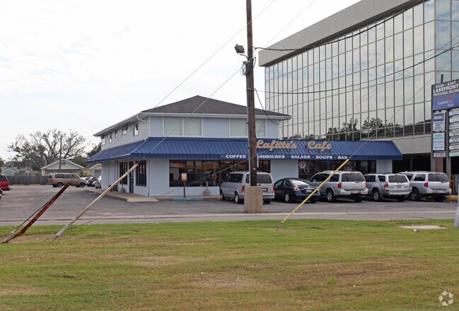
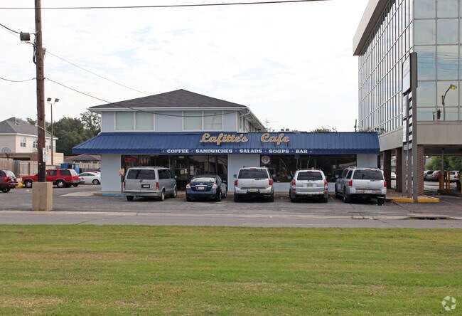
Property Record
6325 Elysian Fields Ave, New Orleans, LA 70122

Property Detail
6325 Elysian Fields Ave
3-8W-4-150-02
SQ 5087 LOT 2 A ELYSIAN FIELDS AVE 102X128
Restaurantbuilding
Orleans
S-RS
Louisiana
C and X Area of minimal flood hazard, usually depicted on FIRMs as above the 500-year flood level.
2 a
2025
0.30 AC
2025
Gentilly/St Claude
002501
New Orleans/Metairie/Kenner
6,600 SF
New Orleans-Metairie, LA
NEARBY LISTINGS FOR SALE OR LEASE
DEMOGRAPHICS near 6325 Elysian Fields Ave
1 mile
3 mile
5 mile
2025 Total Population
11,876
62,081
191,516
2030 Population
11,237
59,108
185,130
Pop Growth 2025-2030
(5.38%)
(4.79%)
(3.33%)
Average Age
39
41
41
2025 Total Households
4,514
24,388
85,010
HH Growth 2025-2030
(6.25%)
(5.30%)
(3.40%)
Median Household Inc
$52,540
$47,533
$51,993
Avg Household Size
2.30
2.40
2.10
2025 Avg HH Vehicles
1.00
1.00
1.00
Median Home Value
$298,482
$279,632
$322,379
Median Year Built
1962
1959
1958
Nearby Places
Map Layers
Map Styles
 Street
 Aerial
Transit
 Traffic
 Biking
Places
Listings with unknown addresses are not visible on the map
- Restaurants
- Banks
- Shops
- Fitness
- Groceries
PUBLIC TRANSPORTATION
COMMUTER RAIL
New Orleans Union Passenger Terminal (City of New Orleans - Amtrak, Crescent - Amtrak, Sunset Limited - Amtrak)
Drive
Walk
Distance
New Orleans Union Passenger Terminal (City of New Orleans - Amtrak, Crescent - Amtrak, Sunset Limited - Amtrak)
13 min
6.4 mi
AIRPORT
Louis Armstrong New Orleans International
Drive
Walk
Distance
Louis Armstrong New Orleans International
25 min
16.2 mi
Freight Ports
Port of New Orleans
Drive
Walk
Distance
Port of New Orleans
19 min
8.8 mi
SALE & LEASE HISTORY
LISTING DATE
SALE/LEASE

May 18, 2017
For Lease
Jul 17, 2018
For Lease
Nearby Properties
Address
Land Use
TOTAL SIZE
Lot Size
Zoning
Address
Land Use
TOTAL SIZE
Lot Size
Zoning
Address
Land Use
TOTAL SIZE
Lot Size
Zoning
150.60 AC
EC
Address
Land Use
TOTAL SIZE
Lot Size
Zoning
33.64 AC
EC
Address
Land Use
TOTAL SIZE
Lot Size
Zoning
225,284 SF
16.83 AC
S-RD
Address
Land Use
TOTAL SIZE
Lot Size
Zoning
7.56 AC
S-LRS1
Address
Land Use
TOTAL SIZE
Lot Size
Zoning
189,613 SF
71.45 AC
S-RD
Address
Land Use
TOTAL SIZE
Lot Size
Zoning
8,300 SF
30.83 AC
EC
Address
Land Use
TOTAL SIZE
Lot Size
Zoning
14.83 AC
EC
Address
Land Use
TOTAL SIZE
Lot Size
Zoning
484,670 SF
18.69 AC
EC
Address
Land Use
TOTAL SIZE
Lot Size
Zoning
173,008 SF
4.03 AC
S-RS
Address
Land Use
TOTAL SIZE
Lot Size
Zoning
16.48 AC
OS-R
Address
Land Use
TOTAL SIZE
Lot Size
Zoning
20.49 AC
S-RS
Address
Land Use
TOTAL SIZE
Lot Size
Zoning
183.59 AC
OS-R
Address
Land Use
TOTAL SIZE
Lot Size
Zoning
136,984 SF
4.67 AC
S-RS
Address
Land Use
TOTAL SIZE
Lot Size
Zoning
98,642 SF
8.32 AC
HU-RS
Address
Land Use
TOTAL SIZE
Lot Size
Zoning
1.14 AC
S-B2
Address
Land Use
TOTAL SIZE
Lot Size
Zoning
104,900 SF
7.37 AC
S-RS
Address
Land Use
TOTAL SIZE
Lot Size
Zoning
108,104 SF
8.98 AC
S-LRS1
Address
Land Use
TOTAL SIZE
Lot Size
Zoning
435,732 SF
29.06 AC
LI
Address
Land Use
TOTAL SIZE
Lot Size
Zoning
31,894 SF
500 AC
MI
Address
Land Use
TOTAL SIZE
Lot Size
Zoning
210,959 SF
6.61 AC
EC
Address
Land Use
TOTAL SIZE
Lot Size
Zoning
7.32 AC
S-RS
Address
Land Use
TOTAL SIZE
Lot Size
Zoning
13.23 AC
MI
Address
Land Use
TOTAL SIZE
Lot Size
Zoning
3.06 AC
HU-RD1
Address
Land Use
TOTAL SIZE
Lot Size
Zoning
95,728 SF
5.01 AC
S-RS
Address
Land Use
TOTAL SIZE
Lot Size
Zoning
94,050 SF
4.96 AC
S-RS
Address
Land Use
TOTAL SIZE
Lot Size
Zoning
98,500 SF
5.54 AC
S-RS
Address
Land Use
TOTAL SIZE
Lot Size
Zoning
6.62 AC
MU-1
Address
Land Use
TOTAL SIZE
Lot Size
Zoning
24.20 AC
EC
Address
Land Use
TOTAL SIZE
Lot Size
Zoning
4.39 AC
S-RS
The World's #1 Commercial Real Estate Marketplace
Connect with us
© 2026 CoStar Group
The information above has been obtained from sources believed reliable. While we do not doubt its accuracy we have not verified it and make no guarantee, warranty or representation about it. It is your responsibility to independently confirm its accuracy and completeness. Any projections, opinions, assumptions, or estimates used are for example only and do not represent the current or future performance of the property. The value of this transaction to you depends on tax and other factors which should be evaluated by your tax, financial, and legal advisors. You and your advisors should conduct a careful, independent investigation of the property to determine to your satisfaction the suitability of the property for your needs.