This feature is unavailable at the moment.
We apologize, but the feature you are trying to access is currently unavailable. We are aware of this issue and our team is working hard to resolve the matter.
Please check back in a few minutes. We apologize for the inconvenience.
- LoopNet Team
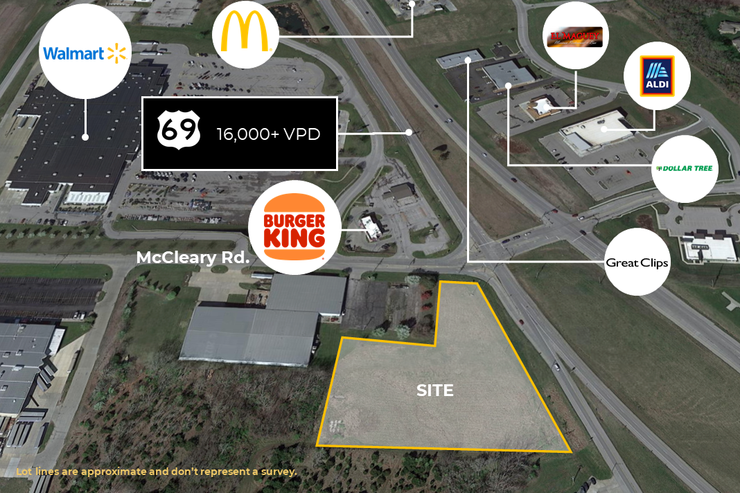
US-69 & McCleary
Excelsior Springs, MO 64024
Prime Highway Intersection Land · Land For Sale
·
3.30 AC

INVESTMENT HIGHLIGHTS
- Prime Highway Intersection
- Highly Visible, High Traffic
- Utilities Available
- 3.3 Acre ± Commercial Site
- $550,000 LOI in hand
- C-3 Zoning
PROPERTY FACTS
| Property Type | Land | Proposed Use | Commercial |
| Property Subtype | Commercial | Total Lot Size | 3.30 AC |
| Zoning | C-3 | ||
| Property Type | Land |
| Property Subtype | Commercial |
| Proposed Use | Commercial |
| Total Lot Size | 3.30 AC |
| Zoning | C-3 |
DESCRIPTION
The subject tract is located along the south side of US Highway 69 entering the west end of the City of Excelsior Springs, Missouri. The subject is located in the southeast quadrant of the intersection of McCleary Road with US Highway 69. The northerly adjoining highway is of divided two-way, four-lane design fronting the subject tract. The McCleary intersection spans the divided highway continuing to the north and south. Electronic signals control both intersections. Rail lines of the I&M Rail roughly parallels to the south of US Highway 69. US Highway 69 runs from Interstate 35 northeast to Excelsior Springs (roundly 9 miles). The split of I-35 and US Highway 69 is in the northern portion of Liberty. Interstate 35 continues north through Kearney to Iowa. US Highway 69 veers north from Excelsior Springs and reconnects with 35 near Missouri Highway 121. Downtown Kansas City, Missouri is located roundly 27 miles southwest of the subject property. Drive time is about 35 minutes. The municipalities of Excelsior Springs, Kearney, and Liberty anchor the northeast portion of the metropolitan area. Kearney is the furthest north while Excelsior Springs is the furthest east. Liberty is the closest of the three cities to the downtown of Kansas City, Missouri. Although Excelsior Springs is located on the northeast quadrant of the greater Kansas City metropolitan area, linkage is quite good and most of the highway systems mentioned above have been improved in recent years. US 69 provides convenient linkage to Interstate 35 and the metropolitan area highway system. US 69 skirts the west side of Excelsior Springs turning to the north while W Jesse James Road/Kearney Road/Missouri Highway 10 provides east/west access through the city. Missouri Highway 92 terminates at US Highway 69 in the northwest corner of Excelsior Springs and runs west to Interstate 29 near Platte City, Missouri just north of KCI Airport. Missouri Highway 92 provides linkage to Interstate 35, US 169 Highway, and finally Interstate 29. Area/Configuration Per the legal description contained in the last deed filed on the subject tract, the subject site contains 3.287 acres or 143,182 square feet. The Clay County GIS Mapping indicates 3.3 acres. The configuration of the subject site is essentially L-shaped. Frontage Along the north perimeter of the subject tract frontage of 522.88 feet exists along the south lanes of eastbound US Highway 69 and W Jesse James Road which splits with the federal highway and continues east into the downtown of Excelsior Springs (US Highway 69 then veers to the northeast). US Highway 69 is two-lane design while W Jesse James Road is of one-lane design. The subject tract also has 67.39 feet of frontage along its west perimeter on the east side of McCleary Road which is two lanes with a center turn lane and a dedicated right turn lane unto US 69/Jesse James Road. Topography The topography of the subject tract is level and at street grade in the northern and western portions. However, the tract falls off to the southeast. According to USGS topographic mapping (Kearney US published December 31, 2014; see Topography Map on the second page following), the plateau areas are roundly 900 feet in elevation falling off 10 to 15 feet to the southeast. Roundly 20% of the tract is covered in trees. Flood Plain According to FIRM Community Panel No. 29047C0159E (dated August 3, 2015), the subject parcel lies outside of the designated 100-year flood plain area (Zone X; areas determined to be outside the 0.2% annual chance floodplain). (See Flood Plain Map on the second page following.) Utilities The city of Excelsior Springs provides water and sewer service to the subject property. Electric service is from AmerenUE. The Missouri Gas Energy (MGE; a division of Southern Union Company, publicly traded and state regulated) provides natural gas service. Zoning The subject is zoned C-3, Service Business District, which is the primary commercial zoning district for retail and other services located outside of the downtown. School District The subject parcel resides within the boundaries served by the Excelsior Springs School District. The district operates 3 elementary schools, 1 middle school, and 2 high schools (Excelsior Springs HS and Excelsior Springs Tech. HS) serving 2,869 students. *Above information according to Belke Appraisal report. HIGHLIGHTS • Prime Highway Intersection Land • SEC US-69 Highway & McCleary Road • 3.3 Acre ± Commercial Site • Traffic Lighted Intersection • Excellent Frontage & Visibility • High Traffic Location • Across from Walmart & Burger King • Utilities Available • C-3 Zoning – Ready for Your Business! • Parcel ID: 12204000201105 • 2020 Real Estate Taxes: $6144
PROPERTY TAXES
| Parcel Number | 12-204-00-02-011.05 | Improvements Assessment | $0 |
| Land Assessment | $0 | Total Assessment | $864,190 |
PROPERTY TAXES
