Property Record
589 Springridge Rd, Clinton, MS 39056
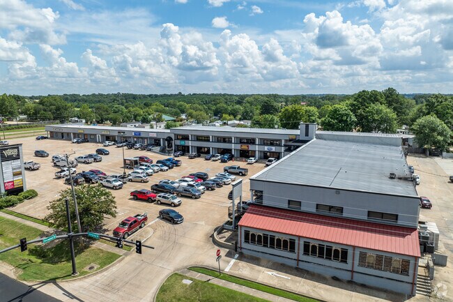

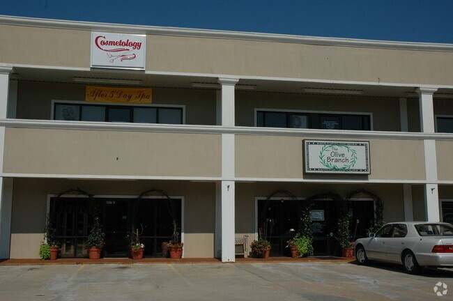
Property Detail
589 Springridge Rd
2860-0834-750
538.36 FT E/S SPRINGRIDGE RD X 342 FT BK SW COR THAT PT SE 1/4 NW 1/4 E OF RD SEC 32 T6 R1W CITY OF CLINTON LESS TO CITY FOR ST
Medicalbuilding
HINDS
B and X Area of moderate flood hazard, usually the area between the limits of the 100-year and 500-year floods.
Mississippi
2024
3 AC
2025
South Jackson
010400
Jackson
61,784 SF
Jackson, MS
NEARBY LISTINGS FOR SALE OR LEASE
DEMOGRAPHICS near 589 Springridge Rd
1 mile
3 mile
5 mile
2025 Total Population
4,584
23,339
44,878
2030 Population
4,254
22,053
42,341
Pop Growth 2025-2030
(7.20%)
(5.51%)
(5.65%)
Average Age
38
38
39
2025 Total Households
1,864
8,922
17,601
HH Growth 2025-2030
(7.51%)
(5.77%)
(5.95%)
Median Household Inc
$70,424
$64,829
$57,892
Avg Household Size
2.40
2.40
2.40
2025 Avg HH Vehicles
2.00
2.00
2.00
Median Home Value
$234,590
$219,061
$192,612
Median Year Built
1979
1980
1978
Nearby Places
Map Layers
Map Styles
 Street
 Aerial
Transit
 Traffic
 Biking
Places
Listings with unknown addresses are not visible on the map
- Restaurants
- Banks
- Shops
- Fitness
- Groceries
PUBLIC TRANSPORTATION
AIRPORT
Jackson-Medgar Wiley Evers International
Drive
Walk
Distance
Jackson-Medgar Wiley Evers International
28 min
19.4 mi
Freight Ports
Port of Greater Baton Rouge
Drive
Walk
Distance
Port of Greater Baton Rouge
203 min
181.8 mi
SALE & LEASE HISTORY
LISTING DATE
SALE/LEASE

Sep 25, 2016
For Lease
Nearby Properties
Address
Land Use
TOTAL SIZE
Lot Size
Zoning
Address
Land Use
TOTAL SIZE
Lot Size
Zoning
40,255 SF
Address
Land Use
TOTAL SIZE
Lot Size
Zoning
91,933 SF
1 AC
Address
Land Use
TOTAL SIZE
Lot Size
Zoning
30,524 SF
10.90 AC
Address
Land Use
TOTAL SIZE
Lot Size
Zoning
314,964 SF
26.02 AC
Address
Land Use
TOTAL SIZE
Lot Size
Zoning
41,616 SF
176,418.04 AC
Address
Land Use
TOTAL SIZE
Lot Size
Zoning
37,293 SF
10 AC
Address
Land Use
TOTAL SIZE
Lot Size
Zoning
32,617 SF
348,480.26 AC
Address
Land Use
TOTAL SIZE
Lot Size
Zoning
40.55 AC
Address
Land Use
TOTAL SIZE
Lot Size
Zoning
188,317 SF
23 AC
Address
Land Use
TOTAL SIZE
Lot Size
Zoning
90,036 SF
79.05 AC
Address
Land Use
TOTAL SIZE
Lot Size
Zoning
102,117 SF
0.01 AC
Address
Land Use
TOTAL SIZE
Lot Size
Zoning
57,673 SF
16.83 AC
Address
Land Use
TOTAL SIZE
Lot Size
Zoning
66,132 SF
8.91 AC
Address
Land Use
TOTAL SIZE
Lot Size
Zoning
148,263 SF
11.26 AC
Address
Land Use
TOTAL SIZE
Lot Size
Zoning
107,193 SF
10 AC
Address
Land Use
TOTAL SIZE
Lot Size
Zoning
33,944 SF
2.10 AC
Address
Land Use
TOTAL SIZE
Lot Size
Zoning
40,859 SF
3.51 AC
Address
Land Use
TOTAL SIZE
Lot Size
Zoning
20,902 SF
2 AC
Address
Land Use
TOTAL SIZE
Lot Size
Zoning
15.26 AC
Address
Land Use
TOTAL SIZE
Lot Size
Zoning
126,024 SF
8.20 AC
Address
Land Use
TOTAL SIZE
Lot Size
Zoning
96,372 SF
9.19 AC
Address
Land Use
TOTAL SIZE
Lot Size
Zoning
22,053 SF
43 AC
Address
Land Use
TOTAL SIZE
Lot Size
Zoning
98,531 SF
348,480.26 AC
Address
Land Use
TOTAL SIZE
Lot Size
Zoning
163,800 SF
9.10 AC
Address
Land Use
TOTAL SIZE
Lot Size
Zoning
56,960 SF
0.76 AC
Address
Land Use
TOTAL SIZE
Lot Size
Zoning
138,902 SF
8 AC
Address
Land Use
TOTAL SIZE
Lot Size
Zoning
88,733 SF
9.74 AC
Address
Land Use
TOTAL SIZE
Lot Size
Zoning
93,912 SF
7.75 AC
Address
Land Use
TOTAL SIZE
Lot Size
Zoning
45,532 SF
5 AC
Address
Land Use
TOTAL SIZE
Lot Size
Zoning
111,536 SF
10 AC
The World's #1 Commercial Real Estate Marketplace
Connect with us
© 2026 CoStar Group
The information above has been obtained from sources believed reliable. While we do not doubt its accuracy we have not verified it and make no guarantee, warranty or representation about it. It is your responsibility to independently confirm its accuracy and completeness. Any projections, opinions, assumptions, or estimates used are for example only and do not represent the current or future performance of the property. The value of this transaction to you depends on tax and other factors which should be evaluated by your tax, financial, and legal advisors. You and your advisors should conduct a careful, independent investigation of the property to determine to your satisfaction the suitability of the property for your needs.