Property Record
33 Salem Rd, Montevallo, AL 35115
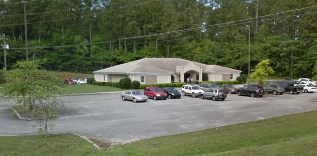

Property Detail
33 Salem Rd
275212001003000
BEG INT S ROW CO RD 15 & W ROW ST HWY 119 NW ON ROW 24.8 SW32.8 NW39.36 NE32.8 NE380.19 SW530(S) SE50 SW125 ELY437.87 N200 E150 N111.43 TO POB LESS: ACQUIRED ROW PROJECT STPB H-9802(98)
Medicalbuilding
Shelby
B and X Area of moderate flood hazard, usually the area between the limits of the 100-year and 500-year floods.
Alabama
2024
4.47 AC
2024
I-65 Corr/S Shelby County
030407
Birmingham
5,891 SF
Birmingham, AL
NEARBY LISTINGS FOR SALE OR LEASE
-
-
View all Montevallo listings for lease on LoopNet.com
DEMOGRAPHICS near 33 Salem Rd
1 mile
3 mile
5 mile
2025 Total Population
3,841
9,189
16,391
2030 Population
4,004
9,696
17,297
Pop Growth 2025-2030
+ 4.24%
+ 5.52%
+ 5.53%
Average Age
34
38
39
2025 Total Households
1,204
3,367
6,069
HH Growth 2025-2030
+ 5.40%
+ 6.15%
+ 5.88%
Median Household Inc
$42,874
$47,997
$57,343
Avg Household Size
2.20
2.40
2.50
2025 Avg HH Vehicles
2.00
2.00
2.00
Median Home Value
$241,666
$206,606
$224,195
Median Year Built
1989
1989
1992
Nearby Places
Map Layers
Map Styles
 Street
 Aerial
Transit
 Traffic
 Biking
Places
Listings with unknown addresses are not visible on the map
- Restaurants
- Banks
- Shops
- Fitness
- Groceries
PUBLIC TRANSPORTATION
AIRPORT
Birmingham-Shuttlesworth International
Drive
Walk
Distance
Birmingham-Shuttlesworth International
55 min
38.3 mi
SALE & LEASE HISTORY
LISTING DATE
SALE/LEASE

May 03, 2017
For Lease
Nearby Properties
Address
Land Use
TOTAL SIZE
Lot Size
Zoning
Address
Land Use
TOTAL SIZE
Lot Size
Zoning
10,352 SF
75 AC
Address
Land Use
TOTAL SIZE
Lot Size
Zoning
2,708 SF
297.42 AC
Address
Land Use
TOTAL SIZE
Lot Size
Zoning
16,530 SF
3.76 AC
Address
Land Use
TOTAL SIZE
Lot Size
Zoning
15,620 SF
5.61 AC
Address
Land Use
TOTAL SIZE
Lot Size
Zoning
78,043 SF
4.59 AC
Address
Land Use
TOTAL SIZE
Lot Size
Zoning
41,325 SF
3.74 AC
Address
Land Use
TOTAL SIZE
Lot Size
Zoning
6,660 SF
7.70 AC
Address
Land Use
TOTAL SIZE
Lot Size
Zoning
2,475 SF
14.20 AC
Address
Land Use
TOTAL SIZE
Lot Size
Zoning
57,281 SF
15 AC
Address
Land Use
TOTAL SIZE
Lot Size
Zoning
159,010 SF
8.60 AC
Address
Land Use
TOTAL SIZE
Lot Size
Zoning
2,569 SF
8 AC
Address
Land Use
TOTAL SIZE
Lot Size
Zoning
7,481 SF
6.20 AC
Address
Land Use
TOTAL SIZE
Lot Size
Zoning
4,128 SF
4.20 AC
Address
Land Use
TOTAL SIZE
Lot Size
Zoning
47,934 SF
3.45 AC
Address
Land Use
TOTAL SIZE
Lot Size
Zoning
72,232 SF
44 AC
Address
Land Use
TOTAL SIZE
Lot Size
Zoning
14,628 SF
2.73 AC
Address
Land Use
TOTAL SIZE
Lot Size
Zoning
19,000 SF
3.10 AC
Address
Land Use
TOTAL SIZE
Lot Size
Zoning
5,800 SF
0.99 AC
Address
Land Use
TOTAL SIZE
Lot Size
Zoning
16,410 SF
1.03 AC
Address
Land Use
TOTAL SIZE
Lot Size
Zoning
17,689 SF
0.98 AC
Address
Land Use
TOTAL SIZE
Lot Size
Zoning
7,760 SF
7.30 AC
Address
Land Use
TOTAL SIZE
Lot Size
Zoning
6,652 SF
2.81 AC
Address
Land Use
TOTAL SIZE
Lot Size
Zoning
60,000 SF
13 AC
Address
Land Use
TOTAL SIZE
Lot Size
Zoning
4,824 SF
0.68 AC
Address
Land Use
TOTAL SIZE
Lot Size
Zoning
8,763 SF
2.50 AC
Address
Land Use
TOTAL SIZE
Lot Size
Zoning
10,200 SF
0.97 AC
Address
Land Use
TOTAL SIZE
Lot Size
Zoning
2,100 SF
3.40 AC
Address
Land Use
TOTAL SIZE
Lot Size
Zoning
13,600 SF
1 AC
The World's #1 Commercial Real Estate Marketplace
Connect with us
© 2026 CoStar Group
The information above has been obtained from sources believed reliable. While we do not doubt its accuracy we have not verified it and make no guarantee, warranty or representation about it. It is your responsibility to independently confirm its accuracy and completeness. Any projections, opinions, assumptions, or estimates used are for example only and do not represent the current or future performance of the property. The value of this transaction to you depends on tax and other factors which should be evaluated by your tax, financial, and legal advisors. You and your advisors should conduct a careful, independent investigation of the property to determine to your satisfaction the suitability of the property for your needs.