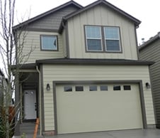
Property Record
7420 Ne 58Th Way, Vancouver, WA 98662
NEARBY LISTINGS FOR SALE OR LEASE
Property Detail
7420 Ne 58Th Way
Portland-Vancouver-Hillsboro, OR-WA
Fourth Plain Homestead Lot;Walnut Villag
104990-020
Clark
Sfr
Washington
X
0.05 AC
53011C0386D
Walnut Grove
1,647 SF
Portland
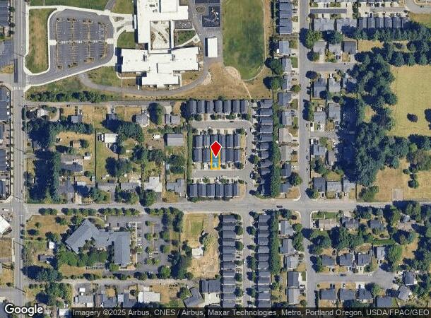
DEMOGRAPHICS near 7420 Ne 58Th Way
1 Mile
3 Mile
5 Mile
2024 Total Population
19,954
131,078
296,499
2029 Population
21,555
141,310
320,259
Pop Growth 2024-2029
+ 8.02%
+ 7.81%
+ 8.01%
Average Age
40
38
39
2024 Total Households
8,385
49,780
114,833
HH Growth 2024-2029
+ 8.05%
+ 7.92%
+ 8.23%
Median Household Inc
$66,503
$70,675
$75,557
Avg Household Size
2.30
2.50
2.50
2024 Avg HH Vehicles
2.00
2.00
2.00
Median Home Value
$367,158
$373,533
$403,685
Median Year Built
1995
1989
1989
Nearby Places
Map Layers
Map Styles
 Street
 Aerial
- Restaurants
- Banks
- Shops
- Fitness
- Groceries
PUBLIC TRANSPORTATION
COMMUTER RAIL
Vancouver (Amtrak Cascades - Amtrak, Coast Starlight - Amtrak, Empire Builder - Amtrak)
DRIVE
WALK
Distance
Vancouver (Amtrak Cascades - Amtrak, Coast Starlight - Amtrak, Empire Builder - Amtrak)
13 min
6.9 mi
AIRPORT
Portland International
DRIVE
WALK
Distance
Portland International
19 min
10.5 mi
Freight Ports
Port of Vancouver
DRIVE
WALK
Distance
Port of Vancouver
15 min
7.2 mi
SALE & LEASE HISTORY
LISTING DATE
SALE/LEASE

Jun 06, 2017
For Sale
Nearby Properties
Address
Land Use
TOTAL SIZE
Lot Size
Zoning
Address
Land Use
TOTAL SIZE
Lot Size
Zoning
2,279,068 SF
137.78 AC
IL
Address
Land Use
TOTAL SIZE
Lot Size
Zoning
780,691 SF
17.66 AC
OCI
Address
Land Use
TOTAL SIZE
Lot Size
Zoning
304,876 SF
11.34 AC
R-18
Address
Land Use
TOTAL SIZE
Lot Size
Zoning
340,500 SF
19.01 AC
R-22
Address
Land Use
TOTAL SIZE
Lot Size
Zoning
281,852 SF
13.14 AC
OR-22
Address
Land Use
TOTAL SIZE
Lot Size
Zoning
284,788 SF
13.72 AC
R-30
Address
Land Use
TOTAL SIZE
Lot Size
Zoning
699,292 SF
30.16 AC
CG
Address
Land Use
TOTAL SIZE
Lot Size
Zoning
229,962 SF
30.18 AC
R-6
Address
Land Use
TOTAL SIZE
Lot Size
Zoning
49,124 SF
17.26 AC
R-18
Address
Land Use
TOTAL SIZE
Lot Size
Zoning
282,460 SF
7.85 AC
R-18
Address
Land Use
TOTAL SIZE
Lot Size
Zoning
520,384 SF
9.51 AC
R-30
Address
Land Use
TOTAL SIZE
Lot Size
Zoning
280,065 SF
14.80 AC
R-22
Address
Land Use
TOTAL SIZE
Lot Size
Zoning
201,471 SF
8.76 AC
CG
Address
Land Use
TOTAL SIZE
Lot Size
Zoning
244,812 SF
16.33 AC
CC
Address
Land Use
TOTAL SIZE
Lot Size
Zoning
280,541 SF
63.94 AC
IL
Address
Land Use
TOTAL SIZE
Lot Size
Zoning
203,193 SF
4.90 AC
R-30
Address
Land Use
TOTAL SIZE
Lot Size
Zoning
177,297 SF
11.10 AC
R-18
Address
Land Use
TOTAL SIZE
Lot Size
Zoning
194,195 SF
8.65 AC
R-18
Address
Land Use
TOTAL SIZE
Lot Size
Zoning
144,267 SF
5.83 AC
R-22
Address
Land Use
TOTAL SIZE
Lot Size
Zoning
134,442 SF
6.35 AC
OCI
Address
Land Use
TOTAL SIZE
Lot Size
Zoning
369,864 SF
74.42 AC
R-9
Address
Land Use
TOTAL SIZE
Lot Size
Zoning
169,980 SF
15.98 AC
R-18
Address
Land Use
TOTAL SIZE
Lot Size
Zoning
220,905 SF
9.04 AC
R-22
Address
Land Use
TOTAL SIZE
Lot Size
Zoning
151,590 SF
7.38 AC
R-22
Address
Land Use
TOTAL SIZE
Lot Size
Zoning
421,150 SF
9.50 AC
R-30
Address
Land Use
TOTAL SIZE
Lot Size
Zoning
325,040 SF
3.05 AC
R-22
Address
Land Use
TOTAL SIZE
Lot Size
Zoning
510,468 SF
24.42 AC
IL
Address
Land Use
TOTAL SIZE
Lot Size
Zoning
137,393 SF
6.89 AC
R-30
Address
Land Use
TOTAL SIZE
Lot Size
Zoning
140,325 SF
2.93 AC
R-18
Address
Land Use
TOTAL SIZE
Lot Size
Zoning
153,114 SF
4.53 AC
R-22
The World's #1 Commercial Real Estate Marketplace
Connect with us
© 2025 CoStar Group
The information above has been obtained from sources believed reliable. While we do not doubt its accuracy we have not verified it and make no guarantee, warranty or representation about it. It is your responsibility to independently confirm its accuracy and completeness. Any projections, opinions, assumptions, or estimates used are for example only and do not represent the current or future performance of the property. The value of this transaction to you depends on tax and other factors which should be evaluated by your tax, financial, and legal advisors. You and your advisors should conduct a careful, independent investigation of the property to determine to your satisfaction the suitability of the property for your needs.