Log In/Sign Up
Your email has been sent.
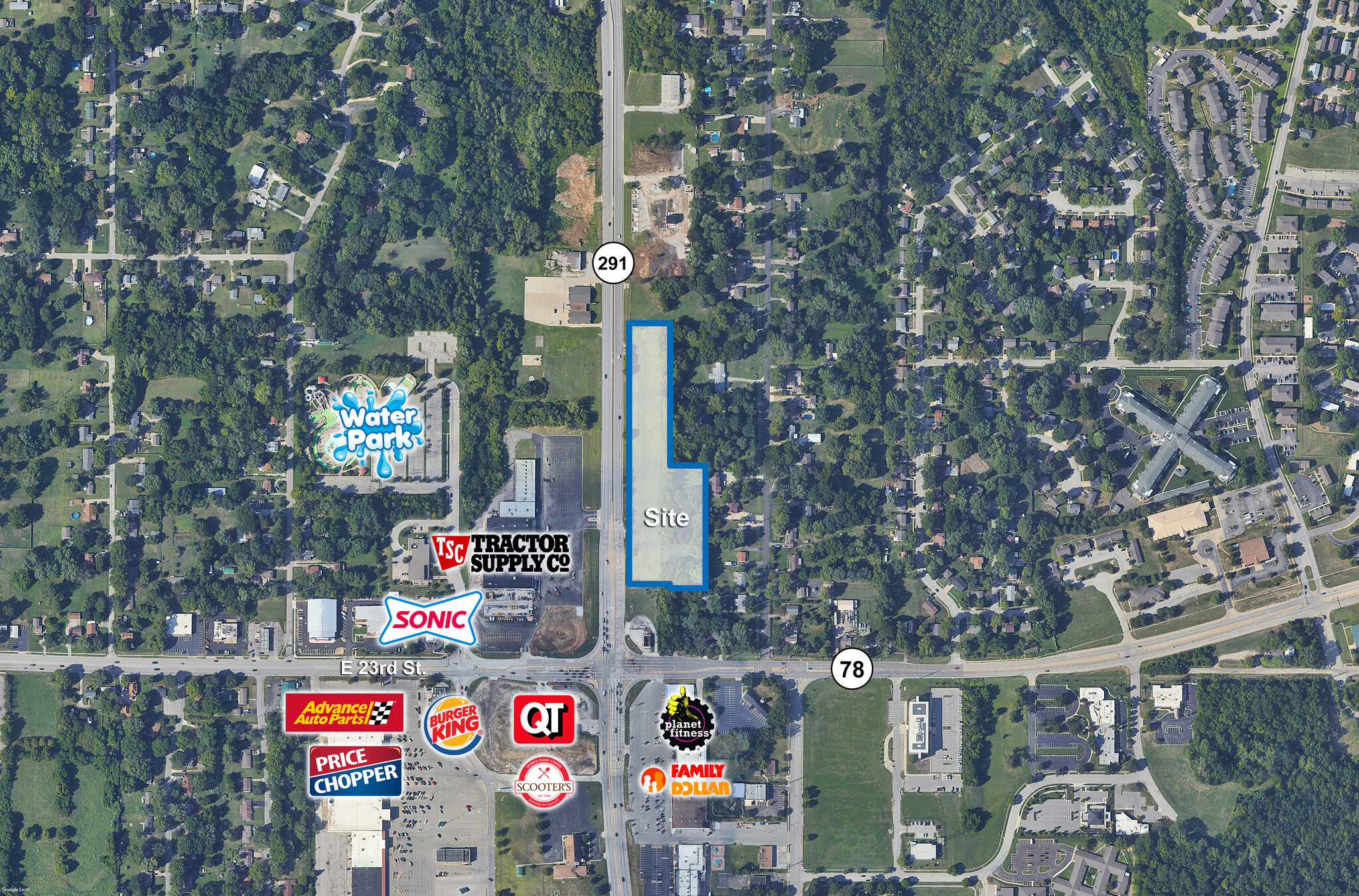
2117 Route 219 Hwy 5.18 Acres of Commercial Land Offered at $675,000 in Independence, MO 64057

Executive Summary
5.18 +/- acre development site.
Zoned Neighborhood Commercial District (C-1).
Located just north of high traffic count intersection.
Two potential curb cuts along frontage.
Utilities available.
Offered at $3.00 per square foot
Zoned Neighborhood Commercial District (C-1).
Located just north of high traffic count intersection.
Two potential curb cuts along frontage.
Utilities available.
Offered at $3.00 per square foot
Property Facts
| Price | $675,000 | Property Subtype | Commercial |
| Sale Type | Investment | Proposed Use | Commercial |
| No. Lots | 1 | Total Lot Size | 5.18 AC |
| Property Type | Land | ||
| Zoning | C-2 - General Commercial | ||
| Price | $675,000 |
| Sale Type | Investment |
| No. Lots | 1 |
| Property Type | Land |
| Property Subtype | Commercial |
| Proposed Use | Commercial |
| Total Lot Size | 5.18 AC |
| Zoning | C-2 - General Commercial |
1 Lot Available
Lot
| Price | $675,000 | Lot Size | 5.18 AC |
| Price Per AC | $130,308.88 |
| Price | $675,000 |
| Price Per AC | $130,308.88 |
| Lot Size | 5.18 AC |
5.18 +/- acre development site. Zoned Neighborhood Commercial District (C-1). Located just north of high traffic count intersection. Two potential curb cuts along frontage. Utilities available. Offered at $3.00 per square foot
1 1
Fairly walkable
40/100
Exceptionally drivable
100/100
Limited public transit
30/100
Not bikeable
10/100
Property Taxes
| Parcel Number | 25-420-02-44-00-0-00-000 | Improvements Assessment | $0 |
| Land Assessment | $160,461 | Total Assessment | $160,461 |
Property Taxes
Parcel Number
25-420-02-44-00-0-00-000
Land Assessment
$160,461
Improvements Assessment
$0
Total Assessment
$160,461
Contacts
-
 Michael VanBuskirk SIOR, CCIM,CRE
 -
 Christopher Robertson, CCIM
 -
 Raegen Kersey
 -
 Newmark Zimmer
1 of 2
Videos
Matterport 3D Exterior
Matterport 3D Tour
Photos
Street View
Street
Map
1 of 1
Presented by
2117 Route 219 Hwy
Already a member? Log In
Hmm, there seems to have been an error sending your message. Please try again.
Thanks! Your message was sent.