Property Record
21 Roadway Dr, Carlisle, PA 17015
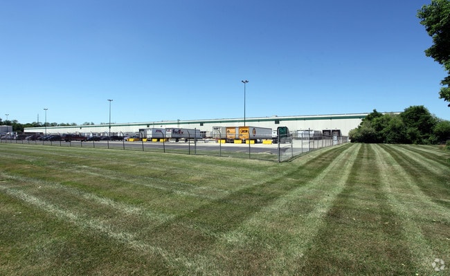
Property Detail
21 Roadway Dr
Harrisburg-Carlisle, PA
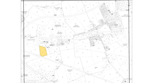
ROADWAY DRIVE #L-0005 + LOT 5 & 6-A PB 55 PG 21
21-07-0465-024
Cumberland
Commercialbuilding
Pennsylvania
B and X Area of moderate flood hazard, usually the area between the limits of the 100-year and 500-year floods.
5,6-a
2026
35.80 AC
2026
Harrisburg Area West
012400
Philadelphia
NEARBY LISTINGS FOR SALE OR LEASE
DEMOGRAPHICS near 21 Roadway Dr
1 mile
3 mile
5 mile
2025 Total Population
829
9,716
59,168
2030 Population
884
10,307
62,369
Pop Growth 2025-2030
+ 6.63%
+ 6.08%
+ 5.41%
Average Age
48
44
41
2025 Total Households
353
3,806
23,653
HH Growth 2025-2030
+ 7.08%
+ 6.31%
+ 5.53%
Median Household Inc
$72,567
$74,077
$75,705
Avg Household Size
2.20
2.40
2.40
2025 Avg HH Vehicles
2.00
2.00
2.00
Median Home Value
$357,499
$302,455
$281,785
Median Year Built
1994
1991
1980
Nearby Places
Map Layers
Map Styles
 Street
 Aerial
Layers
 Traffic
 Biking
Places
Listings with unknown addresses are not visible on the map
- Restaurants
- Banks
- Shops
- Fitness
- Groceries
PUBLIC TRANSPORTATION
AIRPORT
Harrisburg International
Drive
Walk
Distance
Harrisburg International
41 min
24.2 mi
Freight Ports
Port of Baltimore
Drive
Walk
Distance
Port of Baltimore
127 min
88.0 mi
Nearby Properties
Address
Land Use
TOTAL SIZE
Lot Size
Zoning
Address
Land Use
TOTAL SIZE
Lot Size
Zoning
123.14 AC
Address
Land Use
TOTAL SIZE
Lot Size
Zoning
78.40 AC
Address
Land Use
TOTAL SIZE
Lot Size
Zoning
61.58 AC
Address
Land Use
TOTAL SIZE
Lot Size
Zoning
56.28 AC
Address
Land Use
TOTAL SIZE
Lot Size
Zoning
33.84 AC
Address
Land Use
TOTAL SIZE
Lot Size
Zoning
67.20 AC
Address
Land Use
TOTAL SIZE
Lot Size
Zoning
45.21 AC
Address
Land Use
TOTAL SIZE
Lot Size
Zoning
1,802 SF
101.23 AC
Address
Land Use
TOTAL SIZE
Lot Size
Zoning
55.72 AC
Address
Land Use
TOTAL SIZE
Lot Size
Zoning
38.73 AC
Address
Land Use
TOTAL SIZE
Lot Size
Zoning
120.28 AC
Address
Land Use
TOTAL SIZE
Lot Size
Zoning
36.15 AC
Address
Land Use
TOTAL SIZE
Lot Size
Zoning
48.31 AC
Address
Land Use
TOTAL SIZE
Lot Size
Zoning
18.01 AC
Address
Land Use
TOTAL SIZE
Lot Size
Zoning
113.58 AC
Address
Land Use
TOTAL SIZE
Lot Size
Zoning
Address
Land Use
TOTAL SIZE
Lot Size
Zoning
13.75 AC
Address
Land Use
TOTAL SIZE
Lot Size
Zoning
Address
Land Use
TOTAL SIZE
Lot Size
Zoning
42.75 AC
Address
Land Use
TOTAL SIZE
Lot Size
Zoning
43.90 AC
Address
Land Use
TOTAL SIZE
Lot Size
Zoning
9.33 AC
Address
Land Use
TOTAL SIZE
Lot Size
Zoning
21.56 AC
Address
Land Use
TOTAL SIZE
Lot Size
Zoning
10.64 AC
Address
Land Use
TOTAL SIZE
Lot Size
Zoning
24.39 AC
Address
Land Use
TOTAL SIZE
Lot Size
Zoning
58.56 AC
Address
Land Use
TOTAL SIZE
Lot Size
Zoning
Address
Land Use
TOTAL SIZE
Lot Size
Zoning
7.67 AC
Address
Land Use
TOTAL SIZE
Lot Size
Zoning
Address
Land Use
TOTAL SIZE
Lot Size
Zoning
26.53 AC
The World's #1 Commercial Real Estate Marketplace
Connect with us
© 2026 CoStar Group
The information above has been obtained from sources believed reliable. While we do not doubt its accuracy we have not verified it and make no guarantee, warranty or representation about it. It is your responsibility to independently confirm its accuracy and completeness. Any projections, opinions, assumptions, or estimates used are for example only and do not represent the current or future performance of the property. The value of this transaction to you depends on tax and other factors which should be evaluated by your tax, financial, and legal advisors. You and your advisors should conduct a careful, independent investigation of the property to determine to your satisfaction the suitability of the property for your needs.