Your email has been sent.
Site at the Junction of Ashford Road And Square Hill 0.12 Acres of Residential Land Offered at $804,420 in Maidstone ME14 5BH
INVESTMENT HIGHLIGHTS
- Within Maidstone Borough Councils designated Urban Area
- No Listed Building or Heritage Assets on site or in the immediate vicinity
- Other residential planning applications in the vicinity show that the principle of residential development is well established and supported by Maidst
- Local Plan Review 2021-2028 (2024) (LPRSP2) designates the Urban Area as a sustainable location and a key focus for new development
- Flood Zone 1 (minimum risk in Environment Agency flood risk map)
- Not within the boundary or setting of of a Conservation Area
EXECUTIVE SUMMARY
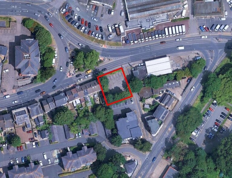
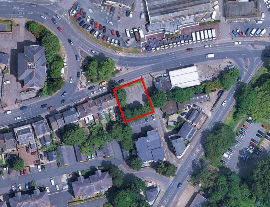
- Area edged red in aerial photograph is indicative only. Land to be sold is that registered with the Land Registry.
- Site almost square and level.
- Surfaced with asphalt and chippings.
- Previously developed with 6 terrace houses but demolished prior to 1968 and used as a car park since then.
Location
The site is situated on the southern side of the Ashford Road (A20) approximately 0.4 mile to the east of Maidstone town centre between a terrace of houses to the west and the Texaco garage to the east. To the north of the A20 is the Haynes main Ford dealership. Vehicular access is from Square Hill, a road running south from the eastern boundary of the site.
Accommodation
Approx. 0.12 acres (500 sq m)
Although there are no services on site, it is anticipated that all mains services will be nearby.
Prospective applicants should, however, make their own enquiries and satisfy themselves as to the availability for their own use.
Rateable Value
Description: Details awaited.
Rateable Value:
UBR in £: 49.9p
Rates Payable:
Please note that interested parties are advised to make their own enquiries of Maidstone Borough Council Rates Department (01622 602230) or by email at businessrates@midkent.gov.uk to ascertain the precise rates payable.
Planning & Building Regulations
- Previously developed with 6 terrace houses but demolished prior to 1968 and used as a car park since then.
- Within Maidstone Borough Councils designated Urban Area.
- Local Plan Review 2021-2028 (2024) (LPRSP2) designates the Urban Area as a sustainable location and a key focus for new development.
- No planning applications recorded for this site.
- Other residential planning applications in the vicinity show that the principle of residential development is well established and supported by Maidstone BC.
- It is the responsibility of the purchaser to satisfy themselves as to the planning situation with regard to the site.
- No Listed Building or Heritage Assets on site or in the immediate vicinity.
- Not within the boundary or setting of of a Conservation Area.
- Flood Zone 1 (minimum risk in Environment Agency flood risk map).
Legal Costs
Each party to be responsible for their own legal and other costs associated with the transaction.
PROPERTY FACTS
| Price | $804,420 | Property Type | Land |
| Sale Type | Investment | Property Subtype | Residential |
| Tenure | Freehold | Proposed Use | Single Family Residence |
| No. Lots | 1 | Total Lot Size | 0.12 AC |
| Price | $804,420 |
| Sale Type | Investment |
| Tenure | Freehold |
| No. Lots | 1 |
| Property Type | Land |
| Property Subtype | Residential |
| Proposed Use | Single Family Residence |
| Total Lot Size | 0.12 AC |
1 LOT AVAILABLE
Lot
| Price | $804,420 | Lot Size | 0.12 AC |
| Price Per AC | $6,703,500.22 |
| Price | $804,420 |
| Price Per AC | $6,703,500.22 |
| Lot Size | 0.12 AC |
The land to be sold is registered with the Land Registry Title Number K434924. For sale freehold with vacant possession. Offers are sought on a private treaty basis both on an unconditional and subject to planning basis.
DESCRIPTION
The site is situated on the southern side of the Ashford Road (A20) approximately 0.4 mile to the east of Maidstone town centre between a terrace of houses to the west and the Texaco garage to the east. To the north of the A20 is the Haynes main Ford dealership. Vehicular access is from Square Hill, a road running south from the eastern boundary of the site. Approx. 0.12 acres (500 sq m) Although there are no services on site, it is anticipated that all mains services will be nearby. Prospective applicants should, however, make their own enquiries and satisfy themselves as to the availability for their own use.

Presented by

Site at the Junction of Ashford Road And Square Hill
Hmm, there seems to have been an error sending your message. Please try again.
Thanks! Your message was sent.