Your email has been sent.

St. Marys Rd - Land At Upton Manor Farm 1.33 Acres of Commercial Land in Brixham TQ5 9QH


Investment Highlights
- Brownfield redevelopment site
- 1.33 acres (0.54 hectares)
- 21.4% affordable housing units on site
- Planning reference - P/2026/0553
- Planning permission for 28 residential dwellings
- Freehold interest
Executive Summary
PLANNING - The planning application, which proposed the detailed application for the demolition of the existing industrial buildings and erection of 28no. residential dwellings (22no. open market and 6no. affordable) together with access, estate roads, landscaping and associated infrastructure was allowed at appeal, with the Planning Inspectorate granting planning permission for the site on 5th December 2025. Planning reference - P/2026/0553 Appeal reference - APP/X1165/W/25/3368343
Property Facts
| Sale Type | Investment | Property Subtype | Commercial |
| Tenure | Freehold | Proposed Use | Apartment Units |
| No. Lots | 1 | Total Lot Size | 1.33 AC |
| Property Type | Land |
| Sale Type | Investment |
| Tenure | Freehold |
| No. Lots | 1 |
| Property Type | Land |
| Property Subtype | Commercial |
| Proposed Use | Apartment Units |
| Total Lot Size | 1.33 AC |
1 Lot Available
Lot
| Lot Size | 1.33 AC |
| Lot Size | 1.33 AC |
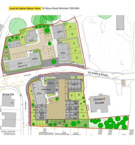
The site is split into two parcels, with the land known as St Mary sitting to the north of St Mary’s Road and the Old Dairy sitting to the south of St Mary’s Road. The extent of the land for sale is approximately 1.33 acres (0.54 hectares).
Description
The site is split into two parcels, with the land known as St Mary sitting to the north of St Mary’s Road and the Old Dairy sitting to the south of St Mary’s Road. The extent of the land for sale is identified on the site plan and the gross site area is approximately 1.33 acres (0.54 hectares). The site comprises a mixture of one, two and three storey old stone and rendered offices and workshops in a poor state of disrepair, as well as hard standing and car parking. The St Marys parcel is relatively flat, however the Old Dairy site slopes gradually from south east to north west. The site is accessed via St Mary’s Road, which provides access from Higher Brixham via Upton Manor Road and connects through to Sharkham Point to the east. The nearest railway stations are Paignton 6 miles to the north, and Totnes 10 miles to the west, providing direct trains to Newton Abbot and Exeter to the North and Penzance to the South. Brixham is a historic fishing town located in Torbay in South Devon. It is approximately 30 miles south of Exeter and 33 miles east of Plymouth. The town has good communication links and is located off the A3022, which provides direct access onto the A385 and A380 leading to Totnes and Ivybridge to the west and Newton Abbot to the north. Brixham provides a range of community facilities including pre-schools and primary schools, church’s and public houses.


Presented by
St. Marys Rd - Land At Upton Manor Farm
Hmm, there seems to have been an error sending your message. Please try again.
Thanks! Your message was sent.