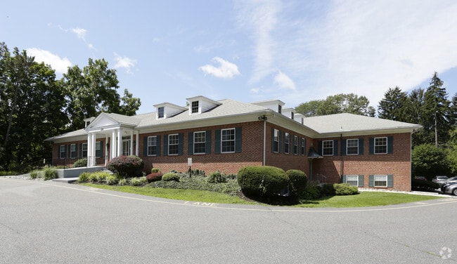
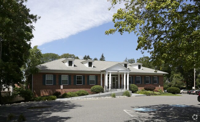
Property Record
0 3Rd St, Media, PA 19063


Current Lease Availabilities
Property Detail
0 3Rd St
26-00-01802-00
2 STY OFC PROF BLDG 46 X 90 PART OF F 1326
Officebuilding
DELAWARE
B and X Area of moderate flood hazard, usually the area between the limits of the 100-year and 500-year floods.
Pennsylvania
2026
0.95 AC
2026
Delaware County
407902
Philadelphia
16,382 SF
Philadelphia-Camden-Wilmington, PA-NJ-DE-MD
NEARBY LISTINGS FOR SALE OR LEASE
DEMOGRAPHICS near 0 3Rd St
1 mile
3 mile
5 mile
2025 Total Population
13,646
70,546
273,783
2030 Population
13,832
71,417
277,784
Pop Growth 2025-2030
+ 1.36%
+ 1.23%
+ 1.46%
Average Age
42
42
41
2025 Total Households
6,240
26,992
105,372
HH Growth 2025-2030
+ 1.39%
+ 1.29%
+ 1.49%
Median Household Inc
$101,097
$120,241
$93,272
Avg Household Size
2.20
2.50
2.50
2025 Avg HH Vehicles
2.00
2.00
2.00
Median Home Value
$530,952
$469,630
$350,013
Median Year Built
1959
1960
1957
Nearby Places
Map Layers
Map Styles
 Street
 Aerial
Layers
 Traffic
 Biking
Places
Listings with unknown addresses are not visible on the map
- Restaurants
- Banks
- Shops
- Fitness
- Groceries
PUBLIC TRANSPORTATION
TRANSIT/SUBWAY
Providence Rd (Route 101 - SEPTA)
Drive
Walk
Distance
Providence Rd (Route 101 - SEPTA)
0 min
4 min
0.3 mi
Manchester Av (Route 101 - SEPTA)
Drive
Walk
Distance
Manchester Av (Route 101 - SEPTA)
1 min
6 min
0.3 mi
Edgmont St (Route 101 - SEPTA)
Drive
Walk
Distance
Edgmont St (Route 101 - SEPTA)
1 min
6 min
0.3 mi
Monroe St (Route 101 - SEPTA)
Drive
Walk
Distance
Monroe St (Route 101 - SEPTA)
2 min
8 min
0.4 mi
Jackson St (Route 101 - SEPTA)
Drive
Walk
Distance
Jackson St (Route 101 - SEPTA)
2 min
10 min
0.5 mi
COMMUTER RAIL
Media (R3 - Southeastern Pennsylvania Transportation Authority Regional Rail (SEPTA Regional Rail))
Drive
Walk
Distance
Media (R3 - Southeastern Pennsylvania Transportation Authority Regional Rail (SEPTA Regional Rail))
3 min
20 min
1.1 mi
Moylan-Rose Valley (R3 - Southeastern Pennsylvania Transportation Authority Regional Rail (SEPTA Regional Rail))
Drive
Walk
Distance
Moylan-Rose Valley (R3 - Southeastern Pennsylvania Transportation Authority Regional Rail (SEPTA Regional Rail))
3 min
1.2 mi
AIRPORT
Philadelphia International
Drive
Walk
Distance
Philadelphia International
18 min
10.4 mi
Freight Ports
South Jersey Port
Drive
Walk
Distance
South Jersey Port
36 min
22.8 mi
Nearby Properties
Address
Land Use
TOTAL SIZE
Lot Size
Zoning
Address
Land Use
TOTAL SIZE
Lot Size
Zoning
6,637 SF
198.92 AC
Address
Land Use
TOTAL SIZE
Lot Size
Zoning
86,400 SF
75 AC
Address
Land Use
TOTAL SIZE
Lot Size
Zoning
280,591 SF
2.76 AC
Address
Land Use
TOTAL SIZE
Lot Size
Zoning
38.39 AC
Address
Land Use
TOTAL SIZE
Lot Size
Zoning
48,739 SF
30 AC
Address
Land Use
TOTAL SIZE
Lot Size
Zoning
345,135 SF
37 AC
Address
Land Use
TOTAL SIZE
Lot Size
Zoning
175,000 SF
2.27 AC
Address
Land Use
TOTAL SIZE
Lot Size
Zoning
62,832 SF
39.05 AC
Address
Land Use
TOTAL SIZE
Lot Size
Zoning
137,640 SF
3.67 AC
Address
Land Use
TOTAL SIZE
Lot Size
Zoning
702,532 SF
11 AC
Address
Land Use
TOTAL SIZE
Lot Size
Zoning
268 AC
Address
Land Use
TOTAL SIZE
Lot Size
Zoning
312,988 SF
24 AC
Address
Land Use
TOTAL SIZE
Lot Size
Zoning
61,860 SF
6.29 AC
Address
Land Use
TOTAL SIZE
Lot Size
Zoning
2,608 SF
198.92 AC
Address
Land Use
TOTAL SIZE
Lot Size
Zoning
2,562 SF
198.92 AC
Address
Land Use
TOTAL SIZE
Lot Size
Zoning
170,442 SF
26.04 AC
Address
Land Use
TOTAL SIZE
Lot Size
Zoning
215,557 SF
22 AC
Address
Land Use
TOTAL SIZE
Lot Size
Zoning
261,618 SF
30.57 AC
Address
Land Use
TOTAL SIZE
Lot Size
Zoning
13,932 SF
9 AC
Address
Land Use
TOTAL SIZE
Lot Size
Zoning
63,515 SF
22.66 AC
Address
Land Use
TOTAL SIZE
Lot Size
Zoning
229,612 SF
6.05 AC
Address
Land Use
TOTAL SIZE
Lot Size
Zoning
76,600 SF
16.90 AC
Address
Land Use
TOTAL SIZE
Lot Size
Zoning
66,200 SF
Address
Land Use
TOTAL SIZE
Lot Size
Zoning
282,520 SF
24.44 AC
Address
Land Use
TOTAL SIZE
Lot Size
Zoning
37,176 SF
13 AC
Address
Land Use
TOTAL SIZE
Lot Size
Zoning
24,362 SF
5.63 AC
Address
Land Use
TOTAL SIZE
Lot Size
Zoning
38,220 SF
22.05 AC
Address
Land Use
TOTAL SIZE
Lot Size
Zoning
64,280 SF
24 AC
Address
Land Use
TOTAL SIZE
Lot Size
Zoning
164,834 SF
13 AC
Address
Land Use
TOTAL SIZE
Lot Size
Zoning
12,100 SF
7 AC
The World's #1 Commercial Real Estate Marketplace
Connect with us
© 2026 CoStar Group
The information above has been obtained from sources believed reliable. While we do not doubt its accuracy we have not verified it and make no guarantee, warranty or representation about it. It is your responsibility to independently confirm its accuracy and completeness. Any projections, opinions, assumptions, or estimates used are for example only and do not represent the current or future performance of the property. The value of this transaction to you depends on tax and other factors which should be evaluated by your tax, financial, and legal advisors. You and your advisors should conduct a careful, independent investigation of the property to determine to your satisfaction the suitability of the property for your needs.