Property Record
0 Acree Rd, Jacksonville, FL 32219
Property Detail
0 Acree Rd
Jacksonville, FL
26-1N-25E 134.6 PT SW1/4, PT GOVT LOT 1 OF SEC 34, PT NW1/4,SW1/4 OF SEC 35 RECD O/R 20441-1080 BEING PARCEL 3
002569-0010
DUVAL
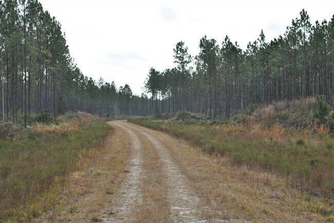
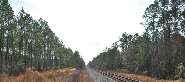
Timberlandforesttreesagricultural
Florida
PUD
1
A Areas with a 1% annual chance of flooding and a 26% chance of flooding over the life of a 30-year mortgage.
1,282.66 AC
2025
Northwest Jacksonville
2026
Jacksonville (Florida)
010601
NEARBY LISTINGS FOR SALE OR LEASE
DEMOGRAPHICS near 0 Acree Rd
1 mile
3 mile
5 mile
2025 Total Population
1,786
33,547
124,203
2030 Population
1,936
35,898
133,161
Pop Growth 2025-2030
+ 8.40%
+ 7.01%
+ 7.21%
Average Age
39
40
39
2025 Total Households
641
12,805
47,768
HH Growth 2025-2030
+ 8.58%
+ 7.27%
+ 7.47%
Median Household Inc
$56,799
$44,711
$42,491
Avg Household Size
2.70
2.50
2.50
2025 Avg HH Vehicles
2.00
2.00
1.00
Median Home Value
$257,471
$152,785
$175,025
Median Year Built
1987
1967
1967
Nearby Places
Map Layers
Map Styles
 Street
 Aerial
Transit
 Traffic
 Biking
Places
Listings with unknown addresses are not visible on the map
- Restaurants
- Banks
- Shops
- Fitness
- Groceries
PUBLIC TRANSPORTATION
COMMUTER RAIL
Jacksonville (Silver Meteor - Amtrak, Silver Star - Amtrak)
Drive
Walk
Distance
Jacksonville (Silver Meteor - Amtrak, Silver Star - Amtrak)
20 min
9.9 mi
AIRPORT
Jacksonville International
Drive
Walk
Distance
Jacksonville International
29 min
14.6 mi
Freight Ports
Jacksonville Port
Drive
Walk
Distance
Jacksonville Port
31 min
16.1 mi
SALE & LEASE HISTORY
LISTING DATE
SALE/LEASE

Feb 11, 2020
For Sale
Nearby Properties
Address
Land Use
TOTAL SIZE
Lot Size
Zoning
Address
Land Use
TOTAL SIZE
Lot Size
Zoning
79,407 SF
14.93 AC
PUD
Address
Land Use
TOTAL SIZE
Lot Size
Zoning
254.45 AC
PUD
Address
Land Use
TOTAL SIZE
Lot Size
Zoning
49,120 SF
89.32 AC
CCG-2
Address
Land Use
TOTAL SIZE
Lot Size
Zoning
1,950 SF
72.15 AC
IBP
Address
Land Use
TOTAL SIZE
Lot Size
Zoning
1,415.70 AC
AGR
Address
Land Use
TOTAL SIZE
Lot Size
Zoning
13,214 SF
1.52 AC
PUD
Address
Land Use
TOTAL SIZE
Lot Size
Zoning
2,216 SF
275.40 AC
PUD
Address
Land Use
TOTAL SIZE
Lot Size
Zoning
34,337 SF
23.09 AC
IL
Address
Land Use
TOTAL SIZE
Lot Size
Zoning
600.36 AC
AGR
Address
Land Use
TOTAL SIZE
Lot Size
Zoning
14,004 SF
10.73 AC
IH
Address
Land Use
TOTAL SIZE
Lot Size
Zoning
2,214 SF
10.97 AC
AGR
Address
Land Use
TOTAL SIZE
Lot Size
Zoning
15,693 SF
1.96 AC
CCG-1
Address
Land Use
TOTAL SIZE
Lot Size
Zoning
3,247 SF
1.06 AC
PUD
Address
Land Use
TOTAL SIZE
Lot Size
Zoning
2,390 SF
0.89 AC
PUD
Address
Land Use
TOTAL SIZE
Lot Size
Zoning
25,797 SF
22.09 AC
PUD
Address
Land Use
TOTAL SIZE
Lot Size
Zoning
44,921 SF
15.77 AC
RR-ACRE
Address
Land Use
TOTAL SIZE
Lot Size
Zoning
6,840 SF
0.85 AC
PUD
Address
Land Use
TOTAL SIZE
Lot Size
Zoning
16,880 SF
2.08 AC
CCG-2
Address
Land Use
TOTAL SIZE
Lot Size
Zoning
37.06 AC
PUD
Address
Land Use
TOTAL SIZE
Lot Size
Zoning
17,636 SF
11.15 AC
IL
Address
Land Use
TOTAL SIZE
Lot Size
Zoning
90.15 AC
AGR
Address
Land Use
TOTAL SIZE
Lot Size
Zoning
16,630 SF
6.27 AC
PUD
Address
Land Use
TOTAL SIZE
Lot Size
Zoning
4,966 SF
2.70 AC
ROS
Address
Land Use
TOTAL SIZE
Lot Size
Zoning
621.78 AC
AGR
Address
Land Use
TOTAL SIZE
Lot Size
Zoning
24,824 SF
13.31 AC
AGR
Address
Land Use
TOTAL SIZE
Lot Size
Zoning
39.06 AC
PUD
Address
Land Use
TOTAL SIZE
Lot Size
Zoning
9.28 AC
PUD
Address
Land Use
TOTAL SIZE
Lot Size
Zoning
1.99 AC
PUD
Address
Land Use
TOTAL SIZE
Lot Size
Zoning
13,559 SF
5 AC
CCG-2
Address
Land Use
TOTAL SIZE
Lot Size
Zoning
2.98 AC
AGR
The World's #1 Commercial Real Estate Marketplace
Connect with us
© 2026 CoStar Group
The information above has been obtained from sources believed reliable. While we do not doubt its accuracy we have not verified it and make no guarantee, warranty or representation about it. It is your responsibility to independently confirm its accuracy and completeness. Any projections, opinions, assumptions, or estimates used are for example only and do not represent the current or future performance of the property. The value of this transaction to you depends on tax and other factors which should be evaluated by your tax, financial, and legal advisors. You and your advisors should conduct a careful, independent investigation of the property to determine to your satisfaction the suitability of the property for your needs.