Property Record
0 Address Unassigned, Spokane Valley, WA 99206
This Property Is For Sale
NEARBY LISTINGS FOR SALE OR LEASE
Property Detail
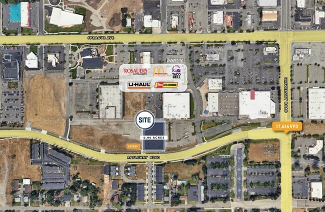
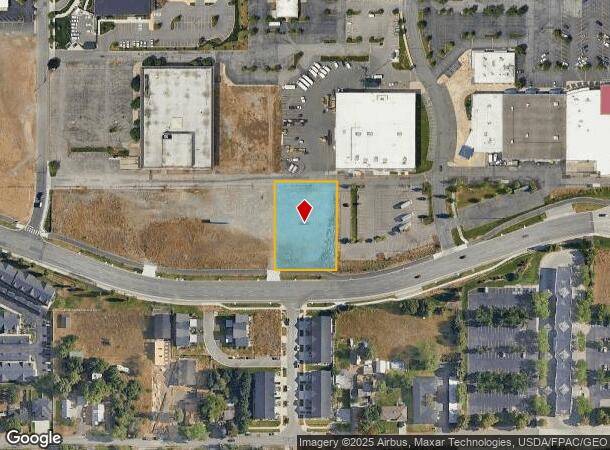
0 Address Unassigned
45201.0132
20-25-44: PARCEL 6 OF RECORD OF SURVEY AFN 6875619.
Vacantlandnec
Spokane
X
Washington
53063C0567D
0.90 AC
2025
Valley
2025
Spokane
0125003000
Spokane-Spokane Valley, WA
DEMOGRAPHICS near 0 Address Unassigned
1 Mile
3 Mile
5 Mile
2024 Total Population
12,734
79,193
150,028
2029 Population
13,568
85,239
162,177
Pop Growth 2024-2029
+ 6.55%
+ 7.63%
+ 8.10%
Average Age
40
40
40
2024 Total Households
5,063
32,170
59,186
HH Growth 2024-2029
+ 6.60%
+ 7.72%
+ 8.17%
Median Household Inc
$61,836
$61,929
$69,802
Avg Household Size
2.40
2.40
2.50
2024 Avg HH Vehicles
2.00
2.00
2.00
Median Home Value
$286,299
$313,878
$348,342
Median Year Built
1972
1976
1980
Nearby Places
- Restaurants
- Banks
- Shops
- Fitness
- Groceries
PUBLIC TRANSPORTATION
COMMUTER RAIL
Spokane (Empire Builder - Amtrak)
DRIVE
WALK
Distance
Spokane (Empire Builder - Amtrak)
15 min
7.7 mi
AIRPORT
Spokane International
DRIVE
WALK
Distance
Spokane International
23 min
13.5 mi
Freight Ports
Port of Everett
DRIVE
WALK
Distance
Port of Everett
350 min
309.1 mi
Nearby Properties
Address
Land Use
TOTAL SIZE
Lot Size
Zoning
Address
Land Use
TOTAL SIZE
Lot Size
Zoning
473,651 SF
76.70 AC
R-2
Address
Land Use
TOTAL SIZE
Lot Size
Zoning
355,192 SF
35.83 AC
I-2
Address
Land Use
TOTAL SIZE
Lot Size
Zoning
169,003 SF
5.18 AC
MUC
Address
Land Use
TOTAL SIZE
Lot Size
Zoning
259,169 SF
13.42 AC
MF-2
Address
Land Use
TOTAL SIZE
Lot Size
Zoning
318,756 SF
13.64 AC
MF-2
Address
Land Use
TOTAL SIZE
Lot Size
Zoning
378,750 SF
17.38 AC
R-2
Address
Land Use
TOTAL SIZE
Lot Size
Zoning
204,730 SF
8.60 AC
MUC
Address
Land Use
TOTAL SIZE
Lot Size
Zoning
161,130 SF
6.45 AC
GO
Address
Land Use
TOTAL SIZE
Lot Size
Zoning
240,663 SF
8.90 AC
MF-2
Address
Land Use
TOTAL SIZE
Lot Size
Zoning
84,600 SF
17.95 AC
MF-1
Address
Land Use
TOTAL SIZE
Lot Size
Zoning
136,518 SF
7.96 AC
O
Address
Land Use
TOTAL SIZE
Lot Size
Zoning
100,060 SF
14.94 AC
R-3
Address
Land Use
TOTAL SIZE
Lot Size
Zoning
175,936 SF
12.16 AC
MF-2
Address
Land Use
TOTAL SIZE
Lot Size
Zoning
69,202 SF
9.99 AC
R-2
Address
Land Use
TOTAL SIZE
Lot Size
Zoning
138,379 SF
17.39 AC
RC
Address
Land Use
TOTAL SIZE
Lot Size
Zoning
87,848 SF
7.36 AC
MF-2
Address
Land Use
TOTAL SIZE
Lot Size
Zoning
72,443 SF
8.90 AC
R-3
Address
Land Use
TOTAL SIZE
Lot Size
Zoning
126,906 SF
20.25 AC
LDR
Address
Land Use
TOTAL SIZE
Lot Size
Zoning
87,989 SF
5.38 AC
MF-2
Address
Land Use
TOTAL SIZE
Lot Size
Zoning
151,690 SF
7.89 AC
MF-2
Address
Land Use
TOTAL SIZE
Lot Size
Zoning
61,059 SF
54.20 AC
P/OS
Address
Land Use
TOTAL SIZE
Lot Size
Zoning
143,772 SF
10.67 AC
MF-2
Address
Land Use
TOTAL SIZE
Lot Size
Zoning
157,232 SF
3.28 AC
MF-2
Address
Land Use
TOTAL SIZE
Lot Size
Zoning
70,265 SF
9.64 AC
R-2
Address
Land Use
TOTAL SIZE
Lot Size
Zoning
96,424 SF
9.04 AC
I-1
Address
Land Use
TOTAL SIZE
Lot Size
Zoning
120,296 SF
9.26 AC
MF-2
Address
Land Use
TOTAL SIZE
Lot Size
Zoning
115,536 SF
6.17 AC
MUC
Address
Land Use
TOTAL SIZE
Lot Size
Zoning
139,164 SF
5.62 AC
MUC
Address
Land Use
TOTAL SIZE
Lot Size
Zoning
47,612 SF
3.38 AC
CMU
Address
Land Use
TOTAL SIZE
Lot Size
Zoning
105,659 SF
4.40 AC
MF-1
The World's #1 Commercial Real Estate Marketplace
Connect with us
© 2025 CoStar Group
The information above has been obtained from sources believed reliable. While we do not doubt its accuracy we have not verified it and make no guarantee, warranty or representation about it. It is your responsibility to independently confirm its accuracy and completeness. Any projections, opinions, assumptions, or estimates used are for example only and do not represent the current or future performance of the property. The value of this transaction to you depends on tax and other factors which should be evaluated by your tax, financial, and legal advisors. You and your advisors should conduct a careful, independent investigation of the property to determine to your satisfaction the suitability of the property for your needs.