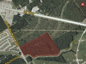
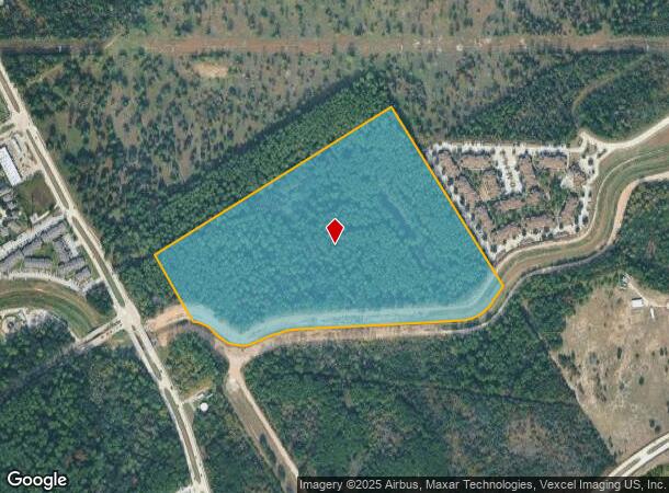
Property Record
0 Aldine Westfield Rd, Humble, TX 77338
NEARBY LISTINGS FOR SALE OR LEASE
Property Detail
0 Aldine Westfield Rd
Houston-The Woodlands-Sugar Land, TX
Abst 1542 Ht&Brr Sec 2
0480790000001
TRS 1 & 2 ABST 1542 HT&BRR SEC 2 BLK 4
Commercialacreage
Harris
AE
Texas
48339C0725G
41.63 AC
2024
Kingwood/Humble
2025
Houston
240904
DEMOGRAPHICS near 0 Aldine Westfield Rd
1 Mile
3 Mile
5 Mile
2024 Total Population
9,781
79,301
199,593
2029 Population
9,986
80,773
206,261
Pop Growth 2024-2029
+ 2.10%
+ 1.86%
+ 3.34%
Average Age
33
34
34
2024 Total Households
3,125
25,825
67,038
HH Growth 2024-2029
+ 2.08%
+ 1.89%
+ 3.31%
Median Household Inc
$57,428
$62,596
$62,174
Avg Household Size
3.10
3.00
2.90
2024 Avg HH Vehicles
2.00
2.00
2.00
Median Home Value
$160,292
$165,273
$188,096
Median Year Built
2001
1994
1997
Nearby Places
Map Layers
Map Styles
 Street
 Aerial
- Restaurants
- Banks
- Shops
- Fitness
- Groceries
PUBLIC TRANSPORTATION
AIRPORT
George Bush Intcntl/Houston
DRIVE
WALK
Distance
George Bush Intcntl/Houston
13 min
8.2 mi
William P Hobby
DRIVE
WALK
Distance
William P Hobby
49 min
32.1 mi
Freight Ports
Port of Houston
DRIVE
WALK
Distance
Port of Houston
37 min
26.1 mi
Nearby Properties
Address
Land Use
TOTAL SIZE
Lot Size
Zoning
Address
Land Use
TOTAL SIZE
Lot Size
Zoning
276,324 SF
33.79 AC
Address
Land Use
TOTAL SIZE
Lot Size
Zoning
409,480 SF
27.32 AC
Address
Land Use
TOTAL SIZE
Lot Size
Zoning
350,423 SF
122.83 AC
Address
Land Use
TOTAL SIZE
Lot Size
Zoning
280,283 SF
16.56 AC
Address
Land Use
TOTAL SIZE
Lot Size
Zoning
435,650 SF
Address
Land Use
TOTAL SIZE
Lot Size
Zoning
271,432 SF
35.81 AC
Address
Land Use
TOTAL SIZE
Lot Size
Zoning
318,000 SF
18.53 AC
Address
Land Use
TOTAL SIZE
Lot Size
Zoning
287,251 SF
18.12 AC
Address
Land Use
TOTAL SIZE
Lot Size
Zoning
288,525 SF
17.66 AC
Address
Land Use
TOTAL SIZE
Lot Size
Zoning
204,870 SF
13.40 AC
Address
Land Use
TOTAL SIZE
Lot Size
Zoning
203,013 SF
12.28 AC
Address
Land Use
TOTAL SIZE
Lot Size
Zoning
175,495 SF
8.92 AC
Address
Land Use
TOTAL SIZE
Lot Size
Zoning
267,250 SF
11.83 AC
Address
Land Use
TOTAL SIZE
Lot Size
Zoning
127,260 SF
14 AC
Address
Land Use
TOTAL SIZE
Lot Size
Zoning
159,775 SF
8.77 AC
Address
Land Use
TOTAL SIZE
Lot Size
Zoning
159,514 SF
11.40 AC
Address
Land Use
TOTAL SIZE
Lot Size
Zoning
132,102 SF
14.93 AC
Address
Land Use
TOTAL SIZE
Lot Size
Zoning
99,561 SF
11.60 AC
Address
Land Use
TOTAL SIZE
Lot Size
Zoning
199,176 SF
10.63 AC
Address
Land Use
TOTAL SIZE
Lot Size
Zoning
125,674 SF
11.56 AC
Address
Land Use
TOTAL SIZE
Lot Size
Zoning
179,748 SF
6.60 AC
Address
Land Use
TOTAL SIZE
Lot Size
Zoning
281,563 SF
19.98 AC
Address
Land Use
TOTAL SIZE
Lot Size
Zoning
186,971 SF
7.58 AC
Address
Land Use
TOTAL SIZE
Lot Size
Zoning
152,440 SF
24.67 AC
Address
Land Use
TOTAL SIZE
Lot Size
Zoning
115,000 SF
7.83 AC
Address
Land Use
TOTAL SIZE
Lot Size
Zoning
126,320 SF
12.11 AC
Address
Land Use
TOTAL SIZE
Lot Size
Zoning
98,218 SF
29.44 AC
Address
Land Use
TOTAL SIZE
Lot Size
Zoning
117,308 SF
6.90 AC
Address
Land Use
TOTAL SIZE
Lot Size
Zoning
125,476 SF
3.24 AC
Address
Land Use
TOTAL SIZE
Lot Size
Zoning
78,116 SF
6.49 AC
The World's #1 Commercial Real Estate Marketplace
Connect with us
© 2025 CoStar Group
The information above has been obtained from sources believed reliable. While we do not doubt its accuracy we have not verified it and make no guarantee, warranty or representation about it. It is your responsibility to independently confirm its accuracy and completeness. Any projections, opinions, assumptions, or estimates used are for example only and do not represent the current or future performance of the property. The value of this transaction to you depends on tax and other factors which should be evaluated by your tax, financial, and legal advisors. You and your advisors should conduct a careful, independent investigation of the property to determine to your satisfaction the suitability of the property for your needs.