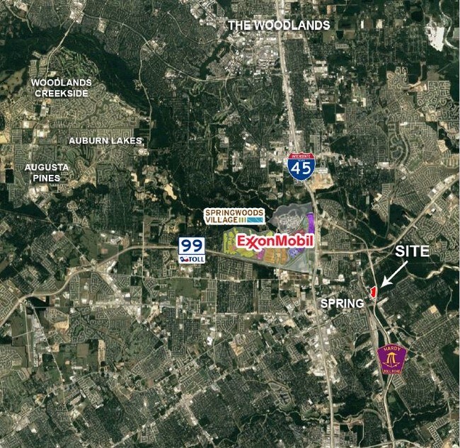
Property Record
0 Aldine Westfield Rd, Spring, TX 77373


NEARBY LISTINGS FOR SALE OR LEASE
Property Detail
0 Aldine Westfield Rd
Houston-Pasadena-The Woodlands, TX
Abst 221 H Decrow
0420750020331
TR 1F ABST 221 H DECROW
Commercialacreage
Harris
X
Texas
48339C0685G
4.58 AC
2024
FM 1960/I-45 North
2025
Houston
241101
DEMOGRAPHICS near 0 Aldine Westfield Rd
1 Mile
3 Mile
5 Mile
2024 Total Population
5,011
80,552
235,549
2029 Population
5,086
86,559
256,456
Pop Growth 2024-2029
+ 1.50%
+ 7.46%
+ 8.88%
Average Age
40
36
35
2024 Total Households
1,813
27,665
80,673
HH Growth 2024-2029
+ 1.38%
+ 7.14%
+ 8.78%
Median Household Inc
$99,210
$92,290
$79,657
Avg Household Size
2.70
2.90
2.90
2024 Avg HH Vehicles
2.00
2.00
2.00
Median Home Value
$196,652
$224,449
$233,675
Median Year Built
1996
2003
2000
Nearby Places
Map Layers
Map Styles
 Street
 Aerial
- Restaurants
- Banks
- Shops
- Fitness
- Groceries
PUBLIC TRANSPORTATION
AIRPORT
George Bush Intcntl/Houston
DRIVE
WALK
Distance
George Bush Intcntl/Houston
16 min
14.1 mi
Freight Ports
Port of Houston
DRIVE
WALK
Distance
Port of Houston
39 min
29.9 mi
SALE & LEASE HISTORY
LISTING DATE
SALE/LEASE

Mar 28, 2017
For Sale
Nearby Properties
Address
Land Use
TOTAL SIZE
Lot Size
Zoning
Address
Land Use
TOTAL SIZE
Lot Size
Zoning
6,576,138 SF
186.74 AC
Address
Land Use
TOTAL SIZE
Lot Size
Zoning
1,186,001 SF
13.27 AC
Address
Land Use
TOTAL SIZE
Lot Size
Zoning
1,004,830 SF
7.83 AC
Address
Land Use
TOTAL SIZE
Lot Size
Zoning
974,064 SF
11.79 AC
Address
Land Use
TOTAL SIZE
Lot Size
Zoning
802,274 SF
2.68 AC
Address
Land Use
TOTAL SIZE
Lot Size
Zoning
178,645 SF
8.74 AC
Address
Land Use
TOTAL SIZE
Lot Size
Zoning
970,101 SF
48.05 AC
Address
Land Use
TOTAL SIZE
Lot Size
Zoning
457,883 SF
3.74 AC
Address
Land Use
TOTAL SIZE
Lot Size
Zoning
338,220 SF
10.26 AC
Address
Land Use
TOTAL SIZE
Lot Size
Zoning
532,751 SF
6.43 AC
Address
Land Use
TOTAL SIZE
Lot Size
Zoning
314,169 SF
3.09 AC
Address
Land Use
TOTAL SIZE
Lot Size
Zoning
364,860 SF
14.96 AC
Address
Land Use
TOTAL SIZE
Lot Size
Zoning
377,266 SF
17.44 AC
Address
Land Use
TOTAL SIZE
Lot Size
Zoning
360,340 SF
14.29 AC
Address
Land Use
TOTAL SIZE
Lot Size
Zoning
373,310 SF
2.47 AC
Address
Land Use
TOTAL SIZE
Lot Size
Zoning
341,961 SF
28.25 AC
Address
Land Use
TOTAL SIZE
Lot Size
Zoning
141,454 SF
21.13 AC
Address
Land Use
TOTAL SIZE
Lot Size
Zoning
471,015 SF
6.63 AC
Address
Land Use
TOTAL SIZE
Lot Size
Zoning
397,984 SF
6.42 AC
Address
Land Use
TOTAL SIZE
Lot Size
Zoning
282,661 SF
17.81 AC
Address
Land Use
TOTAL SIZE
Lot Size
Zoning
288,721 SF
Address
Land Use
TOTAL SIZE
Lot Size
Zoning
290,353 SF
10.79 AC
Address
Land Use
TOTAL SIZE
Lot Size
Zoning
291,073 SF
11.70 AC
Address
Land Use
TOTAL SIZE
Lot Size
Zoning
331,264 SF
12.92 AC
Address
Land Use
TOTAL SIZE
Lot Size
Zoning
321,024 SF
8.73 AC
6
Address
Land Use
TOTAL SIZE
Lot Size
Zoning
136,748 SF
30.29 AC
Address
Land Use
TOTAL SIZE
Lot Size
Zoning
294,925 SF
21.79 AC
Address
Land Use
TOTAL SIZE
Lot Size
Zoning
95,649 SF
18.88 AC
Address
Land Use
TOTAL SIZE
Lot Size
Zoning
158,081 SF
23.46 AC
Address
Land Use
TOTAL SIZE
Lot Size
Zoning
216,833 SF
15.97 AC
The World's #1 Commercial Real Estate Marketplace
Connect with us
© 2026 CoStar Group
The information above has been obtained from sources believed reliable. While we do not doubt its accuracy we have not verified it and make no guarantee, warranty or representation about it. It is your responsibility to independently confirm its accuracy and completeness. Any projections, opinions, assumptions, or estimates used are for example only and do not represent the current or future performance of the property. The value of this transaction to you depends on tax and other factors which should be evaluated by your tax, financial, and legal advisors. You and your advisors should conduct a careful, independent investigation of the property to determine to your satisfaction the suitability of the property for your needs.