Property Record
Claudette, Memphis, TN 38118
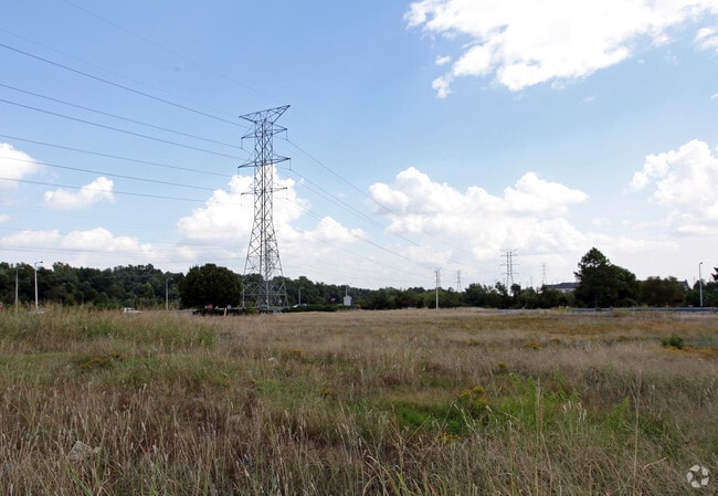
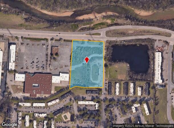
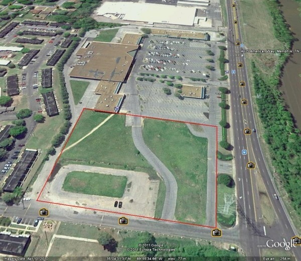

This Property Is For Sale
NEARBY LISTINGS FOR SALE OR LEASE
Property Detail
Claudette
Memphis, TN-MS-AR
American Place West Final Plan Phase Ii
07-3022-0-0326
SS AMERICAN WAY
Vacantlandnec
Shelby
X
Tennessee
47157C0435F
4.86 AC
2024
Airport
2025
Memphis
022600
DEMOGRAPHICS near Claudette
1 Mile
3 Mile
5 Mile
2024 Total Population
12,985
87,157
203,638
2029 Population
13,166
86,728
202,209
Pop Growth 2024-2029
+ 1.39%
(0.49%)
(0.70%)
Average Age
35
36
37
2024 Total Households
4,566
33,575
82,046
HH Growth 2024-2029
+ 1.82%
(0.63%)
(0.80%)
Median Household Inc
$29,760
$41,355
$45,499
Avg Household Size
2.80
2.50
2.40
2024 Avg HH Vehicles
1.00
2.00
2.00
Median Home Value
$61,873
$113,360
$183,818
Median Year Built
1967
1963
1967
Nearby Places
- Restaurants
- Banks
- Shops
- Fitness
- Groceries
PUBLIC TRANSPORTATION
COMMUTER RAIL
Central Station (Riverfront Loop - Memphis Area Transit Authority Trolley (MataTrolley))
DRIVE
WALK
Distance
Central Station (Riverfront Loop - Memphis Area Transit Authority Trolley (MataTrolley))
16 min
9.7 mi
AIRPORT
Memphis International
DRIVE
WALK
Distance
Memphis International
10 min
5.8 mi
Freight Ports
Port of Shreveport
DRIVE
WALK
Distance
Port of Shreveport
412 min
377.2 mi
Nearby Properties
Address
Land Use
TOTAL SIZE
Lot Size
Zoning
Address
Land Use
TOTAL SIZE
Lot Size
Zoning
189,536 SF
49.14 AC
CMU-2
Address
Land Use
TOTAL SIZE
Lot Size
Zoning
237,911 SF
21.38 AC
EMP
Address
Land Use
TOTAL SIZE
Lot Size
Zoning
118,116 SF
60.70 AC
CMU-2
Address
Land Use
TOTAL SIZE
Lot Size
Zoning
286,167 SF
18.91 AC
R-10
Address
Land Use
TOTAL SIZE
Lot Size
Zoning
190,263 SF
6.59 AC
R-10
Address
Land Use
TOTAL SIZE
Lot Size
Zoning
2,847.82 AC
EMP
Address
Land Use
TOTAL SIZE
Lot Size
Zoning
269,022 SF
23.76 AC
RU-3
Address
Land Use
TOTAL SIZE
Lot Size
Zoning
188,458 SF
29.19 AC
RU-3
Address
Land Use
TOTAL SIZE
Lot Size
Zoning
81,454 SF
EMP
Address
Land Use
TOTAL SIZE
Lot Size
Zoning
58.21 AC
R-6
Address
Land Use
TOTAL SIZE
Lot Size
Zoning
300,702 SF
14.40 AC
RU-3
Address
Land Use
TOTAL SIZE
Lot Size
Zoning
409,298 SF
18.94 AC
RU-1
Address
Land Use
TOTAL SIZE
Lot Size
Zoning
414,189 SF
16.71 AC
R-6
Address
Land Use
TOTAL SIZE
Lot Size
Zoning
15,370 SF
18.69 AC
RU-3
Address
Land Use
TOTAL SIZE
Lot Size
Zoning
55,250 SF
7.15 AC
CMU-3
Address
Land Use
TOTAL SIZE
Lot Size
Zoning
129 AC
CMP-1
Address
Land Use
TOTAL SIZE
Lot Size
Zoning
181.02 AC
R-15
Address
Land Use
TOTAL SIZE
Lot Size
Zoning
1,012,609 SF
38.67 AC
IH
Address
Land Use
TOTAL SIZE
Lot Size
Zoning
200,040 SF
12 AC
R-10
Address
Land Use
TOTAL SIZE
Lot Size
Zoning
369,190 SF
23.75 AC
EMP
Address
Land Use
TOTAL SIZE
Lot Size
Zoning
671,940 SF
29.38 AC
EMP
Address
Land Use
TOTAL SIZE
Lot Size
Zoning
173,089 SF
10.92 AC
EMP
Address
Land Use
TOTAL SIZE
Lot Size
Zoning
71,308 SF
EMP
Address
Land Use
TOTAL SIZE
Lot Size
Zoning
138,881 SF
9.91 AC
CMU-2
Address
Land Use
TOTAL SIZE
Lot Size
Zoning
66,841 SF
7.86 AC
CMU-3
Address
Land Use
TOTAL SIZE
Lot Size
Zoning
62,022 SF
6.28 AC
EMP
Address
Land Use
TOTAL SIZE
Lot Size
Zoning
191,168 SF
4.56 AC
CMP-1
Address
Land Use
TOTAL SIZE
Lot Size
Zoning
306,219 SF
12.11 AC
EMP
Address
Land Use
TOTAL SIZE
Lot Size
Zoning
36,148 SF
5.84 AC
R-15
Address
Land Use
TOTAL SIZE
Lot Size
Zoning
209,257 SF
39.71 AC
EMP
The World's #1 Commercial Real Estate Marketplace
Connect with us
© 2025 CoStar Group
The information above has been obtained from sources believed reliable. While we do not doubt its accuracy we have not verified it and make no guarantee, warranty or representation about it. It is your responsibility to independently confirm its accuracy and completeness. Any projections, opinions, assumptions, or estimates used are for example only and do not represent the current or future performance of the property. The value of this transaction to you depends on tax and other factors which should be evaluated by your tax, financial, and legal advisors. You and your advisors should conduct a careful, independent investigation of the property to determine to your satisfaction the suitability of the property for your needs.