Property Record
0 Avery Rd, Columbus Grove, OH 45830
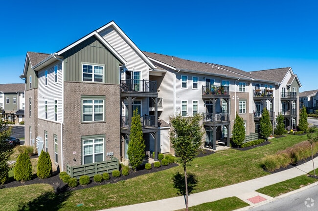

Property Detail
0 Avery Rd
010-296460
HAYDEN RUN PIKE OQ666 2/3 ENTRY 3012 19.105 ACRES
Apartment
FRANKLIN
B and X Area of moderate flood hazard, usually the area between the limits of the 100-year and 500-year floods.
Ohio
2024
19.11 AC
2025
Tuttle West
030500
Columbus
158,471 SF
Columbus, OH
NEARBY LISTINGS FOR SALE OR LEASE
DEMOGRAPHICS near 0 Avery Rd
1 mile
3 mile
5 mile
2025 Total Population
14,697
68,876
170,871
2030 Population
15,196
70,759
175,448
Pop Growth 2025-2030
+ 3.40%
+ 2.73%
+ 2.68%
Average Age
36
39
38
2025 Total Households
6,309
29,256
70,253
HH Growth 2025-2030
+ 3.42%
+ 2.75%
+ 2.76%
Median Household Inc
$89,960
$104,227
$102,940
Avg Household Size
2.30
2.30
2.40
2025 Avg HH Vehicles
2.00
2.00
2.00
Median Home Value
$352,416
$376,564
$386,746
Median Year Built
2005
1998
1993
Nearby Places
Map Layers
Map Styles
 Street
 Aerial
Layers
 Traffic
 Biking
Places
Listings with unknown addresses are not visible on the map
- Restaurants
- Banks
- Shops
- Fitness
- Groceries
PUBLIC TRANSPORTATION
AIRPORT
John Glenn Columbus International
Drive
Walk
Distance
John Glenn Columbus International
33 min
22.1 mi
Rickenbacker International
Drive
Walk
Distance
Rickenbacker International
38 min
26.7 mi
Freight Ports
Port of Toledo
Drive
Walk
Distance
Port of Toledo
175 min
127.0 mi
Nearby Properties
Address
Land Use
TOTAL SIZE
Lot Size
Zoning
Address
Land Use
TOTAL SIZE
Lot Size
Zoning
768,498 SF
55.17 AC
Address
Land Use
TOTAL SIZE
Lot Size
Zoning
464,088 SF
45.57 AC
Address
Land Use
TOTAL SIZE
Lot Size
Zoning
880,352 SF
94.89 AC
Address
Land Use
TOTAL SIZE
Lot Size
Zoning
327,525 SF
70.58 AC
Address
Land Use
TOTAL SIZE
Lot Size
Zoning
256,984 SF
10.49 AC
Address
Land Use
TOTAL SIZE
Lot Size
Zoning
529,001 SF
0.15 AC
Address
Land Use
TOTAL SIZE
Lot Size
Zoning
419,285 SF
17.19 AC
Address
Land Use
TOTAL SIZE
Lot Size
Zoning
549,907 SF
35.81 AC
Address
Land Use
TOTAL SIZE
Lot Size
Zoning
133,910 SF
14.48 AC
Address
Land Use
TOTAL SIZE
Lot Size
Zoning
46,231 SF
27.42 AC
Address
Land Use
TOTAL SIZE
Lot Size
Zoning
91,413 SF
0.14 AC
Address
Land Use
TOTAL SIZE
Lot Size
Zoning
47,334 SF
29.34 AC
Address
Land Use
TOTAL SIZE
Lot Size
Zoning
195,867 SF
14.13 AC
Address
Land Use
TOTAL SIZE
Lot Size
Zoning
110,180 SF
29.07 AC
Address
Land Use
TOTAL SIZE
Lot Size
Zoning
446,488 SF
45.12 AC
Address
Land Use
TOTAL SIZE
Lot Size
Zoning
163,895 SF
36.52 AC
Address
Land Use
TOTAL SIZE
Lot Size
Zoning
276,379 SF
14.75 AC
Address
Land Use
TOTAL SIZE
Lot Size
Zoning
67,186 SF
21.51 AC
Address
Land Use
TOTAL SIZE
Lot Size
Zoning
143,277 SF
15.54 AC
Address
Land Use
TOTAL SIZE
Lot Size
Zoning
414,372 SF
24.87 AC
Address
Land Use
TOTAL SIZE
Lot Size
Zoning
216,795 SF
10.21 AC
Address
Land Use
TOTAL SIZE
Lot Size
Zoning
226,566 SF
14.88 AC
Address
Land Use
TOTAL SIZE
Lot Size
Zoning
105,351 SF
9.88 AC
Address
Land Use
TOTAL SIZE
Lot Size
Zoning
156,030 SF
31.29 AC
Address
Land Use
TOTAL SIZE
Lot Size
Zoning
73,944 SF
11.03 AC
Address
Land Use
TOTAL SIZE
Lot Size
Zoning
21,238 SF
14.67 AC
Address
Land Use
TOTAL SIZE
Lot Size
Zoning
186,094 SF
13.06 AC
Address
Land Use
TOTAL SIZE
Lot Size
Zoning
86,067 SF
14.79 AC
Address
Land Use
TOTAL SIZE
Lot Size
Zoning
103,881 SF
11.78 AC
The World's #1 Commercial Real Estate Marketplace
Connect with us
© 2026 CoStar Group
The information above has been obtained from sources believed reliable. While we do not doubt its accuracy we have not verified it and make no guarantee, warranty or representation about it. It is your responsibility to independently confirm its accuracy and completeness. Any projections, opinions, assumptions, or estimates used are for example only and do not represent the current or future performance of the property. The value of this transaction to you depends on tax and other factors which should be evaluated by your tax, financial, and legal advisors. You and your advisors should conduct a careful, independent investigation of the property to determine to your satisfaction the suitability of the property for your needs.