Property Record
County Road 101, Pearland, TX 77584
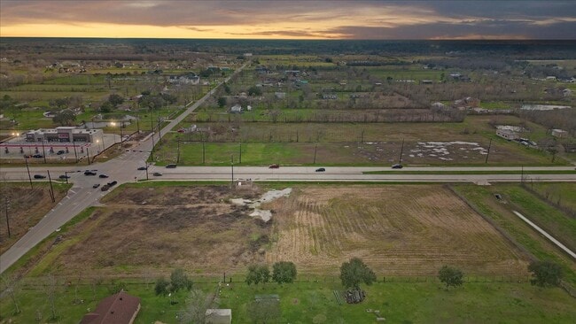

This Property Is For Sale
Property Detail
County Road 101
Houston-Pasadena-The Woodlands, TX
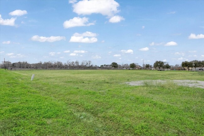
A0548 H T & B R R TRACT 44B1 (G C SMITH) ACRES 1.6974
0548-0018-111
BRAZORIA
Vacantlandnec
Texas
0052
44
B and X Area of moderate flood hazard, usually the area between the limits of the 100-year and 500-year floods.
1.70 AC
2024
South
2025
Houston
660704
NEARBY LISTINGS FOR SALE OR LEASE
DEMOGRAPHICS near County Road 101
1 mile
3 mile
5 mile
2025 Total Population
6,666
54,180
140,550
2030 Population
7,257
59,186
154,039
Pop Growth 2025-2030
+ 8.87%
+ 9.24%
+ 9.60%
Average Age
37
37
36
2025 Total Households
2,140
17,887
47,120
HH Growth 2025-2030
+ 9.16%
+ 9.43%
+ 9.79%
Median Household Inc
$124,610
$122,018
$112,042
Avg Household Size
3.00
3.00
2.90
2025 Avg HH Vehicles
2.00
2.00
2.00
Median Home Value
$366,982
$371,858
$356,109
Median Year Built
1998
2003
2004
Nearby Places
Map Layers
Map Styles
 Street
 Aerial
Layers
 Traffic
 Biking
Places
Listings with unknown addresses are not visible on the map
- Restaurants
- Banks
- Shops
- Fitness
- Groceries
PUBLIC TRANSPORTATION
AIRPORT
William P Hobby
Drive
Walk
Distance
William P Hobby
25 min
12.5 mi
George Bush Intcntl/Houston
Drive
Walk
Distance
George Bush Intcntl/Houston
51 min
36.8 mi
Freight Ports
Port of Houston
Drive
Walk
Distance
Port of Houston
35 min
20.0 mi
Nearby Properties
Address
Land Use
TOTAL SIZE
Lot Size
Zoning
Address
Land Use
TOTAL SIZE
Lot Size
Zoning
66.85 AC
0047
Address
Land Use
TOTAL SIZE
Lot Size
Zoning
367,766 SF
43.71 AC
Address
Land Use
TOTAL SIZE
Lot Size
Zoning
372,280 SF
14.70 AC
0021
Address
Land Use
TOTAL SIZE
Lot Size
Zoning
379,071 SF
20.02 AC
Address
Land Use
TOTAL SIZE
Lot Size
Zoning
321,409 SF
13.90 AC
Address
Land Use
TOTAL SIZE
Lot Size
Zoning
334,628 SF
13.87 AC
Address
Land Use
TOTAL SIZE
Lot Size
Zoning
379,493 SF
14.27 AC
Address
Land Use
TOTAL SIZE
Lot Size
Zoning
323,168 SF
12.80 AC
Address
Land Use
TOTAL SIZE
Lot Size
Zoning
240,616 SF
10.01 AC
Address
Land Use
TOTAL SIZE
Lot Size
Zoning
225,854 SF
10.44 AC
Address
Land Use
TOTAL SIZE
Lot Size
Zoning
252,472 SF
13.28 AC
Address
Land Use
TOTAL SIZE
Lot Size
Zoning
79.45 AC
1000
Address
Land Use
TOTAL SIZE
Lot Size
Zoning
16,677 SF
12.38 AC
Address
Land Use
TOTAL SIZE
Lot Size
Zoning
66,998 SF
11.34 AC
Address
Land Use
TOTAL SIZE
Lot Size
Zoning
241,488 SF
9.81 AC
Address
Land Use
TOTAL SIZE
Lot Size
Zoning
228,276 SF
9.43 AC
0036
Address
Land Use
TOTAL SIZE
Lot Size
Zoning
221,401 SF
11 AC
Address
Land Use
TOTAL SIZE
Lot Size
Zoning
344,782 SF
14.14 AC
Address
Land Use
TOTAL SIZE
Lot Size
Zoning
106,627 SF
8.40 AC
Address
Land Use
TOTAL SIZE
Lot Size
Zoning
172,256 SF
6.13 AC
Address
Land Use
TOTAL SIZE
Lot Size
Zoning
81,170 SF
50 AC
Address
Land Use
TOTAL SIZE
Lot Size
Zoning
84,604 SF
8.29 AC
0039
Address
Land Use
TOTAL SIZE
Lot Size
Zoning
58,985 SF
4.34 AC
Address
Land Use
TOTAL SIZE
Lot Size
Zoning
152,722 SF
16.70 AC
Address
Land Use
TOTAL SIZE
Lot Size
Zoning
59,618 SF
4.50 AC
Address
Land Use
TOTAL SIZE
Lot Size
Zoning
49,404 SF
1.90 AC
Address
Land Use
TOTAL SIZE
Lot Size
Zoning
210,939 SF
18.74 AC
0001
Address
Land Use
TOTAL SIZE
Lot Size
Zoning
71,700 SF
6.08 AC
Address
Land Use
TOTAL SIZE
Lot Size
Zoning
70,964 SF
6.51 AC
Address
Land Use
TOTAL SIZE
Lot Size
Zoning
106,341 SF
12.12 AC
0550
The World's #1 Commercial Real Estate Marketplace
Connect with us
© 2026 CoStar Group
The information above has been obtained from sources believed reliable. While we do not doubt its accuracy we have not verified it and make no guarantee, warranty or representation about it. It is your responsibility to independently confirm its accuracy and completeness. Any projections, opinions, assumptions, or estimates used are for example only and do not represent the current or future performance of the property. The value of this transaction to you depends on tax and other factors which should be evaluated by your tax, financial, and legal advisors. You and your advisors should conduct a careful, independent investigation of the property to determine to your satisfaction the suitability of the property for your needs.