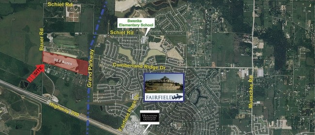
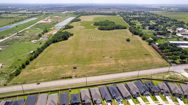
Property Record
0 Bauer Rd, Cypress, TX 77433


Property Detail
0 Bauer Rd
Houston-Pasadena-The Woodlands, TX
TR 6 ABST 585 W MCCANN
0440110000006
HARRIS
Agriculturalland
Texas
B and X Area of moderate flood hazard, usually the area between the limits of the 100-year and 500-year floods.
98.34 AC
2024
Northwest Outlier
2025
Houston
543004
NEARBY LISTINGS FOR SALE OR LEASE
DEMOGRAPHICS near 0 Bauer Rd
1 mile
3 mile
5 mile
2025 Total Population
5,325
34,431
72,021
2030 Population
5,825
37,439
78,503
Pop Growth 2025-2030
+ 9.39%
+ 8.74%
+ 9.00%
Average Age
34
35
35
2025 Total Households
1,601
10,702
22,165
HH Growth 2025-2030
+ 9.99%
+ 8.98%
+ 9.22%
Median Household Inc
$130,381
$121,805
$127,410
Avg Household Size
3.30
3.20
3.20
2025 Avg HH Vehicles
2.00
2.00
2.00
Median Home Value
$360,256
$362,756
$367,931
Median Year Built
2011
2010
2010
Nearby Places
Map Layers
Map Styles
 Street
 Aerial
Transit
 Traffic
 Biking
Places
Listings with unknown addresses are not visible on the map
- Restaurants
- Banks
- Shops
- Fitness
- Groceries
PUBLIC TRANSPORTATION
AIRPORT
George Bush Intcntl/Houston
Drive
Walk
Distance
George Bush Intcntl/Houston
47 min
33.7 mi
Freight Ports
Port of Houston
Drive
Walk
Distance
Port of Houston
57 min
42.4 mi
SALE & LEASE HISTORY
LISTING DATE
SALE/LEASE

Sep 24, 2016
For Sale
Mar 27, 2017
For Sale
Nearby Properties
Address
Land Use
TOTAL SIZE
Lot Size
Zoning
Address
Land Use
TOTAL SIZE
Lot Size
Zoning
621,523 SF
66.99 AC
Address
Land Use
TOTAL SIZE
Lot Size
Zoning
270,794 SF
30.38 AC
Address
Land Use
TOTAL SIZE
Lot Size
Zoning
297,044 SF
15 AC
Address
Land Use
TOTAL SIZE
Lot Size
Zoning
277,343 SF
12.79 AC
Address
Land Use
TOTAL SIZE
Lot Size
Zoning
290,379 SF
17.81 AC
Address
Land Use
TOTAL SIZE
Lot Size
Zoning
237,172 SF
35.93 AC
Address
Land Use
TOTAL SIZE
Lot Size
Zoning
119,152 SF
12.56 AC
Address
Land Use
TOTAL SIZE
Lot Size
Zoning
119,810 SF
14.25 AC
Address
Land Use
TOTAL SIZE
Lot Size
Zoning
81,933 SF
9.38 AC
Address
Land Use
TOTAL SIZE
Lot Size
Zoning
1,207.31 AC
Address
Land Use
TOTAL SIZE
Lot Size
Zoning
785.28 AC
Address
Land Use
TOTAL SIZE
Lot Size
Zoning
61,242 SF
30 AC
Address
Land Use
TOTAL SIZE
Lot Size
Zoning
108.28 AC
Address
Land Use
TOTAL SIZE
Lot Size
Zoning
280.90 AC
Address
Land Use
TOTAL SIZE
Lot Size
Zoning
45,632 SF
4.04 AC
Address
Land Use
TOTAL SIZE
Lot Size
Zoning
71,736 SF
5.50 AC
Address
Land Use
TOTAL SIZE
Lot Size
Zoning
568.93 AC
Address
Land Use
TOTAL SIZE
Lot Size
Zoning
34,298 SF
28.42 AC
Address
Land Use
TOTAL SIZE
Lot Size
Zoning
409.28 AC
Address
Land Use
TOTAL SIZE
Lot Size
Zoning
191,008 SF
20.47 AC
Address
Land Use
TOTAL SIZE
Lot Size
Zoning
60,800 SF
1.93 AC
Address
Land Use
TOTAL SIZE
Lot Size
Zoning
156.25 AC
Address
Land Use
TOTAL SIZE
Lot Size
Zoning
245.22 AC
Address
Land Use
TOTAL SIZE
Lot Size
Zoning
20,967 SF
2.32 AC
Address
Land Use
TOTAL SIZE
Lot Size
Zoning
73,640 SF
9.80 AC
Address
Land Use
TOTAL SIZE
Lot Size
Zoning
22,400 SF
2.94 AC
Address
Land Use
TOTAL SIZE
Lot Size
Zoning
19,950 SF
1.15 AC
Address
Land Use
TOTAL SIZE
Lot Size
Zoning
26,000 SF
2.75 AC
Address
Land Use
TOTAL SIZE
Lot Size
Zoning
157.95 AC
Address
Land Use
TOTAL SIZE
Lot Size
Zoning
28,400 SF
1.21 AC
The World's #1 Commercial Real Estate Marketplace
Connect with us
© 2026 CoStar Group
The information above has been obtained from sources believed reliable. While we do not doubt its accuracy we have not verified it and make no guarantee, warranty or representation about it. It is your responsibility to independently confirm its accuracy and completeness. Any projections, opinions, assumptions, or estimates used are for example only and do not represent the current or future performance of the property. The value of this transaction to you depends on tax and other factors which should be evaluated by your tax, financial, and legal advisors. You and your advisors should conduct a careful, independent investigation of the property to determine to your satisfaction the suitability of the property for your needs.