Property Record
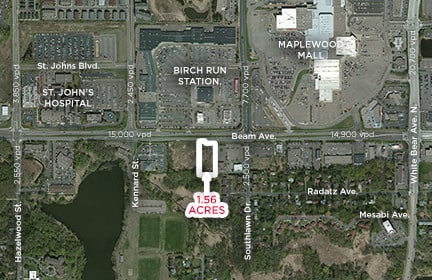
0 Beam Ave E, Maplewood, MN 55109

This Property Is For Sale
Current Lease Availabilities
Property Detail
0 Beam Ave E
Minneapolis-St. Paul-Bloomington, MN-WI
VORAN PROPERTIES ADDITION LOT 2 BLK 1
03-29-22-41-0040
RAMSEY
Commercialacreage
Minnesota
B and X Area of moderate flood hazard, usually the area between the limits of the 100-year and 500-year floods.
2
2024
1.58 AC
2025
Suburban St Paul
042401
Minneapolis/St Paul
6,580 SF
NEARBY LISTINGS FOR SALE OR LEASE
-
-
View all Maplewood listings for lease on LoopNet.com
DEMOGRAPHICS near 0 Beam Ave E
1 mile
3 mile
5 mile
2025 Total Population
6,554
76,109
224,164
2030 Population
6,564
76,435
224,545
Pop Growth 2025-2030
+ 0.15%
+ 0.43%
+ 0.17%
Average Age
42
40
39
2025 Total Households
2,776
29,305
82,894
HH Growth 2025-2030
(0.14%)
+ 0.40%
+ 0.14%
Median Household Inc
$65,281
$84,764
$80,486
Avg Household Size
2.30
2.50
2.60
2025 Avg HH Vehicles
2.00
2.00
2.00
Median Home Value
$295,446
$309,046
$303,200
Median Year Built
1989
1975
1973
Nearby Places
Map Layers
Map Styles
 Street
 Aerial
Layers
 Traffic
 Biking
Places
Listings with unknown addresses are not visible on the map
- Restaurants
- Banks
- Shops
- Fitness
- Groceries
PUBLIC TRANSPORTATION
COMMUTER RAIL
Drive
Walk
Distance
16 min
9.1 mi
AIRPORT
Minneapolis-St Paul International/Wold-Chamberlain
Drive
Walk
Distance
Minneapolis-St Paul International/Wold-Chamberlain
30 min
18.2 mi
Nearby Properties
Address
Land Use
TOTAL SIZE
Lot Size
Zoning
Address
Land Use
TOTAL SIZE
Lot Size
Zoning
187,362 SF
70.96 AC
Address
Land Use
TOTAL SIZE
Lot Size
Zoning
267,576 SF
18.95 AC
Address
Land Use
TOTAL SIZE
Lot Size
Zoning
5.59 AC
Address
Land Use
TOTAL SIZE
Lot Size
Zoning
4,800 SF
20.36 AC
Address
Land Use
TOTAL SIZE
Lot Size
Zoning
77.53 AC
Address
Land Use
TOTAL SIZE
Lot Size
Zoning
143,922 SF
23.12 AC
Address
Land Use
TOTAL SIZE
Lot Size
Zoning
250,050 SF
2.99 AC
Address
Land Use
TOTAL SIZE
Lot Size
Zoning
246,000 SF
31.03 AC
Address
Land Use
TOTAL SIZE
Lot Size
Zoning
233,419 SF
5.67 AC
Address
Land Use
TOTAL SIZE
Lot Size
Zoning
74,082 SF
12.10 AC
Address
Land Use
TOTAL SIZE
Lot Size
Zoning
90,293 SF
9.33 AC
Address
Land Use
TOTAL SIZE
Lot Size
Zoning
206,658 SF
8.21 AC
Address
Land Use
TOTAL SIZE
Lot Size
Zoning
138,407 SF
15.67 AC
Address
Land Use
TOTAL SIZE
Lot Size
Zoning
96,587 SF
17.42 AC
Address
Land Use
TOTAL SIZE
Lot Size
Zoning
Address
Land Use
TOTAL SIZE
Lot Size
Zoning
256,440 SF
27.44 AC
Address
Land Use
TOTAL SIZE
Lot Size
Zoning
1,500 SF
25.38 AC
Address
Land Use
TOTAL SIZE
Lot Size
Zoning
222,374 SF
43.99 AC
Address
Land Use
TOTAL SIZE
Lot Size
Zoning
49,691 SF
10.94 AC
Address
Land Use
TOTAL SIZE
Lot Size
Zoning
211,420 SF
5.22 AC
Address
Land Use
TOTAL SIZE
Lot Size
Zoning
17.16 AC
Address
Land Use
TOTAL SIZE
Lot Size
Zoning
212,078 SF
2.95 AC
Address
Land Use
TOTAL SIZE
Lot Size
Zoning
118,442 SF
12.83 AC
Address
Land Use
TOTAL SIZE
Lot Size
Zoning
3.91 AC
Address
Land Use
TOTAL SIZE
Lot Size
Zoning
191,844 SF
10.75 AC
Address
Land Use
TOTAL SIZE
Lot Size
Zoning
271,355 SF
20.56 AC
Address
Land Use
TOTAL SIZE
Lot Size
Zoning
126,852 SF
11.86 AC
Address
Land Use
TOTAL SIZE
Lot Size
Zoning
67,693 SF
7.30 AC
Address
Land Use
TOTAL SIZE
Lot Size
Zoning
145,458 SF
2.30 AC
Address
Land Use
TOTAL SIZE
Lot Size
Zoning
209,830 SF
10.06 AC
The World's #1 Commercial Real Estate Marketplace
Connect with us
© 2026 CoStar Group
The information above has been obtained from sources believed reliable. While we do not doubt its accuracy we have not verified it and make no guarantee, warranty or representation about it. It is your responsibility to independently confirm its accuracy and completeness. Any projections, opinions, assumptions, or estimates used are for example only and do not represent the current or future performance of the property. The value of this transaction to you depends on tax and other factors which should be evaluated by your tax, financial, and legal advisors. You and your advisors should conduct a careful, independent investigation of the property to determine to your satisfaction the suitability of the property for your needs.