Property Record
0 Bernard Rd, Jacksonville, FL 32218

Save to a Folder
{{folder.Name}}
{{folder.ListingIds.length}} Properties
{{folder.ListingIds.length}} Property
Create a New Folder
Property Detail
0 Bernard Rd
108408-0000
41-1N-27E 160.00 JOHN HOUSTON GRANT
Agriculturalland
DUVAL
PUD
Florida
A Areas with a 1% annual chance of flooding and a 26% chance of flooding over the life of a 30-year mortgage.
160.97 AC
2025
Northeast Jacksonville
2026
Jacksonville (Florida)
010308
Jacksonville, FL
NEARBY LISTINGS FOR SALE OR LEASE
DEMOGRAPHICS near 0 Bernard Rd
1 mile
3 mile
5 mile
2025 Total Population
1,780
28,420
52,828
2030 Population
1,893
30,478
56,608
Pop Growth 2025-2030
+ 6.35%
+ 7.24%
+ 7.16%
Average Age
38
38
38
2025 Total Households
620
10,182
19,541
HH Growth 2025-2030
+ 6.61%
+ 7.73%
+ 7.62%
Median Household Inc
$100,651
$99,427
$91,045
Avg Household Size
2.80
2.70
2.60
2025 Avg HH Vehicles
2.00
2.00
2.00
Median Home Value
$345,867
$346,781
$343,320
Median Year Built
2006
2006
2004
Nearby Places
Map Layers
Map Styles
 Street
 Aerial
Layers
 Traffic
 Biking
Places
Listings with unknown addresses are not visible on the map
- Restaurants
- Banks
- Shops
- Fitness
- Groceries
PUBLIC TRANSPORTATION
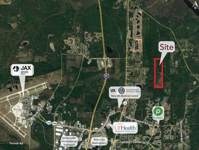
AIRPORT
Jacksonville International
Drive
Walk
Distance
Jacksonville International
16 min
7.3 mi
Freight Ports
Jacksonville Port
Drive
Walk
Distance
Jacksonville Port
25 min
12.7 mi
SALE & LEASE HISTORY
LISTING DATE
SALE/LEASE

May 20, 2022
For Sale
Apr 20, 2021
For Sale
Nearby Properties
Address
Land Use
TOTAL SIZE
Lot Size
Zoning
Address
Land Use
TOTAL SIZE
Lot Size
Zoning
344,800 SF
35.11 AC
PUD
Address
Land Use
TOTAL SIZE
Lot Size
Zoning
226,421 SF
1.89 AC
PUD
Address
Land Use
TOTAL SIZE
Lot Size
Zoning
201,630 SF
21.59 AC
PUD
Address
Land Use
TOTAL SIZE
Lot Size
Zoning
240,988 SF
18.11 AC
PUD
Address
Land Use
TOTAL SIZE
Lot Size
Zoning
210,341 SF
8.84 AC
PUD
Address
Land Use
TOTAL SIZE
Lot Size
Zoning
425,234 SF
30.18 AC
IL
Address
Land Use
TOTAL SIZE
Lot Size
Zoning
317,815 SF
17.56 AC
PUD
Address
Land Use
TOTAL SIZE
Lot Size
Zoning
163,276 SF
8.39 AC
PUD
Address
Land Use
TOTAL SIZE
Lot Size
Zoning
197,526 SF
11.98 AC
PUD
Address
Land Use
TOTAL SIZE
Lot Size
Zoning
226,572 SF
9.24 AC
PUD
Address
Land Use
TOTAL SIZE
Lot Size
Zoning
86,637 SF
8.09 AC
CCG-1
Address
Land Use
TOTAL SIZE
Lot Size
Zoning
90,363 SF
11.12 AC
PUD
Address
Land Use
TOTAL SIZE
Lot Size
Zoning
110,968 SF
5.75 AC
PUD
Address
Land Use
TOTAL SIZE
Lot Size
Zoning
28,653 SF
2.89 AC
PUD
Address
Land Use
TOTAL SIZE
Lot Size
Zoning
81,802 SF
9.34 AC
PUD
Address
Land Use
TOTAL SIZE
Lot Size
Zoning
631.55 AC
PUD
Address
Land Use
TOTAL SIZE
Lot Size
Zoning
47,065 SF
7.76 AC
CCG-2
Address
Land Use
TOTAL SIZE
Lot Size
Zoning
9,750 SF
71.20 AC
IL
Address
Land Use
TOTAL SIZE
Lot Size
Zoning
50,034 SF
8.72 AC
PUD
Address
Land Use
TOTAL SIZE
Lot Size
Zoning
24.37 AC
PUD
Address
Land Use
TOTAL SIZE
Lot Size
Zoning
56,488 SF
4.18 AC
PUD
Address
Land Use
TOTAL SIZE
Lot Size
Zoning
2,664 SF
204.15 AC
PUD
Address
Land Use
TOTAL SIZE
Lot Size
Zoning
283,827 SF
98.64 AC
IL
Address
Land Use
TOTAL SIZE
Lot Size
Zoning
26,910 SF
2.14 AC
PUD
Address
Land Use
TOTAL SIZE
Lot Size
Zoning
22,607 SF
1.95 AC
PUD
Address
Land Use
TOTAL SIZE
Lot Size
Zoning
100,800 SF
6.30 AC
CCG-1
Address
Land Use
TOTAL SIZE
Lot Size
Zoning
8,916 SF
26.61 AC
PUD
Address
Land Use
TOTAL SIZE
Lot Size
Zoning
602.71 AC
PUD
Address
Land Use
TOTAL SIZE
Lot Size
Zoning
53,506 SF
7.16 AC
RLD-70
Address
Land Use
TOTAL SIZE
Lot Size
Zoning
41,467 SF
13.91 AC
RLD-60
The World's #1 Commercial Real Estate Marketplace
Connect with us
© 2026 CoStar Group
The information above has been obtained from sources believed reliable. While we do not doubt its accuracy we have not verified it and make no guarantee, warranty or representation about it. It is your responsibility to independently confirm its accuracy and completeness. Any projections, opinions, assumptions, or estimates used are for example only and do not represent the current or future performance of the property. The value of this transaction to you depends on tax and other factors which should be evaluated by your tax, financial, and legal advisors. You and your advisors should conduct a careful, independent investigation of the property to determine to your satisfaction the suitability of the property for your needs.