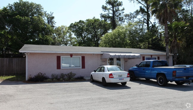
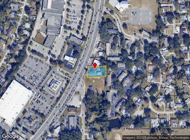
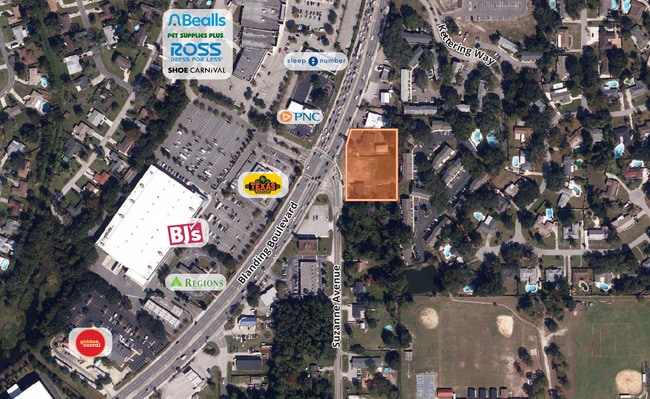
Property Record
537 Blanding Blvd, Orange Park, FL 32073
NEARBY LISTINGS FOR SALE OR LEASE
Property Detail
537 Blanding Blvd
Jacksonville, FL
Saunderlee
13-04-25-007920-000-00
PT LOT 25 BLK 2 SAUNDERLEE AS REC OR 1408 PG 2306; 1440 PG 261; 2971 PG 906,3611 PG 335,4
Officebuilding
Clay
X
Florida
12019C0090E
25
2024
0.52 AC
2025
Orange Park/Clay County
030801
Jacksonville (Florida)
2,296 SF
DEMOGRAPHICS near 537 Blanding Blvd
1 Mile
3 Mile
5 Mile
2024 Total Population
8,932
55,534
141,161
2029 Population
9,661
60,132
151,775
Pop Growth 2024-2029
+ 8.16%
+ 8.28%
+ 7.52%
Average Age
43
42
40
2024 Total Households
3,414
21,354
52,623
HH Growth 2024-2029
+ 8.23%
+ 8.33%
+ 7.60%
Median Household Inc
$79,676
$73,504
$75,543
Avg Household Size
2.60
2.50
2.60
2024 Avg HH Vehicles
2.00
2.00
2.00
Median Home Value
$237,932
$241,157
$239,501
Median Year Built
1978
1983
1991
Nearby Places
- Restaurants
- Banks
- Shops
- Fitness
- Groceries
PUBLIC TRANSPORTATION
AIRPORT
Jacksonville International
DRIVE
WALK
Distance
Jacksonville International
41 min
28.9 mi
Freight Ports
Jacksonville Port
DRIVE
WALK
Distance
Jacksonville Port
35 min
22.7 mi
SALE & LEASE HISTORY
LISTING DATE
SALE/LEASE

Oct 16, 2025
For Sale
Nearby Properties
Address
Land Use
TOTAL SIZE
Lot Size
Zoning
Address
Land Use
TOTAL SIZE
Lot Size
Zoning
721,413 SF
46.72 AC
REBS
Address
Land Use
TOTAL SIZE
Lot Size
Zoning
446,722 SF
13.26 AC
PUD
Address
Land Use
TOTAL SIZE
Lot Size
Zoning
336,253 SF
30.19 AC
PUD
Address
Land Use
TOTAL SIZE
Lot Size
Zoning
238,713 SF
53.48 AC
BB
Address
Land Use
TOTAL SIZE
Lot Size
Zoning
227,234 SF
19.99 AC
RD-4
Address
Land Use
TOTAL SIZE
Lot Size
Zoning
281,440 SF
17.01 AC
Address
Land Use
TOTAL SIZE
Lot Size
Zoning
278,173 SF
27.85 AC
Address
Land Use
TOTAL SIZE
Lot Size
Zoning
296,311 SF
20.07 AC
Address
Land Use
TOTAL SIZE
Lot Size
Zoning
234,646 SF
18.97 AC
Address
Land Use
TOTAL SIZE
Lot Size
Zoning
348,247 SF
31.85 AC
PUD
Address
Land Use
TOTAL SIZE
Lot Size
Zoning
244,004 SF
24.97 AC
PUD
Address
Land Use
TOTAL SIZE
Lot Size
Zoning
92,193 SF
20.65 AC
PUD
Address
Land Use
TOTAL SIZE
Lot Size
Zoning
33,237 SF
33.08 AC
Address
Land Use
TOTAL SIZE
Lot Size
Zoning
207,472 SF
13.39 AC
RD-4
Address
Land Use
TOTAL SIZE
Lot Size
Zoning
172,568 SF
13.15 AC
Address
Land Use
TOTAL SIZE
Lot Size
Zoning
98,675 SF
24.30 AC
Address
Land Use
TOTAL SIZE
Lot Size
Zoning
168,475 SF
9.38 AC
RD-4
Address
Land Use
TOTAL SIZE
Lot Size
Zoning
173,163 SF
18.32 AC
BSC
Address
Land Use
TOTAL SIZE
Lot Size
Zoning
159,684 SF
6.48 AC
Address
Land Use
TOTAL SIZE
Lot Size
Zoning
137,153 SF
25.85 AC
Address
Land Use
TOTAL SIZE
Lot Size
Zoning
97,584 SF
3.54 AC
CN
Address
Land Use
TOTAL SIZE
Lot Size
Zoning
182,070 SF
12.73 AC
PUD
Address
Land Use
TOTAL SIZE
Lot Size
Zoning
120,529 SF
51.50 AC
Address
Land Use
TOTAL SIZE
Lot Size
Zoning
209,568 SF
24.51 AC
PCD
Address
Land Use
TOTAL SIZE
Lot Size
Zoning
120,581 SF
13.29 AC
Address
Land Use
TOTAL SIZE
Lot Size
Zoning
37,942 SF
5.58 AC
Address
Land Use
TOTAL SIZE
Lot Size
Zoning
174,543 SF
15.91 AC
REPC
Address
Land Use
TOTAL SIZE
Lot Size
Zoning
70,693 SF
11.89 AC
Address
Land Use
TOTAL SIZE
Lot Size
Zoning
63,893 SF
5.99 AC
BB
Address
Land Use
TOTAL SIZE
Lot Size
Zoning
95,807 SF
9.91 AC
RS-2
The World's #1 Commercial Real Estate Marketplace
Connect with us
© 2025 CoStar Group
The information above has been obtained from sources believed reliable. While we do not doubt its accuracy we have not verified it and make no guarantee, warranty or representation about it. It is your responsibility to independently confirm its accuracy and completeness. Any projections, opinions, assumptions, or estimates used are for example only and do not represent the current or future performance of the property. The value of this transaction to you depends on tax and other factors which should be evaluated by your tax, financial, and legal advisors. You and your advisors should conduct a careful, independent investigation of the property to determine to your satisfaction the suitability of the property for your needs.