Property Record
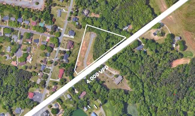
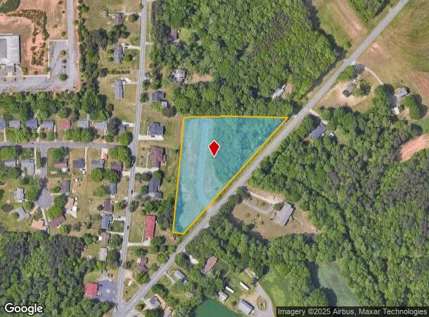
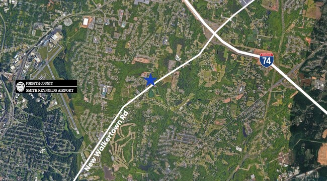
New Walkertown Rd, Winston Salem, NC 27105
This Property Is For Sale
NEARBY LISTINGS FOR SALE OR LEASE
Property Detail
New Walkertown Rd
Winston-Salem, NC
Middlefork-Two Catchall 1
6847-71-3306
LO:007N BL:3238
Residentialacreage
Forsyth
X
North Carolina
3710684700J
7n
2023
3.41 AC
2025
NE Forsyth County
001500
Greensboro/Winston-Salem
DEMOGRAPHICS near New Walkertown Rd
1 Mile
3 Mile
5 Mile
2024 Total Population
3,507
35,089
110,975
2029 Population
3,787
38,450
121,158
Pop Growth 2024-2029
+ 7.98%
+ 9.58%
+ 9.18%
Average Age
42
39
38
2024 Total Households
1,363
13,668
42,761
HH Growth 2024-2029
+ 8.36%
+ 9.91%
+ 10.00%
Median Household Inc
$58,923
$40,302
$44,906
Avg Household Size
2.50
2.50
2.30
2024 Avg HH Vehicles
2.00
2.00
2.00
Median Home Value
$145,891
$139,192
$167,806
Median Year Built
1977
1973
1975
Nearby Places
- Restaurants
- Banks
- Shops
- Fitness
- Groceries
PUBLIC TRANSPORTATION
AIRPORT
Piedmont Triad International
DRIVE
WALK
Distance
Piedmont Triad International
32 min
19.6 mi
Freight Ports
Virginia Port Authority - Richmond
DRIVE
WALK
Distance
Virginia Port Authority - Richmond
259 min
223.2 mi
Nearby Properties
Address
Land Use
TOTAL SIZE
Lot Size
Zoning
Address
Land Use
TOTAL SIZE
Lot Size
Zoning
283,831 SF
559.85 AC
GI,RS9
Address
Land Use
TOTAL SIZE
Lot Size
Zoning
373,394 SF
37.51 AC
GI
Address
Land Use
TOTAL SIZE
Lot Size
Zoning
188,273 SF
54.55 AC
IP
Address
Land Use
TOTAL SIZE
Lot Size
Zoning
1,182.87 AC
IP
Address
Land Use
TOTAL SIZE
Lot Size
Zoning
198,626 SF
31 AC
GI
Address
Land Use
TOTAL SIZE
Lot Size
Zoning
85,000 SF
48.02 AC
IP
Address
Land Use
TOTAL SIZE
Lot Size
Zoning
101,737 SF
30.14 AC
IP
Address
Land Use
TOTAL SIZE
Lot Size
Zoning
77,891 SF
20.91 AC
RS9
Address
Land Use
TOTAL SIZE
Lot Size
Zoning
66,245 SF
12.60 AC
RM12
Address
Land Use
TOTAL SIZE
Lot Size
Zoning
157,878 SF
11 AC
GI
Address
Land Use
TOTAL SIZE
Lot Size
Zoning
225,955 SF
64.68 AC
LI
Address
Land Use
TOTAL SIZE
Lot Size
Zoning
236,579 SF
18.37 AC
HB
Address
Land Use
TOTAL SIZE
Lot Size
Zoning
125,130 SF
11.23 AC
LI
Address
Land Use
TOTAL SIZE
Lot Size
Zoning
378,330 SF
74.78 AC
GI,GI-S,RS
Address
Land Use
TOTAL SIZE
Lot Size
Zoning
100 SF
12.10 AC
RM8-S
Address
Land Use
TOTAL SIZE
Lot Size
Zoning
55,106 SF
15.19 AC
IP
Address
Land Use
TOTAL SIZE
Lot Size
Zoning
15,300 SF
292.13 AC
IP,RM18,RS
Address
Land Use
TOTAL SIZE
Lot Size
Zoning
265,928 SF
30.85 AC
GI
Address
Land Use
TOTAL SIZE
Lot Size
Zoning
73,868 SF
7.35 AC
IP
Address
Land Use
TOTAL SIZE
Lot Size
Zoning
11,500 SF
139.75 AC
GI,RS9
Address
Land Use
TOTAL SIZE
Lot Size
Zoning
103,650 SF
14.06 AC
RM18
Address
Land Use
TOTAL SIZE
Lot Size
Zoning
62,331 SF
8.18 AC
IP,RS7
Address
Land Use
TOTAL SIZE
Lot Size
Zoning
75,462 SF
14.51 AC
IP
Address
Land Use
TOTAL SIZE
Lot Size
Zoning
36,345 SF
5.24 AC
LI
Address
Land Use
TOTAL SIZE
Lot Size
Zoning
131,241 SF
24.21 AC
RM18
Address
Land Use
TOTAL SIZE
Lot Size
Zoning
18,744 SF
3.28 AC
HB
Address
Land Use
TOTAL SIZE
Lot Size
Zoning
221,576 SF
39.69 AC
IP,RM12
Address
Land Use
TOTAL SIZE
Lot Size
Zoning
34,496 SF
6.26 AC
RM18
Address
Land Use
TOTAL SIZE
Lot Size
Zoning
39,445 SF
3.49 AC
IP
Address
Land Use
TOTAL SIZE
Lot Size
Zoning
42,484 SF
10.84 AC
IP-S
The World's #1 Commercial Real Estate Marketplace
Connect with us
© 2025 CoStar Group
The information above has been obtained from sources believed reliable. While we do not doubt its accuracy we have not verified it and make no guarantee, warranty or representation about it. It is your responsibility to independently confirm its accuracy and completeness. Any projections, opinions, assumptions, or estimates used are for example only and do not represent the current or future performance of the property. The value of this transaction to you depends on tax and other factors which should be evaluated by your tax, financial, and legal advisors. You and your advisors should conduct a careful, independent investigation of the property to determine to your satisfaction the suitability of the property for your needs.