Property Record
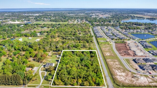
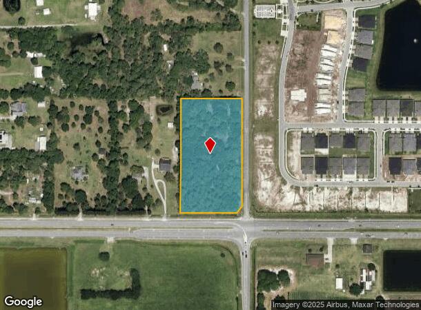
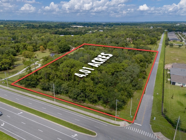
Bullis Rd, Saint Cloud, FL 34772
This Property Is For Sale
NEARBY LISTINGS FOR SALE OR LEASE
Property Detail
Bullis Rd
Orlando-Kissimmee-Sanford, FL
S L & I C
18-26-31-4950-0001-0510
S L & I C PB B PG 24 E 1/2 LOTS 51 & 62 LESS E 15 FT FOR R/W & LESS COM AT E 1/4 COR OF 18-26-31, E 1352.56 FT, N 17.50 FT TO POB; W 219.03 FT TO POC, CONC S, RAD 404.65 FT, CENT ANG 05 DEG (CH BEARING N 75 DEG W 34.23 FT), NWLY ALONG CURVE 34.24 FT,
Vacantlandnec
Osceola
X
Florida
12097C0280G
51
2024
4.01 AC
2025
Osceola Outlying
043304
Orlando
DEMOGRAPHICS near Bullis Rd
1 Mile
3 Mile
5 Mile
2024 Total Population
4,522
37,623
83,349
2029 Population
5,663
45,880
100,473
Pop Growth 2024-2029
+ 25.23%
+ 21.95%
+ 20.54%
Average Age
42
39
39
2024 Total Households
1,642
13,181
28,433
HH Growth 2024-2029
+ 25.52%
+ 21.83%
+ 20.40%
Median Household Inc
$74,829
$69,729
$69,694
Avg Household Size
2.70
2.80
2.90
2024 Avg HH Vehicles
2.00
2.00
2.00
Median Home Value
$325,932
$310,257
$307,992
Median Year Built
2010
2003
2003
Nearby Places
- Restaurants
- Banks
- Shops
- Fitness
- Groceries
PUBLIC TRANSPORTATION
AIRPORT
Orlando International
DRIVE
WALK
Distance
Orlando International
37 min
22.2 mi
Freight Ports
Port Canaveral
DRIVE
WALK
Distance
Port Canaveral
75 min
56.1 mi
Nearby Properties
Address
Land Use
TOTAL SIZE
Lot Size
Zoning
Address
Land Use
TOTAL SIZE
Lot Size
Zoning
313,120 SF
54.86 AC
SP
Address
Land Use
TOTAL SIZE
Lot Size
Zoning
185,953 SF
63.41 AC
SP
Address
Land Use
TOTAL SIZE
Lot Size
Zoning
77,928 SF
24.79 AC
SHB
Address
Land Use
TOTAL SIZE
Lot Size
Zoning
127,960 SF
14.40 AC
SPUD
Address
Land Use
TOTAL SIZE
Lot Size
Zoning
55,521 SF
10.75 AC
SHB
Address
Land Use
TOTAL SIZE
Lot Size
Zoning
89,482 SF
4.82 AC
SPUD
Address
Land Use
TOTAL SIZE
Lot Size
Zoning
13.38 AC
Address
Land Use
TOTAL SIZE
Lot Size
Zoning
60,211 SF
6.46 AC
SPUD
Address
Land Use
TOTAL SIZE
Lot Size
Zoning
44,380 SF
7.84 AC
SHB
Address
Land Use
TOTAL SIZE
Lot Size
Zoning
70,375 SF
4.58 AC
OAR2
Address
Land Use
TOTAL SIZE
Lot Size
Zoning
57,600 SF
4.83 AC
SHB
Address
Land Use
TOTAL SIZE
Lot Size
Zoning
13,900 SF
3.90 AC
SI3
Address
Land Use
TOTAL SIZE
Lot Size
Zoning
50,570 SF
4.98 AC
SPUD
Address
Land Use
TOTAL SIZE
Lot Size
Zoning
14,234 SF
1.79 AC
SHB
Address
Land Use
TOTAL SIZE
Lot Size
Zoning
68,472 SF
0.80 AC
SCB1
Address
Land Use
TOTAL SIZE
Lot Size
Zoning
23,000 SF
3.09 AC
SI3
Address
Land Use
TOTAL SIZE
Lot Size
Zoning
73.74 AC
OAC
Address
Land Use
TOTAL SIZE
Lot Size
Zoning
48,306 SF
3.13 AC
SHB
Address
Land Use
TOTAL SIZE
Lot Size
Zoning
4,308 SF
1.84 AC
RM-2
Address
Land Use
TOTAL SIZE
Lot Size
Zoning
46,404 SF
29.13 AC
SP
Address
Land Use
TOTAL SIZE
Lot Size
Zoning
50,442 SF
13.86 AC
E-1
Address
Land Use
TOTAL SIZE
Lot Size
Zoning
35,838 SF
20.56 AC
SA
Address
Land Use
TOTAL SIZE
Lot Size
Zoning
13,712 SF
1.06 AC
SNB
Address
Land Use
TOTAL SIZE
Lot Size
Zoning
44,565 SF
7 AC
AC
Address
Land Use
TOTAL SIZE
Lot Size
Zoning
5,755 SF
1.76 AC
SHB
Address
Land Use
TOTAL SIZE
Lot Size
Zoning
31,640 SF
2.04 AC
SI3
Address
Land Use
TOTAL SIZE
Lot Size
Zoning
31,430 SF
2.07 AC
SI3
Address
Land Use
TOTAL SIZE
Lot Size
Zoning
1,104 SF
11.77 AC
OCG
Address
Land Use
TOTAL SIZE
Lot Size
Zoning
42,412 SF
6.30 AC
Address
Land Use
TOTAL SIZE
Lot Size
Zoning
25,232 SF
254.03 AC
SAC
The World's #1 Commercial Real Estate Marketplace
Connect with us
© 2025 CoStar Group
The information above has been obtained from sources believed reliable. While we do not doubt its accuracy we have not verified it and make no guarantee, warranty or representation about it. It is your responsibility to independently confirm its accuracy and completeness. Any projections, opinions, assumptions, or estimates used are for example only and do not represent the current or future performance of the property. The value of this transaction to you depends on tax and other factors which should be evaluated by your tax, financial, and legal advisors. You and your advisors should conduct a careful, independent investigation of the property to determine to your satisfaction the suitability of the property for your needs.