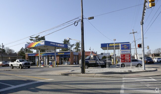
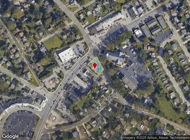
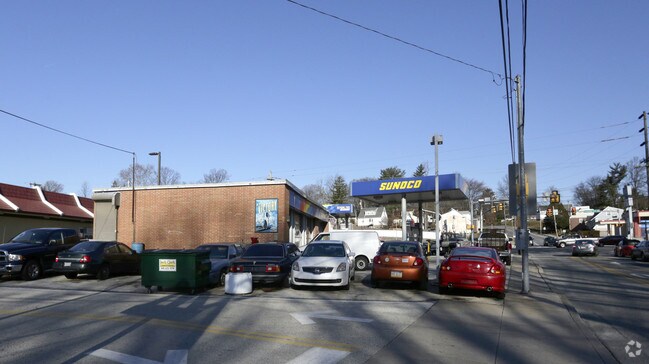
Property Record
0 Burmont Rd, Drexel Hill, PA 19026
NEARBY LISTINGS FOR SALE OR LEASE
Property Detail
0 Burmont Rd
16-11-01881-00
1 STY SERVICE STATION 54.96 X 141.74
Servicestation
Delaware
X
Pennsylvania
42045C0104F
0.26 AC
2024
Delaware County
2025
Philadelphia
401302
Philadelphia-Camden-Wilmington, PA-NJ-DE-MD
1,992 SF
DEMOGRAPHICS near 0 Burmont Rd
1 Mile
3 Mile
5 Mile
2024 Total Population
18,683
160,034
485,351
2029 Population
18,490
157,833
478,965
Pop Growth 2024-2029
(1.03%)
(1.38%)
(1.32%)
Average Age
41
40
40
2024 Total Households
7,327
59,846
184,787
HH Growth 2024-2029
(1.21%)
(1.43%)
(1.39%)
Median Household Inc
$90,314
$88,082
$70,764
Avg Household Size
2.50
2.60
2.50
2024 Avg HH Vehicles
2.00
2.00
1.00
Median Home Value
$308,459
$301,798
$261,051
Median Year Built
1951
1951
1950
Nearby Places
Map Layers
Map Styles
 Street
 Aerial
- Restaurants
- Banks
- Shops
- Fitness
- Groceries
PUBLIC TRANSPORTATION
TRANSIT/SUBWAY
Anderson Avenue (Route 101 - SEPTA)
DRIVE
WALK
Distance
Anderson Avenue (Route 101 - SEPTA)
3 min
15 min
0.8 mi
Drexelbrook (Route 101 - SEPTA)
DRIVE
WALK
Distance
Drexelbrook (Route 101 - SEPTA)
3 min
19 min
1.0 mi
Aronimink (Route 101 - SEPTA)
DRIVE
WALK
Distance
Aronimink (Route 101 - SEPTA)
3 min
19 min
1.0 mi
COMMUTER RAIL
Clifton-Aldan (Route 102 - Southeastern Pennsylvania Transportation Authority Rapid Transit (SEPTA Subway & Trolley))
DRIVE
WALK
Distance
Clifton-Aldan (Route 102 - Southeastern Pennsylvania Transportation Authority Rapid Transit (SEPTA Subway & Trolley))
10 min
4.0 mi
Clifton-Aldan (R3 - Southeastern Pennsylvania Transportation Authority Regional Rail (SEPTA Regional Rail))
DRIVE
WALK
Distance
Clifton-Aldan (R3 - Southeastern Pennsylvania Transportation Authority Regional Rail (SEPTA Regional Rail))
10 min
4.0 mi
AIRPORT
Philadelphia International
DRIVE
WALK
Distance
Philadelphia International
24 min
13.9 mi
Freight Ports
South Jersey Port
DRIVE
WALK
Distance
South Jersey Port
30 min
13.8 mi
Nearby Properties
Address
Land Use
TOTAL SIZE
Lot Size
Zoning
Address
Land Use
TOTAL SIZE
Lot Size
Zoning
158,496 SF
Address
Land Use
TOTAL SIZE
Lot Size
Zoning
59,126 SF
84.57 AC
Address
Land Use
TOTAL SIZE
Lot Size
Zoning
15,660 SF
56.60 AC
Address
Land Use
TOTAL SIZE
Lot Size
Zoning
448,864 SF
32.89 AC
Address
Land Use
TOTAL SIZE
Lot Size
Zoning
48,739 SF
30 AC
Address
Land Use
TOTAL SIZE
Lot Size
Zoning
90,784 SF
26.26 AC
Address
Land Use
TOTAL SIZE
Lot Size
Zoning
112,268 SF
28.27 AC
Address
Land Use
TOTAL SIZE
Lot Size
Zoning
82,153 SF
13.97 AC
Address
Land Use
TOTAL SIZE
Lot Size
Zoning
702,532 SF
11 AC
Address
Land Use
TOTAL SIZE
Lot Size
Zoning
20,880 SF
27.20 AC
Address
Land Use
TOTAL SIZE
Lot Size
Zoning
6,040 SF
16.45 AC
Address
Land Use
TOTAL SIZE
Lot Size
Zoning
136,972 SF
27 AC
Address
Land Use
TOTAL SIZE
Lot Size
Zoning
30,204 SF
13.75 AC
Address
Land Use
TOTAL SIZE
Lot Size
Zoning
131,980 SF
9.17 AC
Address
Land Use
TOTAL SIZE
Lot Size
Zoning
114,058 SF
3.20 AC
Address
Land Use
TOTAL SIZE
Lot Size
Zoning
261,618 SF
30.57 AC
Address
Land Use
TOTAL SIZE
Lot Size
Zoning
69,420 SF
17.12 AC
Address
Land Use
TOTAL SIZE
Lot Size
Zoning
282,520 SF
24.44 AC
Address
Land Use
TOTAL SIZE
Lot Size
Zoning
86,052 SF
7.63 AC
Address
Land Use
TOTAL SIZE
Lot Size
Zoning
Address
Land Use
TOTAL SIZE
Lot Size
Zoning
72,564 SF
24.44 AC
Address
Land Use
TOTAL SIZE
Lot Size
Zoning
60,588 SF
9.43 AC
Address
Land Use
TOTAL SIZE
Lot Size
Zoning
33,326 SF
7.73 AC
Address
Land Use
TOTAL SIZE
Lot Size
Zoning
140,426 SF
10.46 AC
Address
Land Use
TOTAL SIZE
Lot Size
Zoning
100,242 SF
5 AC
Address
Land Use
TOTAL SIZE
Lot Size
Zoning
90,368 SF
124 AC
Address
Land Use
TOTAL SIZE
Lot Size
Zoning
152,403 SF
16.98 AC
Address
Land Use
TOTAL SIZE
Lot Size
Zoning
91,216 SF
5.99 AC
CA2
Address
Land Use
TOTAL SIZE
Lot Size
Zoning
171,081 SF
25.30 AC
Address
Land Use
TOTAL SIZE
Lot Size
Zoning
22,786 SF
5.30 AC
The World's #1 Commercial Real Estate Marketplace
Connect with us
© 2025 CoStar Group
The information above has been obtained from sources believed reliable. While we do not doubt its accuracy we have not verified it and make no guarantee, warranty or representation about it. It is your responsibility to independently confirm its accuracy and completeness. Any projections, opinions, assumptions, or estimates used are for example only and do not represent the current or future performance of the property. The value of this transaction to you depends on tax and other factors which should be evaluated by your tax, financial, and legal advisors. You and your advisors should conduct a careful, independent investigation of the property to determine to your satisfaction the suitability of the property for your needs.