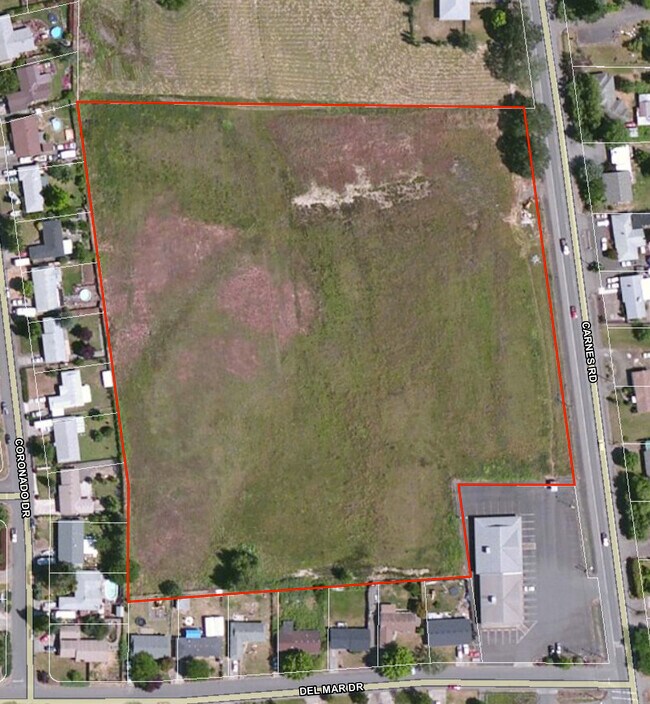
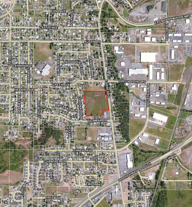
Property Record
0 Carnes Rd, Roseburg, OR 97471

Property Detail
0 Carnes Rd
R36601
P.P. 1993-11, PARCEL 2, ACRES 9.08
Multifamilyacreage
DOUGLAS
R2
Oregon
B and X Area of moderate flood hazard, usually the area between the limits of the 100-year and 500-year floods.
2
2025
9.08 AC
2025
Other Market Areas
080002
Roseburg, OR
NEARBY LISTINGS FOR SALE OR LEASE
DEMOGRAPHICS near 0 Carnes Rd
1 mile
3 mile
5 mile
2024 Total Population
7,408
14,861
31,601
2029 Population
7,654
15,263
32,661
Pop Growth 2024-2029
+ 3.32%
+ 2.71%
+ 3.35%
Average Age
41
42
42
2024 Total Households
2,800
5,779
12,697
HH Growth 2024-2029
+ 3.29%
+ 2.66%
+ 3.42%
Median Household Inc
$63,930
$59,999
$50,776
Avg Household Size
2.60
2.50
2.40
2024 Avg HH Vehicles
2.00
2.00
2.00
Median Home Value
$233,741
$242,066
$257,812
Median Year Built
1988
1985
1978
Nearby Places
Map Layers
Map Styles
 Street
 Aerial
Transit
 Traffic
 Biking
Places
Listings with unknown addresses are not visible on the map
- Restaurants
- Banks
- Shops
- Fitness
- Groceries
SALE & LEASE HISTORY
LISTING DATE
SALE/LEASE

Jun 14, 2021
For Sale
Nearby Properties
Address
Land Use
TOTAL SIZE
Lot Size
Zoning
Address
Land Use
TOTAL SIZE
Lot Size
Zoning
5 AC
PR
Address
Land Use
TOTAL SIZE
Lot Size
Zoning
40 AC
M3
Address
Land Use
TOTAL SIZE
Lot Size
Zoning
13.73 AC
M2
Address
Land Use
TOTAL SIZE
Lot Size
Zoning
35.26 AC
PR
Address
Land Use
TOTAL SIZE
Lot Size
Zoning
5,598 SF
349.39 AC
A-O
Address
Land Use
TOTAL SIZE
Lot Size
Zoning
8,698 SF
14.50 AC
C3
Address
Land Use
TOTAL SIZE
Lot Size
Zoning
5 AC
M3
Address
Land Use
TOTAL SIZE
Lot Size
Zoning
440 SF
64.40 AC
PR
Address
Land Use
TOTAL SIZE
Lot Size
Zoning
72,436 SF
9.70 AC
M2
Address
Land Use
TOTAL SIZE
Lot Size
Zoning
40.01 AC
M3
Address
Land Use
TOTAL SIZE
Lot Size
Zoning
16,991 SF
7.25 AC
PR
Address
Land Use
TOTAL SIZE
Lot Size
Zoning
11.31 AC
PR
Address
Land Use
TOTAL SIZE
Lot Size
Zoning
13.05 AC
PR
Address
Land Use
TOTAL SIZE
Lot Size
Zoning
35,824 SF
3.82 AC
C2
Address
Land Use
TOTAL SIZE
Lot Size
Zoning
35,350 SF
2.06 AC
CG
Address
Land Use
TOTAL SIZE
Lot Size
Zoning
39.70 AC
M3
Address
Land Use
TOTAL SIZE
Lot Size
Zoning
41,124 SF
4.11 AC
CG
Address
Land Use
TOTAL SIZE
Lot Size
Zoning
9.81 AC
Address
Land Use
TOTAL SIZE
Lot Size
Zoning
45,336 SF
3.72 AC
RH
Address
Land Use
TOTAL SIZE
Lot Size
Zoning
252.09 AC
CH
Address
Land Use
TOTAL SIZE
Lot Size
Zoning
1,008 SF
15.27 AC
M3
Address
Land Use
TOTAL SIZE
Lot Size
Zoning
6.52 AC
PR
Address
Land Use
TOTAL SIZE
Lot Size
Zoning
1,024 SF
9.48 AC
PR
Address
Land Use
TOTAL SIZE
Lot Size
Zoning
19,218 SF
0.79 AC
CG
Address
Land Use
TOTAL SIZE
Lot Size
Zoning
22.59 AC
M3
Address
Land Use
TOTAL SIZE
Lot Size
Zoning
39,064 SF
3.43 AC
C3
Address
Land Use
TOTAL SIZE
Lot Size
Zoning
7.02 AC
M2
Address
Land Use
TOTAL SIZE
Lot Size
Zoning
9,862 SF
5 AC
FF
Address
Land Use
TOTAL SIZE
Lot Size
Zoning
Address
Land Use
TOTAL SIZE
Lot Size
Zoning
9.82 AC
M2
The World's #1 Commercial Real Estate Marketplace
Connect with us
© 2026 CoStar Group
The information above has been obtained from sources believed reliable. While we do not doubt its accuracy we have not verified it and make no guarantee, warranty or representation about it. It is your responsibility to independently confirm its accuracy and completeness. Any projections, opinions, assumptions, or estimates used are for example only and do not represent the current or future performance of the property. The value of this transaction to you depends on tax and other factors which should be evaluated by your tax, financial, and legal advisors. You and your advisors should conduct a careful, independent investigation of the property to determine to your satisfaction the suitability of the property for your needs.