Property Record
29 Cedar Way, Youngsville, NC 27596
NEARBY LISTINGS FOR SALE OR LEASE
Property Detail
29 Cedar Way
Raleigh, NC
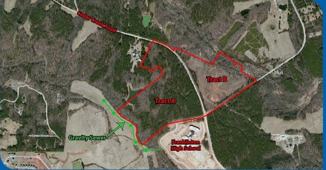
Hudson Tract
004901
ADJ/ACCESS NOT SURE HOW MUCH OF THIS LAND SPLIT TO FRANKLIN FARMS S/D
Sfr
Franklin
X
North Carolina
3720185200J
a
2025
2 AC
2025
Franklin County
060301
Raleigh/Durham
1,564 SF
DEMOGRAPHICS near 29 Cedar Way
1 Mile
3 Mile
5 Mile
2024 Total Population
1,758
12,688
25,676
2029 Population
2,203
15,794
31,719
Pop Growth 2024-2029
+ 25.31%
+ 24.48%
+ 23.54%
Average Age
38
39
39
2024 Total Households
667
4,768
9,693
HH Growth 2024-2029
+ 25.34%
+ 24.43%
+ 23.48%
Median Household Inc
$57,036
$69,302
$70,690
Avg Household Size
2.60
2.60
2.60
2024 Avg HH Vehicles
2.00
2.00
2.00
Median Home Value
$204,483
$234,926
$254,430
Median Year Built
2002
2003
2002
Nearby Places
Map Layers
Map Styles
 Street
 Aerial
- Restaurants
- Banks
- Shops
- Fitness
- Groceries
PUBLIC TRANSPORTATION
AIRPORT
Raleigh-Durham International
DRIVE
WALK
Distance
Raleigh-Durham International
41 min
26.5 mi
Freight Ports
Virginia Port Authority - Richmond
DRIVE
WALK
Distance
Virginia Port Authority - Richmond
156 min
130.8 mi
SALE & LEASE HISTORY
LISTING DATE
SALE/LEASE

Sep 24, 2016
For Sale
Nearby Properties
Address
Land Use
TOTAL SIZE
Lot Size
Zoning
Address
Land Use
TOTAL SIZE
Lot Size
Zoning
159,584 SF
67.12 AC
FCO GB
Address
Land Use
TOTAL SIZE
Lot Size
Zoning
136,644 SF
4.38 AC
RMX
Address
Land Use
TOTAL SIZE
Lot Size
Zoning
143,060 SF
7.19 AC
RMX
Address
Land Use
TOTAL SIZE
Lot Size
Zoning
216,580 SF
14.99 AC
FCO GB
Address
Land Use
TOTAL SIZE
Lot Size
Zoning
170,100 SF
15.41 AC
FCO GB
Address
Land Use
TOTAL SIZE
Lot Size
Zoning
102,946 SF
43.23 AC
FCO GB
Address
Land Use
TOTAL SIZE
Lot Size
Zoning
20,981 SF
30.74 AC
FCO GB
Address
Land Use
TOTAL SIZE
Lot Size
Zoning
117,680 SF
11.99 AC
GR10
Address
Land Use
TOTAL SIZE
Lot Size
Zoning
160,525 SF
20.02 AC
IND
Address
Land Use
TOTAL SIZE
Lot Size
Zoning
58,211 SF
6.96 AC
NMX
Address
Land Use
TOTAL SIZE
Lot Size
Zoning
364,500 SF
30.25 AC
IND
Address
Land Use
TOTAL SIZE
Lot Size
Zoning
105,912 SF
8.44 AC
GR10
Address
Land Use
TOTAL SIZE
Lot Size
Zoning
81,604 SF
17.53 AC
CIVIC
Address
Land Use
TOTAL SIZE
Lot Size
Zoning
65,837 SF
30 AC
M U
Address
Land Use
TOTAL SIZE
Lot Size
Zoning
148,249 SF
8.45 AC
L I
Address
Land Use
TOTAL SIZE
Lot Size
Zoning
28,756 SF
100.63 AC
FCO GB
Address
Land Use
TOTAL SIZE
Lot Size
Zoning
34,176 SF
12.93 AC
CU-1
Address
Land Use
TOTAL SIZE
Lot Size
Zoning
53,072 SF
20.91 AC
FCO GB
Address
Land Use
TOTAL SIZE
Lot Size
Zoning
112,694 SF
6.85 AC
M U
Address
Land Use
TOTAL SIZE
Lot Size
Zoning
73,722 SF
23.98 AC
IND
Address
Land Use
TOTAL SIZE
Lot Size
Zoning
880 SF
88.02 AC
MU-2
Address
Land Use
TOTAL SIZE
Lot Size
Zoning
63,930 SF
17.06 AC
CIVIC
Address
Land Use
TOTAL SIZE
Lot Size
Zoning
119,496 SF
6.97 AC
L I
Address
Land Use
TOTAL SIZE
Lot Size
Zoning
117,140 SF
8.62 AC
M U
Address
Land Use
TOTAL SIZE
Lot Size
Zoning
189,896 SF
10.01 AC
L I
Address
Land Use
TOTAL SIZE
Lot Size
Zoning
79,369 SF
4.62 AC
L I
Address
Land Use
TOTAL SIZE
Lot Size
Zoning
100,985 SF
10 AC
M U
Address
Land Use
TOTAL SIZE
Lot Size
Zoning
53.73 AC
IND
Address
Land Use
TOTAL SIZE
Lot Size
Zoning
79,560 SF
9.43 AC
IND
Address
Land Use
TOTAL SIZE
Lot Size
Zoning
35,519 SF
15.46 AC
CIVIC
The World's #1 Commercial Real Estate Marketplace
Connect with us
© 2026 CoStar Group
The information above has been obtained from sources believed reliable. While we do not doubt its accuracy we have not verified it and make no guarantee, warranty or representation about it. It is your responsibility to independently confirm its accuracy and completeness. Any projections, opinions, assumptions, or estimates used are for example only and do not represent the current or future performance of the property. The value of this transaction to you depends on tax and other factors which should be evaluated by your tax, financial, and legal advisors. You and your advisors should conduct a careful, independent investigation of the property to determine to your satisfaction the suitability of the property for your needs.