Property Record
4180 Chamblee Rd, Oakwood, GA 30566


Save to a Folder
{{folder.Name}}
{{folder.ListingIds.length}} Properties
{{folder.ListingIds.length}} Property
Create a New Folder
This Property Is For Sale
Property Detail
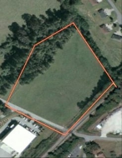
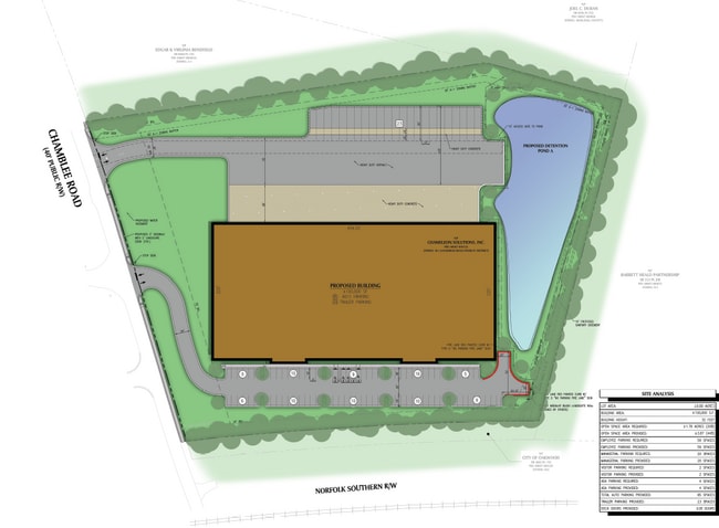
4180 Chamblee Rd
08-00067-00-123
CHAMBLEE ROAD
Industrialacreage
HALL
M-1
Georgia
B and X Area of moderate flood hazard, usually the area between the limits of the 100-year and 500-year floods.
8.88 AC
2025
Gainesville/Hall County
2025
Atlanta
001405
Gainesville, GA
NEARBY LISTINGS FOR SALE OR LEASE
DEMOGRAPHICS near 4180 Chamblee Rd
1 mile
3 mile
5 mile
2025 Total Population
2,147
32,375
73,648
2030 Population
2,375
35,504
79,976
Pop Growth 2025-2030
+ 10.62%
+ 9.66%
+ 8.59%
Average Age
36
39
39
2025 Total Households
784
12,072
26,062
HH Growth 2025-2030
+ 10.71%
+ 9.75%
+ 8.74%
Median Household Inc
$65,911
$81,177
$84,981
Avg Household Size
2.70
2.60
2.80
2025 Avg HH Vehicles
2.00
2.00
2.00
Median Home Value
$332,069
$341,535
$362,502
Median Year Built
1990
2001
1998
Nearby Places
Map Layers
Map Styles
 Street
 Aerial
Layers
 Traffic
 Biking
Places
Listings with unknown addresses are not visible on the map
- Restaurants
- Banks
- Shops
- Fitness
- Groceries
PUBLIC TRANSPORTATION
COMMUTER RAIL
Gainesville Amtrak Station (Crescent - Amtrak)
Drive
Walk
Distance
Gainesville Amtrak Station (Crescent - Amtrak)
14 min
8.6 mi
Freight Ports
Georgia Ports - Savannah
Drive
Walk
Distance
Georgia Ports - Savannah
324 min
255.7 mi
Nearby Properties
Address
Land Use
TOTAL SIZE
Lot Size
Zoning
Address
Land Use
TOTAL SIZE
Lot Size
Zoning
5,760 SF
38.07 AC
R-III
Address
Land Use
TOTAL SIZE
Lot Size
Zoning
102,060 SF
31.90 AC
R-1I/H-B
Address
Land Use
TOTAL SIZE
Lot Size
Zoning
164,815 SF
29.93 AC
R-IV
Address
Land Use
TOTAL SIZE
Lot Size
Zoning
150,738 SF
43.34 AC
M-1
Address
Land Use
TOTAL SIZE
Lot Size
Zoning
656,200 SF
70.29 AC
M-1
Address
Land Use
TOTAL SIZE
Lot Size
Zoning
112,734 SF
32.02 AC
R-4
Address
Land Use
TOTAL SIZE
Lot Size
Zoning
92,448 SF
24.25 AC
PUD
Address
Land Use
TOTAL SIZE
Lot Size
Zoning
144,744 SF
35.47 AC
C-2
Address
Land Use
TOTAL SIZE
Lot Size
Zoning
3,881 SF
27.86 AC
R-IV
Address
Land Use
TOTAL SIZE
Lot Size
Zoning
45,900 SF
6.99 AC
PRD
Address
Land Use
TOTAL SIZE
Lot Size
Zoning
342,720 SF
22.95 AC
PUD
Address
Land Use
TOTAL SIZE
Lot Size
Zoning
447,120 SF
35 AC
M-1
Address
Land Use
TOTAL SIZE
Lot Size
Zoning
174,720 SF
50.23 AC
M-2
Address
Land Use
TOTAL SIZE
Lot Size
Zoning
351,550 SF
26.91 AC
M-2
Address
Land Use
TOTAL SIZE
Lot Size
Zoning
104,340 SF
42.22 AC
INST
Address
Land Use
TOTAL SIZE
Lot Size
Zoning
277,684 SF
23.06 AC
L-I
Address
Land Use
TOTAL SIZE
Lot Size
Zoning
175,622 SF
20.22 AC
M-2
Address
Land Use
TOTAL SIZE
Lot Size
Zoning
304,844 SF
37.58 AC
M-2
Address
Land Use
TOTAL SIZE
Lot Size
Zoning
1,580 SF
15.85 AC
PUD
Address
Land Use
TOTAL SIZE
Lot Size
Zoning
269,130 SF
25.34 AC
M-1
Address
Land Use
TOTAL SIZE
Lot Size
Zoning
225,378 SF
24.42 AC
M-1
Address
Land Use
TOTAL SIZE
Lot Size
Zoning
515,468 SF
92 AC
I-1
Address
Land Use
TOTAL SIZE
Lot Size
Zoning
3,195 SF
80.04 AC
AR-1
Address
Land Use
TOTAL SIZE
Lot Size
Zoning
213,480 SF
13.16 AC
M-1
Address
Land Use
TOTAL SIZE
Lot Size
Zoning
255,201 SF
21.75 AC
M-1
Address
Land Use
TOTAL SIZE
Lot Size
Zoning
172,114 SF
43.32 AC
M-2
Address
Land Use
TOTAL SIZE
Lot Size
Zoning
192,177 SF
12.43 AC
PRD
Address
Land Use
TOTAL SIZE
Lot Size
Zoning
183,700 SF
19.94 AC
M-1
Address
Land Use
TOTAL SIZE
Lot Size
Zoning
58.61 AC
INST
Address
Land Use
TOTAL SIZE
Lot Size
Zoning
201,322 SF
10 AC
M-1
The World's #1 Commercial Real Estate Marketplace
Connect with us
© 2026 CoStar Group
The information above has been obtained from sources believed reliable. While we do not doubt its accuracy we have not verified it and make no guarantee, warranty or representation about it. It is your responsibility to independently confirm its accuracy and completeness. Any projections, opinions, assumptions, or estimates used are for example only and do not represent the current or future performance of the property. The value of this transaction to you depends on tax and other factors which should be evaluated by your tax, financial, and legal advisors. You and your advisors should conduct a careful, independent investigation of the property to determine to your satisfaction the suitability of the property for your needs.