Property Record
0 Chester Ave, Lansdowne, PA 19050

NEARBY LISTINGS FOR SALE OR LEASE
-
-
-
-
-
-
-
No Photo
-
-
-
View all Lansdowne listings for sale on LoopNet.com
Property Detail
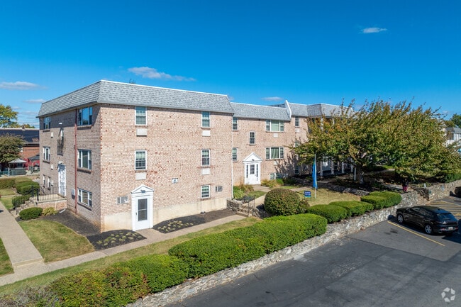
0 Chester Ave
48-00-00772-01
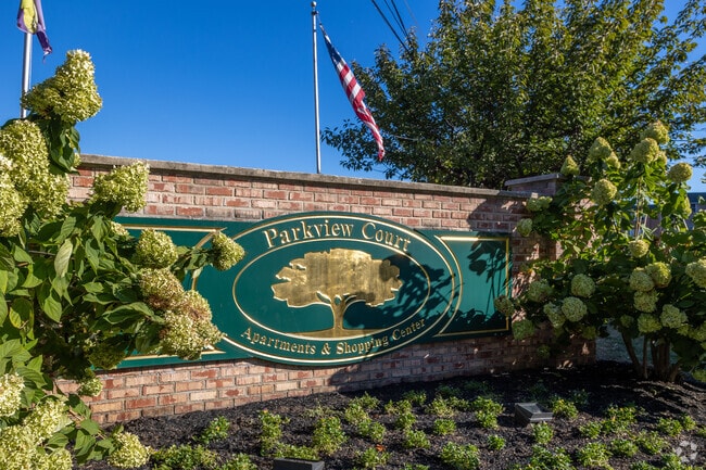
Parkview Court Apts
Apartment
APT COMPLEX SHOP CT 31.641 AC
X
Delaware
42045C0117F
Pennsylvania
2024
31.64 AC
2025
Yeadon
402000
Philadelphia
25,680 SF
Philadelphia-Camden-Wilmington, PA-NJ-DE-MD
DEMOGRAPHICS near 0 Chester Ave
1 Mile
3 Mile
5 Mile
2024 Total Population
34,756
263,886
673,033
2029 Population
34,106
258,183
657,812
Pop Growth 2024-2029
(1.87%)
(2.16%)
(2.26%)
Average Age
37
38
38
2024 Total Households
12,393
101,544
271,818
HH Growth 2024-2029
(1.96%)
(2.29%)
(2.51%)
Median Household Inc
$50,372
$49,434
$58,287
Avg Household Size
2.70
2.50
2.30
2024 Avg HH Vehicles
1.00
1.00
1.00
Median Home Value
$115,655
$149,173
$213,153
Median Year Built
1950
1948
1948
Nearby Places
Map Layers
Map Styles
 Street
 Aerial
- Restaurants
- Banks
- Shops
- Fitness
- Groceries
PUBLIC TRANSPORTATION
COMMUTER RAIL
Darby (R2 - Southeastern Pennsylvania Transportation Authority Regional Rail (SEPTA Regional Rail))
DRIVE
WALK
Distance
Darby (R2 - Southeastern Pennsylvania Transportation Authority Regional Rail (SEPTA Regional Rail))
3 min
14 min
0.7 mi
Lansdowne (R3 - Southeastern Pennsylvania Transportation Authority Regional Rail (SEPTA Regional Rail))
DRIVE
WALK
Distance
Lansdowne (R3 - Southeastern Pennsylvania Transportation Authority Regional Rail (SEPTA Regional Rail))
6 min
1.9 mi
AIRPORT
Philadelphia International
DRIVE
WALK
Distance
Philadelphia International
13 min
5.3 mi
Trenton Mercer
DRIVE
WALK
Distance
Trenton Mercer
65 min
40.7 mi
Freight Ports
Broadway Terminal - Pier 5
DRIVE
WALK
Distance
Broadway Terminal - Pier 5
23 min
11.0 mi
Nearby Properties
Address
Land Use
TOTAL SIZE
Lot Size
Zoning
Address
Land Use
TOTAL SIZE
Lot Size
Zoning
678,227 SF
850.40 AC
SPAIR
Address
Land Use
TOTAL SIZE
Lot Size
Zoning
685,000 SF
47.69 AC
CMX3
Address
Land Use
TOTAL SIZE
Lot Size
Zoning
387,472 SF
4.61 AC
I3
Address
Land Use
TOTAL SIZE
Lot Size
Zoning
158,496 SF
Address
Land Use
TOTAL SIZE
Lot Size
Zoning
910,000 SF
70 AC
I2
Address
Land Use
TOTAL SIZE
Lot Size
Zoning
175,069 SF
2.20 AC
CMX3
Address
Land Use
TOTAL SIZE
Lot Size
Zoning
10,080 SF
3.10 AC
I3
Address
Land Use
TOTAL SIZE
Lot Size
Zoning
488,254 SF
31.56 AC
I2
Address
Land Use
TOTAL SIZE
Lot Size
Zoning
97,810 SF
40 AC
I3
Address
Land Use
TOTAL SIZE
Lot Size
Zoning
448,864 SF
32.89 AC
Address
Land Use
TOTAL SIZE
Lot Size
Zoning
323,248 SF
2.90 AC
SPAIR
Address
Land Use
TOTAL SIZE
Lot Size
Zoning
95,895 SF
2.94 AC
RTA1
Address
Land Use
TOTAL SIZE
Lot Size
Zoning
180,000 SF
0.57 AC
RM4
Address
Land Use
TOTAL SIZE
Lot Size
Zoning
128,464 SF
1.03 AC
RM1
Address
Land Use
TOTAL SIZE
Lot Size
Zoning
200,000 SF
22 AC
RMX3
Address
Land Use
TOTAL SIZE
Lot Size
Zoning
164,640 SF
0.62 AC
CMX4
Address
Land Use
TOTAL SIZE
Lot Size
Zoning
226,764 SF
5.72 AC
CMX3
Address
Land Use
TOTAL SIZE
Lot Size
Zoning
140,010 SF
28.50 AC
ICMX
Address
Land Use
TOTAL SIZE
Lot Size
Zoning
63.81 AC
I2
Address
Land Use
TOTAL SIZE
Lot Size
Zoning
6,040 SF
16.45 AC
Address
Land Use
TOTAL SIZE
Lot Size
Zoning
63.53 AC
CMX3
Address
Land Use
TOTAL SIZE
Lot Size
Zoning
120,349 SF
37.24 AC
I3
Address
Land Use
TOTAL SIZE
Lot Size
Zoning
136,972 SF
27 AC
Address
Land Use
TOTAL SIZE
Lot Size
Zoning
33,200 SF
19.55 AC
I2
Address
Land Use
TOTAL SIZE
Lot Size
Zoning
3,600 SF
6.61 AC
SPPOA
Address
Land Use
TOTAL SIZE
Lot Size
Zoning
454,536 SF
26.63 AC
Address
Land Use
TOTAL SIZE
Lot Size
Zoning
164,184 SF
14.62 AC
I2
Address
Land Use
TOTAL SIZE
Lot Size
Zoning
96,500 SF
6.11 AC
CMX3
Address
Land Use
TOTAL SIZE
Lot Size
Zoning
363,215 SF
7.27 AC
RM1
The World's #1 Commercial Real Estate Marketplace
Connect with us
© 2025 CoStar Group
The information above has been obtained from sources believed reliable. While we do not doubt its accuracy we have not verified it and make no guarantee, warranty or representation about it. It is your responsibility to independently confirm its accuracy and completeness. Any projections, opinions, assumptions, or estimates used are for example only and do not represent the current or future performance of the property. The value of this transaction to you depends on tax and other factors which should be evaluated by your tax, financial, and legal advisors. You and your advisors should conduct a careful, independent investigation of the property to determine to your satisfaction the suitability of the property for your needs.