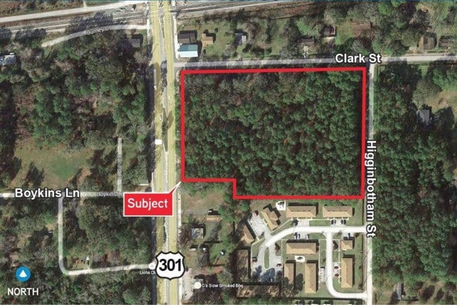
Property Record
0 Clark St, Baldwin, FL 32234

Save to a Folder
{{folder.Name}}
{{folder.ListingIds.length}} Properties
{{folder.ListingIds.length}} Property
Create a New Folder
Property Detail
0 Clark St
000531-0000
26-2S-23E 6.79 SW1/4 OF NW1/4 PT RECD O/R 21737-279
Commercialacreage
DUVAL
BRMD
Florida
B and X Area of moderate flood hazard, usually the area between the limits of the 100-year and 500-year floods.
6.71 AC
2025
Northwest Jacksonville
2026
Jacksonville (Florida)
017300
Jacksonville, FL
NEARBY LISTINGS FOR SALE OR LEASE
DEMOGRAPHICS near 0 Clark St
1 mile
3 mile
5 mile
2025 Total Population
1,930
2,565
3,252
2030 Population
2,091
2,784
3,532
Pop Growth 2025-2030
+ 8.34%
+ 8.54%
+ 8.61%
Average Age
41
41
42
2025 Total Households
788
1,045
1,309
HH Growth 2025-2030
+ 8.63%
+ 8.90%
+ 8.94%
Median Household Inc
$59,385
$55,394
$55,346
Avg Household Size
2.50
2.50
2.50
2025 Avg HH Vehicles
2.00
2.00
2.00
Median Home Value
$195,262
$208,750
$211,364
Median Year Built
1980
1982
1986
Nearby Places
Map Layers
Map Styles
 Street
 Aerial
Layers
 Traffic
 Biking
Places
Listings with unknown addresses are not visible on the map
- Restaurants
- Banks
- Shops
- Fitness
- Groceries
PUBLIC TRANSPORTATION
AIRPORT
Jacksonville International
Drive
Walk
Distance
Jacksonville International
42 min
31.1 mi
Freight Ports
Jacksonville Port
Drive
Walk
Distance
Jacksonville Port
34 min
24.9 mi
SALE & LEASE HISTORY
LISTING DATE
SALE/LEASE

Sep 24, 2016
For Sale
Sep 01, 2017
For Sale
May 07, 2020
For Sale
Nearby Properties
Address
Land Use
TOTAL SIZE
Lot Size
Zoning
Address
Land Use
TOTAL SIZE
Lot Size
Zoning
1,285,084 SF
200.84 AC
IL
Address
Land Use
TOTAL SIZE
Lot Size
Zoning
438,134 SF
121.01 AC
IH
Address
Land Use
TOTAL SIZE
Lot Size
Zoning
40,786 SF
17.10 AC
PUD
Address
Land Use
TOTAL SIZE
Lot Size
Zoning
60,080 SF
8.57 AC
BI
Address
Land Use
TOTAL SIZE
Lot Size
Zoning
37,514 SF
444.53 AC
AGR
Address
Land Use
TOTAL SIZE
Lot Size
Zoning
28,529 SF
16.76 AC
CCG-2
Address
Land Use
TOTAL SIZE
Lot Size
Zoning
768 SF
441.67 AC
AGR
Address
Land Use
TOTAL SIZE
Lot Size
Zoning
55,070 SF
12.01 AC
BGI
Address
Land Use
TOTAL SIZE
Lot Size
Zoning
3,379 SF
1.39 AC
IH
Address
Land Use
TOTAL SIZE
Lot Size
Zoning
17.21 AC
BI
Address
Land Use
TOTAL SIZE
Lot Size
Zoning
94,005 SF
21.45 AC
BGI
Address
Land Use
TOTAL SIZE
Lot Size
Zoning
20.92 AC
IL
Address
Land Use
TOTAL SIZE
Lot Size
Zoning
15,703 SF
4.55 AC
CCG-2
Address
Land Use
TOTAL SIZE
Lot Size
Zoning
4,094 SF
5.49 AC
CCG-1
Address
Land Use
TOTAL SIZE
Lot Size
Zoning
21,192 SF
2.15 AC
CCG-1
Address
Land Use
TOTAL SIZE
Lot Size
Zoning
23,547 SF
2.49 AC
BRLD
Address
Land Use
TOTAL SIZE
Lot Size
Zoning
44.94 AC
IL
Address
Land Use
TOTAL SIZE
Lot Size
Zoning
253.40 AC
AGR
Address
Land Use
TOTAL SIZE
Lot Size
Zoning
644.15 AC
AGR
Address
Land Use
TOTAL SIZE
Lot Size
Zoning
24,010 SF
4.22 AC
BLI
Address
Land Use
TOTAL SIZE
Lot Size
Zoning
43,848 SF
7 AC
BRMD
Address
Land Use
TOTAL SIZE
Lot Size
Zoning
10,658 SF
1.76 AC
BC
Address
Land Use
TOTAL SIZE
Lot Size
Zoning
6,180 SF
0.67 AC
BC
Address
Land Use
TOTAL SIZE
Lot Size
Zoning
441 SF
5.05 AC
BI
Address
Land Use
TOTAL SIZE
Lot Size
Zoning
5,132 SF
53.33 AC
IH
Address
Land Use
TOTAL SIZE
Lot Size
Zoning
7,008 SF
0.78 AC
BC
Address
Land Use
TOTAL SIZE
Lot Size
Zoning
61.76 AC
AGR
Address
Land Use
TOTAL SIZE
Lot Size
Zoning
8,144 SF
1.35 AC
BCIT
Address
Land Use
TOTAL SIZE
Lot Size
Zoning
14,192 SF
4.58 AC
CCG-2
Address
Land Use
TOTAL SIZE
Lot Size
Zoning
10,562 SF
45.02 AC
IH
The World's #1 Commercial Real Estate Marketplace
Connect with us
© 2026 CoStar Group
The information above has been obtained from sources believed reliable. While we do not doubt its accuracy we have not verified it and make no guarantee, warranty or representation about it. It is your responsibility to independently confirm its accuracy and completeness. Any projections, opinions, assumptions, or estimates used are for example only and do not represent the current or future performance of the property. The value of this transaction to you depends on tax and other factors which should be evaluated by your tax, financial, and legal advisors. You and your advisors should conduct a careful, independent investigation of the property to determine to your satisfaction the suitability of the property for your needs.