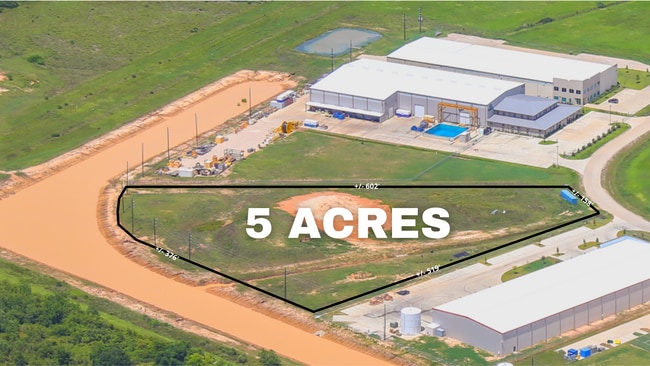
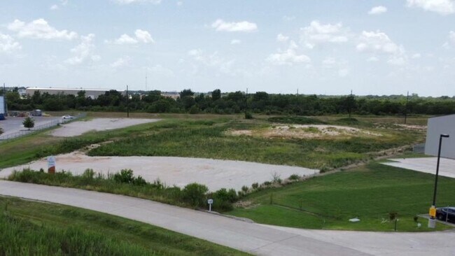
Property Record
0 Clay Rd, Katy, TX 77493


Property Detail
0 Clay Rd
Houston-Pasadena-The Woodlands, TX
RES A6 BLK 1 ENERGY PARK WEST SEC 1
1358020010009
HARRIS
Commercialnec
Texas
B and X Area of moderate flood hazard, usually the area between the limits of the 100-year and 500-year floods.
5 AC
2024
Katy/Grand Parkway West
2025
Houston
542800
NEARBY LISTINGS FOR SALE OR LEASE
DEMOGRAPHICS near 0 Clay Rd
1 mile
3 mile
5 mile
2025 Total Population
4,779
64,039
143,016
2030 Population
5,435
71,904
158,632
Pop Growth 2025-2030
+ 13.73%
+ 12.28%
+ 10.92%
Average Age
33
35
35
2025 Total Households
1,437
19,818
46,422
HH Growth 2025-2030
+ 13.78%
+ 12.36%
+ 11.03%
Median Household Inc
$138,601
$116,025
$104,757
Avg Household Size
3.30
3.20
3.00
2025 Avg HH Vehicles
2.00
2.00
2.00
Median Home Value
$372,424
$358,172
$330,754
Median Year Built
2011
2011
2010
Nearby Places
Map Layers
Map Styles
 Street
 Aerial
Layers
 Traffic
 Biking
Places
Listings with unknown addresses are not visible on the map
- Restaurants
- Banks
- Shops
- Fitness
- Groceries
SALE & LEASE HISTORY
LISTING DATE
SALE/LEASE

Oct 21, 2021
For Lease
Feb 13, 2024
For Lease
Nearby Properties
Address
Land Use
TOTAL SIZE
Lot Size
Zoning
Address
Land Use
TOTAL SIZE
Lot Size
Zoning
807,360 SF
54.15 AC
Address
Land Use
TOTAL SIZE
Lot Size
Zoning
339,835 SF
12.09 AC
Address
Land Use
TOTAL SIZE
Lot Size
Zoning
290,973 SF
15 AC
Address
Land Use
TOTAL SIZE
Lot Size
Zoning
395,495 SF
13.83 AC
Address
Land Use
TOTAL SIZE
Lot Size
Zoning
270,728 SF
9.45 AC
Address
Land Use
TOTAL SIZE
Lot Size
Zoning
292,645 SF
12.71 AC
Address
Land Use
TOTAL SIZE
Lot Size
Zoning
439,808 SF
23.75 AC
Address
Land Use
TOTAL SIZE
Lot Size
Zoning
321,565 SF
11.47 AC
Address
Land Use
TOTAL SIZE
Lot Size
Zoning
385,744 SF
25.88 AC
Address
Land Use
TOTAL SIZE
Lot Size
Zoning
195,501 SF
7.79 AC
Address
Land Use
TOTAL SIZE
Lot Size
Zoning
226,076 SF
10.37 AC
Address
Land Use
TOTAL SIZE
Lot Size
Zoning
123,466 SF
11.37 AC
Address
Land Use
TOTAL SIZE
Lot Size
Zoning
193,230 SF
16.92 AC
Address
Land Use
TOTAL SIZE
Lot Size
Zoning
62.55 AC
Address
Land Use
TOTAL SIZE
Lot Size
Zoning
78.32 AC
Address
Land Use
TOTAL SIZE
Lot Size
Zoning
119,086 SF
18.61 AC
Address
Land Use
TOTAL SIZE
Lot Size
Zoning
131,811 SF
29.47 AC
Address
Land Use
TOTAL SIZE
Lot Size
Zoning
161,052 SF
2.73 AC
Address
Land Use
TOTAL SIZE
Lot Size
Zoning
134,892 SF
5.62 AC
Address
Land Use
TOTAL SIZE
Lot Size
Zoning
97,985 SF
14.20 AC
Address
Land Use
TOTAL SIZE
Lot Size
Zoning
97,650 SF
7.79 AC
Address
Land Use
TOTAL SIZE
Lot Size
Zoning
63,787 SF
4.63 AC
Address
Land Use
TOTAL SIZE
Lot Size
Zoning
86,378 SF
5.50 AC
Address
Land Use
TOTAL SIZE
Lot Size
Zoning
40,200 SF
2.95 AC
Address
Land Use
TOTAL SIZE
Lot Size
Zoning
167,944 SF
12 AC
Address
Land Use
TOTAL SIZE
Lot Size
Zoning
13,178 SF
3.10 AC
Address
Land Use
TOTAL SIZE
Lot Size
Zoning
41.98 AC
Address
Land Use
TOTAL SIZE
Lot Size
Zoning
35,875 SF
5.35 AC
Address
Land Use
TOTAL SIZE
Lot Size
Zoning
111.36 AC
Address
Land Use
TOTAL SIZE
Lot Size
Zoning
24.52 AC
The World's #1 Commercial Real Estate Marketplace
Connect with us
© 2026 CoStar Group
The information above has been obtained from sources believed reliable. While we do not doubt its accuracy we have not verified it and make no guarantee, warranty or representation about it. It is your responsibility to independently confirm its accuracy and completeness. Any projections, opinions, assumptions, or estimates used are for example only and do not represent the current or future performance of the property. The value of this transaction to you depends on tax and other factors which should be evaluated by your tax, financial, and legal advisors. You and your advisors should conduct a careful, independent investigation of the property to determine to your satisfaction the suitability of the property for your needs.