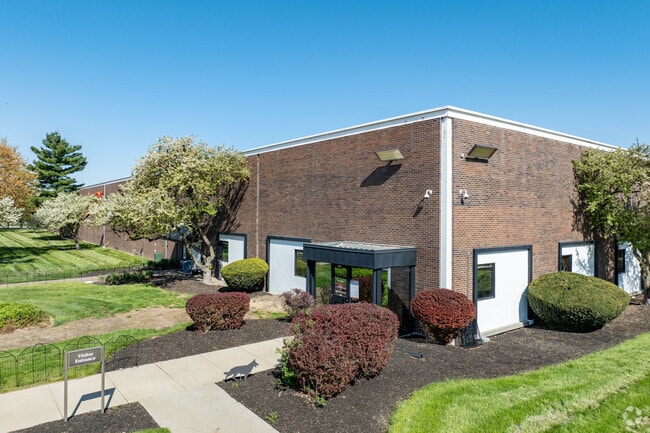
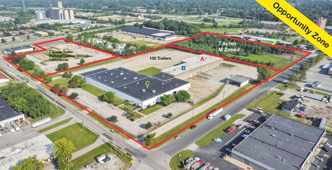
Property Record
4500 Groves Rd, Columbus, OH 43232

Current Lease Availabilities
Property Detail
4500 Groves Rd
010-038040
21.006 ACRES
Lightindustrial
Franklin
B and X Area of moderate flood hazard, usually the area between the limits of the 100-year and 500-year floods.
Ohio
2024
20.52 AC
2025
I-70 East Corridor
009325
Columbus
120,116 SF
Columbus, OH
NEARBY LISTINGS FOR SALE OR LEASE
DEMOGRAPHICS near 4500 Groves Rd
1 mile
3 mile
5 mile
2025 Total Population
12,516
114,529
247,342
2030 Population
12,852
117,902
255,728
Pop Growth 2025-2030
+ 2.68%
+ 2.95%
+ 3.39%
Average Age
37
38
38
2025 Total Households
5,307
47,188
101,149
HH Growth 2025-2030
+ 3.05%
+ 3.12%
+ 3.56%
Median Household Inc
$42,064
$51,756
$57,254
Avg Household Size
2.30
2.40
2.40
2025 Avg HH Vehicles
1.00
2.00
2.00
Median Home Value
$154,765
$174,227
$226,630
Median Year Built
1969
1970
1973
Nearby Places
Map Layers
Map Styles
 Street
 Aerial
Layers
 Traffic
 Biking
Places
Listings with unknown addresses are not visible on the map
- Restaurants
- Banks
- Shops
- Fitness
- Groceries
PUBLIC TRANSPORTATION
AIRPORT
John Glenn Columbus International
Drive
Walk
Distance
John Glenn Columbus International
15 min
8.6 mi
Rickenbacker International
Drive
Walk
Distance
Rickenbacker International
17 min
9.7 mi
Freight Ports
Port of Toledo
Drive
Walk
Distance
Port of Toledo
194 min
157.0 mi
Nearby Properties
Address
Land Use
TOTAL SIZE
Lot Size
Zoning
Address
Land Use
TOTAL SIZE
Lot Size
Zoning
180,383 SF
15.54 AC
Address
Land Use
TOTAL SIZE
Lot Size
Zoning
230,994 SF
23.82 AC
Address
Land Use
TOTAL SIZE
Lot Size
Zoning
181,204 SF
22.90 AC
Address
Land Use
TOTAL SIZE
Lot Size
Zoning
68,492 SF
23.63 AC
Address
Land Use
TOTAL SIZE
Lot Size
Zoning
66,177 SF
11.17 AC
Address
Land Use
TOTAL SIZE
Lot Size
Zoning
217,088 SF
10.67 AC
Address
Land Use
TOTAL SIZE
Lot Size
Zoning
125,219 SF
3.49 AC
Address
Land Use
TOTAL SIZE
Lot Size
Zoning
2,117,753 SF
117.95 AC
Address
Land Use
TOTAL SIZE
Lot Size
Zoning
188,305 SF
27.46 AC
Address
Land Use
TOTAL SIZE
Lot Size
Zoning
497,642 SF
29.98 AC
Address
Land Use
TOTAL SIZE
Lot Size
Zoning
158,325 SF
34.39 AC
Address
Land Use
TOTAL SIZE
Lot Size
Zoning
69,070 SF
20.06 AC
Address
Land Use
TOTAL SIZE
Lot Size
Zoning
159,719 SF
36.24 AC
Address
Land Use
TOTAL SIZE
Lot Size
Zoning
79,472 SF
8.45 AC
Address
Land Use
TOTAL SIZE
Lot Size
Zoning
175,313 SF
27.10 AC
Address
Land Use
TOTAL SIZE
Lot Size
Zoning
115,095 SF
14.02 AC
Address
Land Use
TOTAL SIZE
Lot Size
Zoning
58,272 SF
7.86 AC
Address
Land Use
TOTAL SIZE
Lot Size
Zoning
57,613 SF
10.08 AC
Address
Land Use
TOTAL SIZE
Lot Size
Zoning
47,064 SF
32.95 AC
Address
Land Use
TOTAL SIZE
Lot Size
Zoning
32,864 SF
2.82 AC
Address
Land Use
TOTAL SIZE
Lot Size
Zoning
96,372 SF
44.58 AC
Address
Land Use
TOTAL SIZE
Lot Size
Zoning
70,192 SF
20.22 AC
Address
Land Use
TOTAL SIZE
Lot Size
Zoning
52,181 SF
26.64 AC
Address
Land Use
TOTAL SIZE
Lot Size
Zoning
172,822 SF
48.21 AC
Address
Land Use
TOTAL SIZE
Lot Size
Zoning
144,161 SF
16.50 AC
Address
Land Use
TOTAL SIZE
Lot Size
Zoning
96,720 SF
5.96 AC
Address
Land Use
TOTAL SIZE
Lot Size
Zoning
132,498 SF
19.50 AC
Address
Land Use
TOTAL SIZE
Lot Size
Zoning
71,531 SF
28.15 AC
Address
Land Use
TOTAL SIZE
Lot Size
Zoning
147,416 SF
20.73 AC
Address
Land Use
TOTAL SIZE
Lot Size
Zoning
77,183 SF
38.61 AC
The World's #1 Commercial Real Estate Marketplace
Connect with us
© 2026 CoStar Group
The information above has been obtained from sources believed reliable. While we do not doubt its accuracy we have not verified it and make no guarantee, warranty or representation about it. It is your responsibility to independently confirm its accuracy and completeness. Any projections, opinions, assumptions, or estimates used are for example only and do not represent the current or future performance of the property. The value of this transaction to you depends on tax and other factors which should be evaluated by your tax, financial, and legal advisors. You and your advisors should conduct a careful, independent investigation of the property to determine to your satisfaction the suitability of the property for your needs.