Property Record
0 Cols Lancaster Rd, Madison, OH 44057

Property Detail
0 Cols Lancaster Rd
Columbus, OH
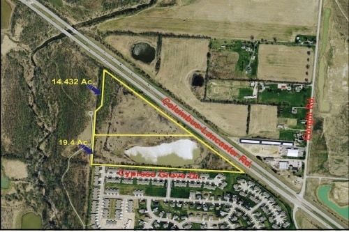
NW QR DOWER R21 T11 S15 19.400 ACRES
180-003045
FRANKLIN
Commercialacreage
Ohio
AE The base floodplain where base flood elevations are provided. AE Zones are now used on new format FIRMs instead of A1-A30 Zones.
19.40 AC
2024
Southeast
2025
Columbus
205701
NEARBY LISTINGS FOR SALE OR LEASE
DEMOGRAPHICS near 0 Cols Lancaster Rd
1 mile
3 mile
5 mile
2025 Total Population
2,819
49,571
156,707
2030 Population
2,910
51,238
161,778
Pop Growth 2025-2030
+ 3.23%
+ 3.36%
+ 3.24%
Average Age
47
38
37
2025 Total Households
1,355
19,939
61,850
HH Growth 2025-2030
+ 3.32%
+ 3.51%
+ 3.37%
Median Household Inc
$71,193
$65,798
$60,626
Avg Household Size
2.10
2.40
2.50
2025 Avg HH Vehicles
2.00
2.00
2.00
Median Home Value
$278,275
$219,773
$223,235
Median Year Built
1994
1990
1982
Nearby Places
Map Layers
Map Styles
 Street
 Aerial
Layers
 Traffic
 Biking
Places
Listings with unknown addresses are not visible on the map
- Restaurants
- Banks
- Shops
- Fitness
- Groceries
PUBLIC TRANSPORTATION
AIRPORT
Rickenbacker International
Drive
Walk
Distance
Rickenbacker International
18 min
7.5 mi
John Glenn Columbus International
Drive
Walk
Distance
John Glenn Columbus International
25 min
14.7 mi
Freight Ports
Port of Toledo
Drive
Walk
Distance
Port of Toledo
204 min
162.9 mi
Nearby Properties
Address
Land Use
TOTAL SIZE
Lot Size
Zoning
Address
Land Use
TOTAL SIZE
Lot Size
Zoning
471,215 SF
49.74 AC
Address
Land Use
TOTAL SIZE
Lot Size
Zoning
553,548 SF
46.23 AC
Address
Land Use
TOTAL SIZE
Lot Size
Zoning
230,994 SF
23.82 AC
Address
Land Use
TOTAL SIZE
Lot Size
Zoning
307,190 SF
55.18 AC
Address
Land Use
TOTAL SIZE
Lot Size
Zoning
181,204 SF
22.90 AC
Address
Land Use
TOTAL SIZE
Lot Size
Zoning
68,492 SF
23.63 AC
Address
Land Use
TOTAL SIZE
Lot Size
Zoning
250,174 SF
178.12 AC
Address
Land Use
TOTAL SIZE
Lot Size
Zoning
528,750 SF
42.14 AC
Address
Land Use
TOTAL SIZE
Lot Size
Zoning
478,544 SF
23.04 AC
Address
Land Use
TOTAL SIZE
Lot Size
Zoning
446,160 SF
91.12 AC
Address
Land Use
TOTAL SIZE
Lot Size
Zoning
46,340 SF
10.58 AC
Address
Land Use
TOTAL SIZE
Lot Size
Zoning
446,160 SF
22.71 AC
Address
Land Use
TOTAL SIZE
Lot Size
Zoning
122,938 SF
29.37 AC
Address
Land Use
TOTAL SIZE
Lot Size
Zoning
263,120 SF
23.12 AC
Address
Land Use
TOTAL SIZE
Lot Size
Zoning
69,070 SF
20.06 AC
Address
Land Use
TOTAL SIZE
Lot Size
Zoning
312,080 SF
24.05 AC
Address
Land Use
TOTAL SIZE
Lot Size
Zoning
29,311 SF
24.95 AC
Address
Land Use
TOTAL SIZE
Lot Size
Zoning
159,719 SF
36.24 AC
Address
Land Use
TOTAL SIZE
Lot Size
Zoning
350,946 SF
22.60 AC
Address
Land Use
TOTAL SIZE
Lot Size
Zoning
324,000 SF
20.91 AC
Address
Land Use
TOTAL SIZE
Lot Size
Zoning
115,095 SF
14.02 AC
Address
Land Use
TOTAL SIZE
Lot Size
Zoning
259,616 SF
23.54 AC
Address
Land Use
TOTAL SIZE
Lot Size
Zoning
22,368 SF
23.08 AC
Address
Land Use
TOTAL SIZE
Lot Size
Zoning
319,720 SF
14.85 AC
Address
Land Use
TOTAL SIZE
Lot Size
Zoning
101,189 SF
22.58 AC
Address
Land Use
TOTAL SIZE
Lot Size
Zoning
241,040 SF
16.44 AC
Address
Land Use
TOTAL SIZE
Lot Size
Zoning
248,400 SF
15.53 AC
Address
Land Use
TOTAL SIZE
Lot Size
Zoning
569,216 SF
42.86 AC
Address
Land Use
TOTAL SIZE
Lot Size
Zoning
149,413 SF
22.43 AC
Address
Land Use
TOTAL SIZE
Lot Size
Zoning
142,054 SF
20.32 AC
The World's #1 Commercial Real Estate Marketplace
Connect with us
© 2026 CoStar Group
The information above has been obtained from sources believed reliable. While we do not doubt its accuracy we have not verified it and make no guarantee, warranty or representation about it. It is your responsibility to independently confirm its accuracy and completeness. Any projections, opinions, assumptions, or estimates used are for example only and do not represent the current or future performance of the property. The value of this transaction to you depends on tax and other factors which should be evaluated by your tax, financial, and legal advisors. You and your advisors should conduct a careful, independent investigation of the property to determine to your satisfaction the suitability of the property for your needs.