Property Record
Cornog Rd, Lavonia, GA 30553
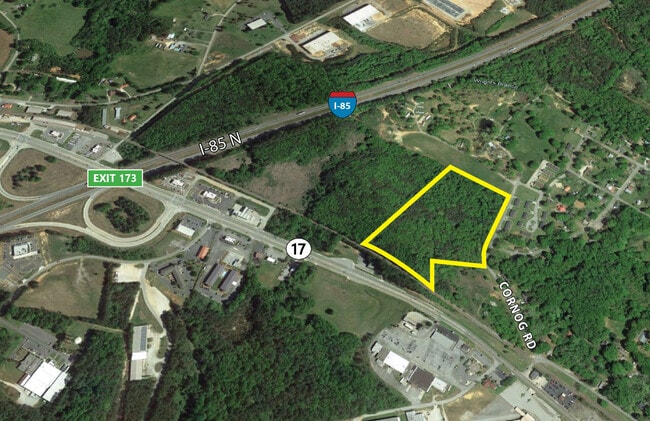
This Property Is For Sale
NEARBY LISTINGS FOR SALE OR LEASE
Property Detail
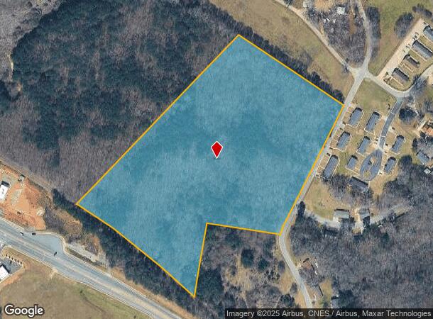
Cornog Rd
063-120
13.60 AC
Commercialacreage
Franklin
X
Georgia
13147C0025D
13.60 AC
2025
Georgia Northeast
2025
Other Market Areas
890101
DEMOGRAPHICS near Cornog Rd
1 Mile
3 Mile
5 Mile
2024 Total Population
1,378
4,639
10,066
2029 Population
1,470
4,947
10,859
Pop Growth 2024-2029
+ 6.68%
+ 6.64%
+ 7.88%
Average Age
39
40
42
2024 Total Households
544
1,797
3,998
HH Growth 2024-2029
+ 6.43%
+ 6.34%
+ 7.73%
Median Household Inc
$34,401
$50,223
$56,303
Avg Household Size
2.50
2.50
2.50
2024 Avg HH Vehicles
2.00
2.00
2.00
Median Home Value
$170,154
$154,133
$163,219
Median Year Built
1978
1986
1989
Nearby Places
Map Layers
Map Styles
 Street
 Aerial
- Restaurants
- Banks
- Shops
- Fitness
- Groceries
Nearby Properties
Address
Land Use
TOTAL SIZE
Lot Size
Zoning
Address
Land Use
TOTAL SIZE
Lot Size
Zoning
69,598 SF
39.21 AC
Address
Land Use
TOTAL SIZE
Lot Size
Zoning
3,987 SF
19.93 AC
UNZONED RU
Address
Land Use
TOTAL SIZE
Lot Size
Zoning
425,670 SF
78 AC
UNZONED RU
Address
Land Use
TOTAL SIZE
Lot Size
Zoning
100,000 SF
7.59 AC
UNZONED RU
Address
Land Use
TOTAL SIZE
Lot Size
Zoning
535,990 SF
55.95 AC
INDUSTRIAL
Address
Land Use
TOTAL SIZE
Lot Size
Zoning
57,360 SF
2 AC
COMMERCIAL
Address
Land Use
TOTAL SIZE
Lot Size
Zoning
40,592 SF
Address
Land Use
TOTAL SIZE
Lot Size
Zoning
5,463 SF
29.50 AC
UNZONED RU
Address
Land Use
TOTAL SIZE
Lot Size
Zoning
129,600 SF
20.18 AC
INDUSTRIAL
Address
Land Use
TOTAL SIZE
Lot Size
Zoning
69,410 SF
22 AC
UNZONED RU
Address
Land Use
TOTAL SIZE
Lot Size
Zoning
3,080 SF
7.72 AC
UNZONED RU
Address
Land Use
TOTAL SIZE
Lot Size
Zoning
13,368 SF
31.20 AC
INDUSTRIAL
Address
Land Use
TOTAL SIZE
Lot Size
Zoning
17,850 SF
4.98 AC
UNZONED RU
Address
Land Use
TOTAL SIZE
Lot Size
Zoning
110,000 SF
24.13 AC
UNZONED RU
Address
Land Use
TOTAL SIZE
Lot Size
Zoning
46,960 SF
1.64 AC
Address
Land Use
TOTAL SIZE
Lot Size
Zoning
82,125 SF
10 AC
COMMERCIAL
Address
Land Use
TOTAL SIZE
Lot Size
Zoning
52,440 SF
7.49 AC
UNZONED RU
Address
Land Use
TOTAL SIZE
Lot Size
Zoning
71,560 SF
30.15 AC
COMMERCIAL
Address
Land Use
TOTAL SIZE
Lot Size
Zoning
27,768 SF
6.63 AC
UNZONED RU
Address
Land Use
TOTAL SIZE
Lot Size
Zoning
45,000 SF
19.24 AC
UNZONED UR
Address
Land Use
TOTAL SIZE
Lot Size
Zoning
35,250 SF
19.92 AC
COMMERCIAL
Address
Land Use
TOTAL SIZE
Lot Size
Zoning
42,360 SF
13.92 AC
COMMERCIAL
Address
Land Use
TOTAL SIZE
Lot Size
Zoning
15.29 AC
Address
Land Use
TOTAL SIZE
Lot Size
Zoning
301.66 AC
INDUSTRIAL
Address
Land Use
TOTAL SIZE
Lot Size
Zoning
57,497 SF
7.93 AC
UNZONED RU
Address
Land Use
TOTAL SIZE
Lot Size
Zoning
52,440 SF
5.77 AC
INDUSTRIAL
Address
Land Use
TOTAL SIZE
Lot Size
Zoning
18,208 SF
2.77 AC
COMMERCIAL
Address
Land Use
TOTAL SIZE
Lot Size
Zoning
28,620 SF
4.37 AC
COMMERCIAL
Address
Land Use
TOTAL SIZE
Lot Size
Zoning
19,792 SF
12.45 AC
UNZONED RU
Address
Land Use
TOTAL SIZE
Lot Size
Zoning
6,092 SF
2.52 AC
COMMERCIAL
The World's #1 Commercial Real Estate Marketplace
Connect with us
© 2026 CoStar Group
The information above has been obtained from sources believed reliable. While we do not doubt its accuracy we have not verified it and make no guarantee, warranty or representation about it. It is your responsibility to independently confirm its accuracy and completeness. Any projections, opinions, assumptions, or estimates used are for example only and do not represent the current or future performance of the property. The value of this transaction to you depends on tax and other factors which should be evaluated by your tax, financial, and legal advisors. You and your advisors should conduct a careful, independent investigation of the property to determine to your satisfaction the suitability of the property for your needs.