Property Record
0 County Rd 48 Rd, Robertsdale, AL 36567
NEARBY LISTINGS FOR SALE OR LEASE
-
-
View all Robertsdale listings for sale on LoopNet.com
Property Detail
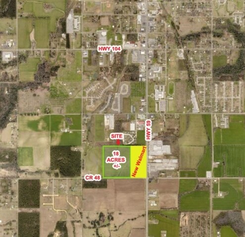
0 County Rd 48 Rd
Daphne-Fairhope-Foley, AL
Carpenter Vaughn Overstreet Property Sub
48-03-07-0-000-014.003
18 AC TRACT 3 CARPENTER, VAUGHN, OVERSTREET PROPERTY SUB SLIDE 2494-C
Farms
Baldwin
X
Alabama
01003C0687M
18 AC
2024
Baldwin County
2024
Mobile
010904
DEMOGRAPHICS near 0 County Rd 48 Rd
1 Mile
3 Mile
5 Mile
2024 Total Population
1,501
9,527
18,874
2029 Population
1,674
10,768
21,441
Pop Growth 2024-2029
+ 11.53%
+ 13.03%
+ 13.60%
Average Age
36
38
38
2024 Total Households
554
3,466
6,818
HH Growth 2024-2029
+ 10.83%
+ 12.49%
+ 13.13%
Median Household Inc
$61,470
$58,208
$59,406
Avg Household Size
2.70
2.70
2.60
2024 Avg HH Vehicles
2.00
2.00
2.00
Median Home Value
$230,081
$187,263
$197,135
Median Year Built
1997
1996
1996
Nearby Places
Map Layers
Map Styles
 Street
 Aerial
- Restaurants
- Banks
- Shops
- Fitness
- Groceries
PUBLIC TRANSPORTATION
AIRPORT
Pensacola International
DRIVE
WALK
Distance
Pensacola International
50 min
32.9 mi
Mobile International
DRIVE
WALK
Distance
Mobile International
43 min
33.8 mi
Freight Ports
Port of Mobile
DRIVE
WALK
Distance
Port of Mobile
38 min
30.4 mi
SALE & LEASE HISTORY
LISTING DATE
SALE/LEASE

Sep 24, 2016
For Sale
Nearby Properties
Address
Land Use
TOTAL SIZE
Lot Size
Zoning
Address
Land Use
TOTAL SIZE
Lot Size
Zoning
8,922 SF
3.72 AC
Address
Land Use
TOTAL SIZE
Lot Size
Zoning
30,104 SF
9.30 AC
Address
Land Use
TOTAL SIZE
Lot Size
Zoning
5,210 SF
6.80 AC
Address
Land Use
TOTAL SIZE
Lot Size
Zoning
5,182 SF
2 AC
Address
Land Use
TOTAL SIZE
Lot Size
Zoning
17,704 SF
90 AC
Address
Land Use
TOTAL SIZE
Lot Size
Zoning
3,710 SF
6.80 AC
Address
Land Use
TOTAL SIZE
Lot Size
Zoning
Address
Land Use
TOTAL SIZE
Lot Size
Zoning
12,650 SF
1.60 AC
Address
Land Use
TOTAL SIZE
Lot Size
Zoning
3,383 SF
3.21 AC
Address
Land Use
TOTAL SIZE
Lot Size
Zoning
9,055 SF
0.87 AC
Address
Land Use
TOTAL SIZE
Lot Size
Zoning
Address
Land Use
TOTAL SIZE
Lot Size
Zoning
6,100 SF
1.70 AC
Address
Land Use
TOTAL SIZE
Lot Size
Zoning
2,400 SF
1.58 AC
Address
Land Use
TOTAL SIZE
Lot Size
Zoning
5,500 SF
123 AC
Address
Land Use
TOTAL SIZE
Lot Size
Zoning
4,580 SF
4.62 AC
Address
Land Use
TOTAL SIZE
Lot Size
Zoning
11,340 SF
21 AC
Address
Land Use
TOTAL SIZE
Lot Size
Zoning
3,600 SF
33 AC
Address
Land Use
TOTAL SIZE
Lot Size
Zoning
Address
Land Use
TOTAL SIZE
Lot Size
Zoning
220 SF
25 AC
Address
Land Use
TOTAL SIZE
Lot Size
Zoning
Address
Land Use
TOTAL SIZE
Lot Size
Zoning
Address
Land Use
TOTAL SIZE
Lot Size
Zoning
Address
Land Use
TOTAL SIZE
Lot Size
Zoning
Address
Land Use
TOTAL SIZE
Lot Size
Zoning
Address
Land Use
TOTAL SIZE
Lot Size
Zoning
Address
Land Use
TOTAL SIZE
Lot Size
Zoning
Address
Land Use
TOTAL SIZE
Lot Size
Zoning
672 SF
29 AC
Address
Land Use
TOTAL SIZE
Lot Size
Zoning
Address
Land Use
TOTAL SIZE
Lot Size
Zoning
Address
Land Use
TOTAL SIZE
Lot Size
Zoning
1,200 SF
3 AC
The World's #1 Commercial Real Estate Marketplace
Connect with us
© 2025 CoStar Group
The information above has been obtained from sources believed reliable. While we do not doubt its accuracy we have not verified it and make no guarantee, warranty or representation about it. It is your responsibility to independently confirm its accuracy and completeness. Any projections, opinions, assumptions, or estimates used are for example only and do not represent the current or future performance of the property. The value of this transaction to you depends on tax and other factors which should be evaluated by your tax, financial, and legal advisors. You and your advisors should conduct a careful, independent investigation of the property to determine to your satisfaction the suitability of the property for your needs.