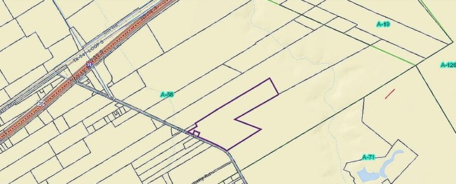
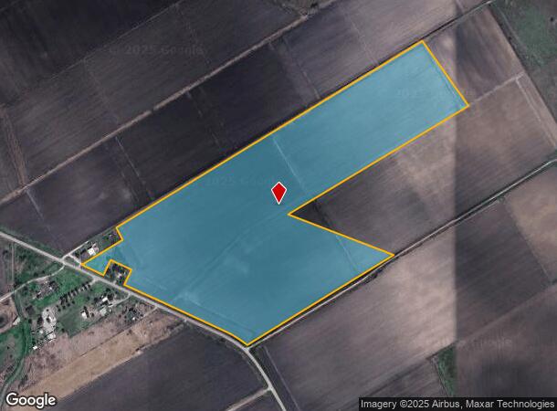
Property Record
Darst Rd, Beasley, TX 77417
NEARBY LISTINGS FOR SALE OR LEASE
Property Detail
Darst Rd
Houston-Pasadena-The Woodlands, TX
I Mcgary
0058-04-010-0000-908
0058 I MCGARY, ACRES 57.66
Farms
Fort Bend
X
Texas
48157C0375M
57.66 AC
2024
Southwest Outlier
2025
Houston
675800
DEMOGRAPHICS near Darst Rd
1 mile
3 mile
5 mile
2024 Total Population
153
790
3,972
2029 Population
176
907
4,557
Pop Growth 2024-2029
+ 15.03%
+ 14.81%
+ 14.73%
Average Age
41
41
40
2024 Total Households
53
279
1,368
HH Growth 2024-2029
+ 15.09%
+ 15.41%
+ 14.77%
Median Household Inc
$38,333
$39,899
$50,882
Avg Household Size
2.80
2.80
2.90
2024 Avg HH Vehicles
2.00
2.00
2.00
Median Home Value
$403,333
$220,833
$185,152
Median Year Built
1977
1975
1979
Nearby Places
Map Layers
Map Styles
 Street
 Aerial
Transit
 Traffic
 Biking
Places
Listings with unknown addresses are not visible on the map
- Restaurants
- Banks
- Shops
- Fitness
- Groceries
SALE & LEASE HISTORY
LISTING DATE
SALE/LEASE

Dec 21, 2017
For Sale
Nearby Properties
Address
Land Use
TOTAL SIZE
Lot Size
Zoning
Address
Land Use
TOTAL SIZE
Lot Size
Zoning
Address
Land Use
TOTAL SIZE
Lot Size
Zoning
828,228 SF
38.96 AC
Address
Land Use
TOTAL SIZE
Lot Size
Zoning
37.55 AC
Address
Land Use
TOTAL SIZE
Lot Size
Zoning
110,714 SF
14.34 AC
Address
Land Use
TOTAL SIZE
Lot Size
Zoning
140.86 AC
Address
Land Use
TOTAL SIZE
Lot Size
Zoning
386.32 AC
YSOM
Address
Land Use
TOTAL SIZE
Lot Size
Zoning
77.67 AC
OS
Address
Land Use
TOTAL SIZE
Lot Size
Zoning
56.70 AC
Z
Address
Land Use
TOTAL SIZE
Lot Size
Zoning
44,400 SF
70.82 AC
O
Address
Land Use
TOTAL SIZE
Lot Size
Zoning
234.20 AC
Address
Land Use
TOTAL SIZE
Lot Size
Zoning
Address
Land Use
TOTAL SIZE
Lot Size
Zoning
25 AC
R
Address
Land Use
TOTAL SIZE
Lot Size
Zoning
45.44 AC
OS
Address
Land Use
TOTAL SIZE
Lot Size
Zoning
2,304 SF
81.04 AC
TS
Address
Land Use
TOTAL SIZE
Lot Size
Zoning
3,864 SF
14.73 AC
SAY
Address
Land Use
TOTAL SIZE
Lot Size
Zoning
1,500 SF
0.32 AC
X
Address
Land Use
TOTAL SIZE
Lot Size
Zoning
56,353 SF
4.16 AC
Address
Land Use
TOTAL SIZE
Lot Size
Zoning
235.17 AC
T
Address
Land Use
TOTAL SIZE
Lot Size
Zoning
50.17 AC
Address
Land Use
TOTAL SIZE
Lot Size
Zoning
4,182 SF
0.99 AC
Address
Land Use
TOTAL SIZE
Lot Size
Zoning
48,900 SF
5.72 AC
Address
Land Use
TOTAL SIZE
Lot Size
Zoning
800 SF
10.41 AC
OY
Address
Land Use
TOTAL SIZE
Lot Size
Zoning
10.83 AC
S
Address
Land Use
TOTAL SIZE
Lot Size
Zoning
288.21 AC
Address
Land Use
TOTAL SIZE
Lot Size
Zoning
15.41 AC
Address
Land Use
TOTAL SIZE
Lot Size
Zoning
3,431 SF
10.83 AC
OS
Address
Land Use
TOTAL SIZE
Lot Size
Zoning
2,220 SF
2 AC
Address
Land Use
TOTAL SIZE
Lot Size
Zoning
3,302 SF
2.12 AC
Address
Land Use
TOTAL SIZE
Lot Size
Zoning
9.85 AC
S
Address
Land Use
TOTAL SIZE
Lot Size
Zoning
3,140 SF
3.27 AC
The World's #1 Commercial Real Estate Marketplace
Connect with us
© 2026 CoStar Group
The information above has been obtained from sources believed reliable. While we do not doubt its accuracy we have not verified it and make no guarantee, warranty or representation about it. It is your responsibility to independently confirm its accuracy and completeness. Any projections, opinions, assumptions, or estimates used are for example only and do not represent the current or future performance of the property. The value of this transaction to you depends on tax and other factors which should be evaluated by your tax, financial, and legal advisors. You and your advisors should conduct a careful, independent investigation of the property to determine to your satisfaction the suitability of the property for your needs.