Property Record
0 Deimling Rd, Perrysburg, OH 43551
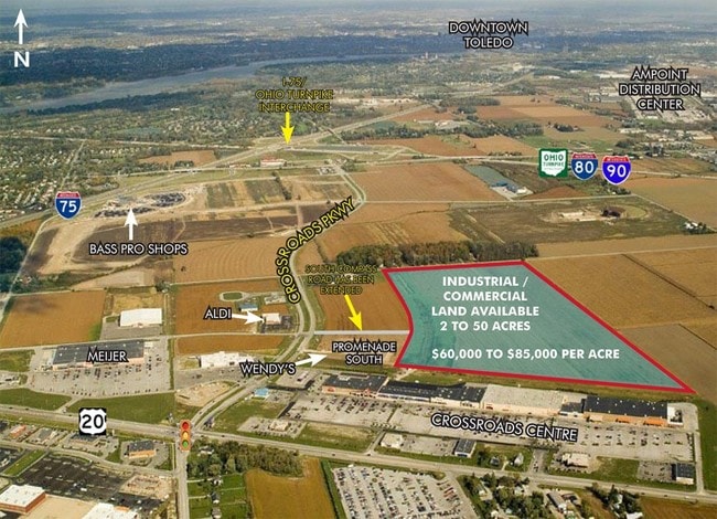

Property Detail
0 Deimling Rd
Toledo, OH
RD TR 9 N40A E100A TIF PARCEL 100% 2001-2030
T68-400-100000032000
WOOD
Commercialacreage
Ohio
B and X Area of moderate flood hazard, usually the area between the limits of the 100-year and 500-year floods.
39.77 AC
2025
Perrysburg/Northwood
2025
Toledo
020402
NEARBY LISTINGS FOR SALE OR LEASE
DEMOGRAPHICS near 0 Deimling Rd
1 mile
3 mile
5 mile
2025 Total Population
175
23,568
76,780
2030 Population
182
23,894
76,624
Pop Growth 2025-2030
+ 4.00%
+ 1.38%
(0.20%)
Average Age
43
41
41
2025 Total Households
73
10,290
33,343
HH Growth 2025-2030
+ 4.11%
+ 1.39%
(0.22%)
Median Household Inc
$82,353
$76,487
$75,169
Avg Household Size
2.20
2.20
2.30
2025 Avg HH Vehicles
2.00
2.00
2.00
Median Home Value
$269,230
$278,533
$199,301
Median Year Built
1980
1988
1970
Nearby Places
Map Layers
Map Styles
 Street
 Aerial
Layers
 Traffic
 Biking
Places
Listings with unknown addresses are not visible on the map
- Restaurants
- Banks
- Shops
- Fitness
- Groceries
PUBLIC TRANSPORTATION
AIRPORT
Eugene F Kranz Toledo Express
Drive
Walk
Distance
Eugene F Kranz Toledo Express
34 min
15.5 mi
Freight Ports
Port of Toledo
Drive
Walk
Distance
Port of Toledo
30 min
14.8 mi
Nearby Properties
Address
Land Use
TOTAL SIZE
Lot Size
Zoning
Address
Land Use
TOTAL SIZE
Lot Size
Zoning
288,140 SF
248.70 AC
Address
Land Use
TOTAL SIZE
Lot Size
Zoning
700,682 SF
100.30 AC
Address
Land Use
TOTAL SIZE
Lot Size
Zoning
1,445,856 SF
73.62 AC
Address
Land Use
TOTAL SIZE
Lot Size
Zoning
1,085,620 SF
76.95 AC
Address
Land Use
TOTAL SIZE
Lot Size
Zoning
598,713 SF
59.75 AC
Address
Land Use
TOTAL SIZE
Lot Size
Zoning
1,607,895 SF
8 AC
Address
Land Use
TOTAL SIZE
Lot Size
Zoning
788,541 SF
45.02 AC
Address
Land Use
TOTAL SIZE
Lot Size
Zoning
115,872 SF
10.12 AC
Address
Land Use
TOTAL SIZE
Lot Size
Zoning
211,020 SF
13.19 AC
Address
Land Use
TOTAL SIZE
Lot Size
Zoning
184,765 SF
12.91 AC
Address
Land Use
TOTAL SIZE
Lot Size
Zoning
71,040 SF
34.93 AC
Address
Land Use
TOTAL SIZE
Lot Size
Zoning
191,196 SF
25.90 AC
Address
Land Use
TOTAL SIZE
Lot Size
Zoning
661,200 SF
43.95 AC
Address
Land Use
TOTAL SIZE
Lot Size
Zoning
92,702 SF
4.61 AC
Address
Land Use
TOTAL SIZE
Lot Size
Zoning
2,135,540 SF
67.72 AC
Address
Land Use
TOTAL SIZE
Lot Size
Zoning
73,324 SF
16.80 AC
Address
Land Use
TOTAL SIZE
Lot Size
Zoning
392,037 SF
21.94 AC
Address
Land Use
TOTAL SIZE
Lot Size
Zoning
43,956 SF
11.68 AC
Address
Land Use
TOTAL SIZE
Lot Size
Zoning
80,668 SF
9.67 AC
Address
Land Use
TOTAL SIZE
Lot Size
Zoning
431,435 SF
13.74 AC
Address
Land Use
TOTAL SIZE
Lot Size
Zoning
100,446 SF
19.44 AC
Address
Land Use
TOTAL SIZE
Lot Size
Zoning
119,639 SF
11.52 AC
Address
Land Use
TOTAL SIZE
Lot Size
Zoning
189,974 SF
24.55 AC
Address
Land Use
TOTAL SIZE
Lot Size
Zoning
126,646 SF
16.27 AC
Address
Land Use
TOTAL SIZE
Lot Size
Zoning
75,770 SF
2.55 AC
Address
Land Use
TOTAL SIZE
Lot Size
Zoning
75,882 SF
19.08 AC
Address
Land Use
TOTAL SIZE
Lot Size
Zoning
36,646 SF
9.62 AC
Address
Land Use
TOTAL SIZE
Lot Size
Zoning
213,124 SF
23.27 AC
Address
Land Use
TOTAL SIZE
Lot Size
Zoning
91,596 SF
7.20 AC
Address
Land Use
TOTAL SIZE
Lot Size
Zoning
46,528 SF
1.75 AC
The World's #1 Commercial Real Estate Marketplace
Connect with us
© 2026 CoStar Group
The information above has been obtained from sources believed reliable. While we do not doubt its accuracy we have not verified it and make no guarantee, warranty or representation about it. It is your responsibility to independently confirm its accuracy and completeness. Any projections, opinions, assumptions, or estimates used are for example only and do not represent the current or future performance of the property. The value of this transaction to you depends on tax and other factors which should be evaluated by your tax, financial, and legal advisors. You and your advisors should conduct a careful, independent investigation of the property to determine to your satisfaction the suitability of the property for your needs.