Property Record
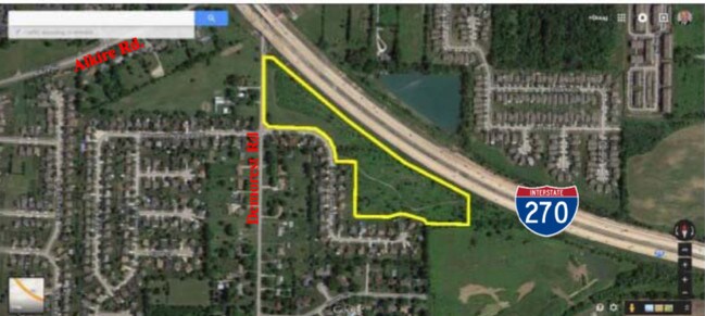
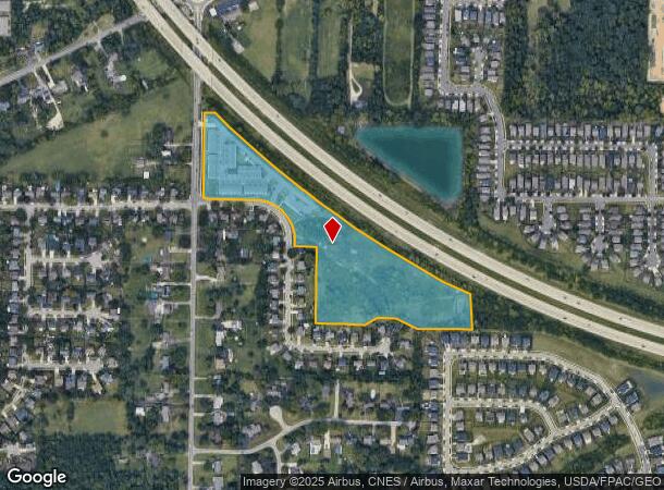
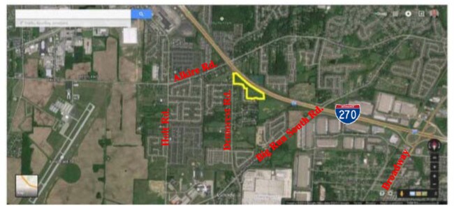
0 Demorest Rd, Columbus Grove, OH 45830
NEARBY LISTINGS FOR SALE OR LEASE
Property Detail
0 Demorest Rd
570-139944
Demorest Cove
Apartment
DEMOREST RD ENTRY 1389 16.099 ACRES
X
Franklin
39049C0311K
Ohio
2024
16.10 AC
2024
Southwest
030500
Columbus
17,680 SF
Columbus, OH
DEMOGRAPHICS near 0 Demorest Rd
1 Mile
3 Mile
5 Mile
2024 Total Population
10,826
100,000
191,560
2029 Population
10,745
99,898
192,255
Pop Growth 2024-2029
(0.75%)
(0.10%)
+ 0.36%
Average Age
37
37
37
2024 Total Households
4,343
38,235
73,021
HH Growth 2024-2029
(0.83%)
(0.18%)
+ 0.28%
Median Household Inc
$72,784
$59,360
$61,347
Avg Household Size
2.40
2.50
2.50
2024 Avg HH Vehicles
2.00
2.00
2.00
Median Home Value
$200,777
$177,318
$188,371
Median Year Built
1997
1977
1978
Nearby Places
Map Layers
Map Styles
 Street
 Aerial
- Restaurants
- Banks
- Shops
- Fitness
- Groceries
PUBLIC TRANSPORTATION
AIRPORT
John Glenn Columbus International
DRIVE
WALK
Distance
John Glenn Columbus International
27 min
15.4 mi
Rickenbacker International
DRIVE
WALK
Distance
Rickenbacker International
26 min
16.0 mi
Freight Ports
Port of Toledo
DRIVE
WALK
Distance
Port of Toledo
190 min
140.0 mi
SALE & LEASE HISTORY
LISTING DATE
SALE/LEASE

Sep 24, 2016
For Sale
Nov 29, 2017
For Sale
Nearby Properties
Address
Land Use
TOTAL SIZE
Lot Size
Zoning
Address
Land Use
TOTAL SIZE
Lot Size
Zoning
1,215,421 SF
108.07 AC
Address
Land Use
TOTAL SIZE
Lot Size
Zoning
470,659 SF
101.09 AC
Address
Land Use
TOTAL SIZE
Lot Size
Zoning
210,724 SF
43.38 AC
Address
Land Use
TOTAL SIZE
Lot Size
Zoning
257,723 SF
38.06 AC
Address
Land Use
TOTAL SIZE
Lot Size
Zoning
1,178,014 SF
152.63 AC
Address
Land Use
TOTAL SIZE
Lot Size
Zoning
170,028 SF
13.66 AC
Address
Land Use
TOTAL SIZE
Lot Size
Zoning
472,671 SF
70.36 AC
Address
Land Use
TOTAL SIZE
Lot Size
Zoning
1,011,597 SF
49.94 AC
Address
Land Use
TOTAL SIZE
Lot Size
Zoning
749,152 SF
41.23 AC
Address
Land Use
TOTAL SIZE
Lot Size
Zoning
128,263 SF
6.59 AC
Address
Land Use
TOTAL SIZE
Lot Size
Zoning
247,354 SF
30.38 AC
Address
Land Use
TOTAL SIZE
Lot Size
Zoning
110,590 SF
13.44 AC
Address
Land Use
TOTAL SIZE
Lot Size
Zoning
332,176 SF
24.52 AC
Address
Land Use
TOTAL SIZE
Lot Size
Zoning
493,000 SF
29.55 AC
Address
Land Use
TOTAL SIZE
Lot Size
Zoning
759,600 SF
23.75 AC
Address
Land Use
TOTAL SIZE
Lot Size
Zoning
122,159 SF
2.77 AC
Address
Land Use
TOTAL SIZE
Lot Size
Zoning
202,330 SF
18.89 AC
Address
Land Use
TOTAL SIZE
Lot Size
Zoning
117,389 SF
177.98 AC
Address
Land Use
TOTAL SIZE
Lot Size
Zoning
178,452 SF
34.84 AC
Address
Land Use
TOTAL SIZE
Lot Size
Zoning
322,000 SF
18.83 AC
Address
Land Use
TOTAL SIZE
Lot Size
Zoning
542,043 SF
30.41 AC
Address
Land Use
TOTAL SIZE
Lot Size
Zoning
18,823 SF
14.73 AC
Address
Land Use
TOTAL SIZE
Lot Size
Zoning
377,124 SF
19.58 AC
Address
Land Use
TOTAL SIZE
Lot Size
Zoning
399,784 SF
20.86 AC
Address
Land Use
TOTAL SIZE
Lot Size
Zoning
52,283 SF
19.41 AC
Address
Land Use
TOTAL SIZE
Lot Size
Zoning
94,593 SF
7.97 AC
Address
Land Use
TOTAL SIZE
Lot Size
Zoning
61,595 SF
9.75 AC
Address
Land Use
TOTAL SIZE
Lot Size
Zoning
221,616 SF
10.62 AC
Address
Land Use
TOTAL SIZE
Lot Size
Zoning
81,687 SF
10.19 AC
Address
Land Use
TOTAL SIZE
Lot Size
Zoning
75,164 SF
16.26 AC
The World's #1 Commercial Real Estate Marketplace
Connect with us
© 2025 CoStar Group
The information above has been obtained from sources believed reliable. While we do not doubt its accuracy we have not verified it and make no guarantee, warranty or representation about it. It is your responsibility to independently confirm its accuracy and completeness. Any projections, opinions, assumptions, or estimates used are for example only and do not represent the current or future performance of the property. The value of this transaction to you depends on tax and other factors which should be evaluated by your tax, financial, and legal advisors. You and your advisors should conduct a careful, independent investigation of the property to determine to your satisfaction the suitability of the property for your needs.