Property Record
0 Dunn Ave, Jacksonville, FL 32219
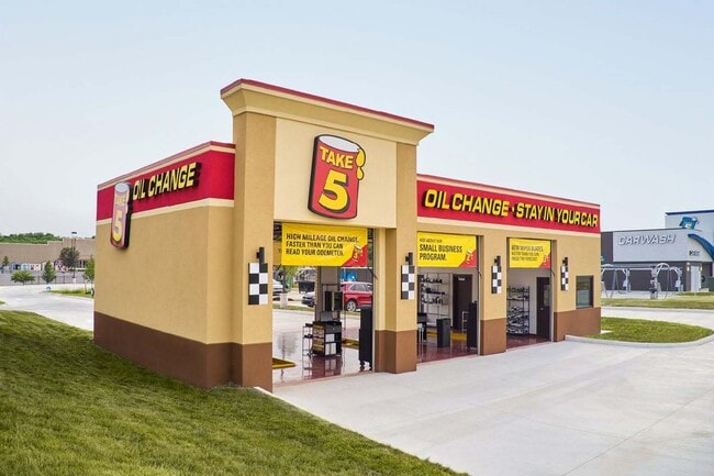
This Property Is For Sale
NEARBY LISTINGS FOR SALE OR LEASE
Property Detail
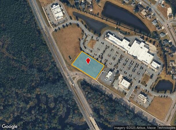
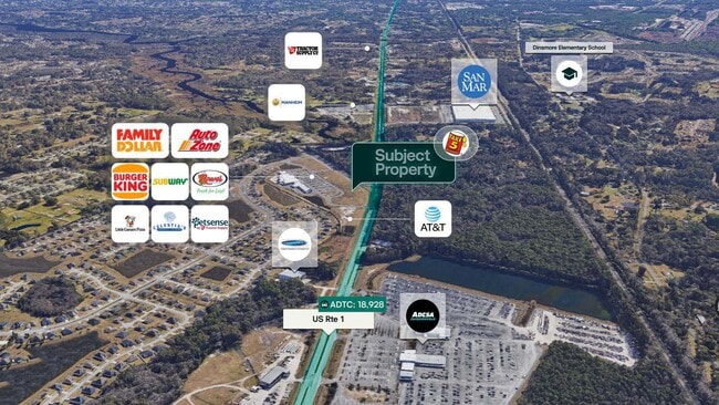
0 Dunn Ave
Jacksonville (Florida)
Dinsmore Farms S/D Sec
Jacksonville, FL
41-1S-25E 1.41 DINSMORE FARMS PT FARM 63 RECD O/R 21400-778
003809-0275
Duval
Commercialacreage
Florida
2024
1.43 AC
2025
Northwest Jacksonville
010601
DEMOGRAPHICS near 0 Dunn Ave
1 Mile
3 Mile
5 Mile
2024 Total Population
3,033
18,701
54,865
2029 Population
3,272
20,146
58,808
Pop Growth 2024-2029
+ 7.88%
+ 7.73%
+ 7.19%
Average Age
38
39
40
2024 Total Households
1,083
6,777
20,328
HH Growth 2024-2029
+ 8.22%
+ 7.98%
+ 7.41%
Median Household Inc
$82,413
$73,483
$62,098
Avg Household Size
2.70
2.70
2.60
2024 Avg HH Vehicles
2.00
2.00
2.00
Median Home Value
$274,999
$278,586
$249,100
Median Year Built
2006
2000
1987
Nearby Places
Map Layers
Map Styles
 Street
 Aerial
- Restaurants
- Banks
- Shops
- Fitness
- Groceries
PUBLIC TRANSPORTATION
COMMUTER RAIL
Jacksonville (Silver Meteor - Amtrak, Silver Star - Amtrak)
DRIVE
WALK
Distance
Jacksonville (Silver Meteor - Amtrak, Silver Star - Amtrak)
11 min
6.2 mi
AIRPORT
Jacksonville International
DRIVE
WALK
Distance
Jacksonville International
19 min
10.1 mi
Freight Ports
Jacksonville Port
DRIVE
WALK
Distance
Jacksonville Port
22 min
12.4 mi
Nearby Properties
Address
Land Use
TOTAL SIZE
Lot Size
Zoning
Address
Land Use
TOTAL SIZE
Lot Size
Zoning
647,378 SF
27.72 AC
IBP
Address
Land Use
TOTAL SIZE
Lot Size
Zoning
375,130 SF
25.22 AC
IBP
Address
Land Use
TOTAL SIZE
Lot Size
Zoning
6,300 SF
744.81 AC
PUD
Address
Land Use
TOTAL SIZE
Lot Size
Zoning
225,829 SF
140.47 AC
PBF-1
Address
Land Use
TOTAL SIZE
Lot Size
Zoning
39,251 SF
55.24 AC
PUD
Address
Land Use
TOTAL SIZE
Lot Size
Zoning
157,948 SF
9.02 AC
PUD
Address
Land Use
TOTAL SIZE
Lot Size
Zoning
79,407 SF
14.93 AC
PUD
Address
Land Use
TOTAL SIZE
Lot Size
Zoning
254.45 AC
PUD
Address
Land Use
TOTAL SIZE
Lot Size
Zoning
49,120 SF
89.32 AC
CCG-2
Address
Land Use
TOTAL SIZE
Lot Size
Zoning
1,950 SF
72.15 AC
IBP
Address
Land Use
TOTAL SIZE
Lot Size
Zoning
74,680 SF
5.07 AC
PUD
Address
Land Use
TOTAL SIZE
Lot Size
Zoning
17,698 SF
2.11 AC
CCG-1
Address
Land Use
TOTAL SIZE
Lot Size
Zoning
66.30 AC
PUD
Address
Land Use
TOTAL SIZE
Lot Size
Zoning
66,255 SF
40.55 AC
RR-ACRE
Address
Land Use
TOTAL SIZE
Lot Size
Zoning
13,214 SF
1.52 AC
PUD
Address
Land Use
TOTAL SIZE
Lot Size
Zoning
58,475 SF
5.33 AC
PUD
Address
Land Use
TOTAL SIZE
Lot Size
Zoning
170.39 AC
PUD
Address
Land Use
TOTAL SIZE
Lot Size
Zoning
2,216 SF
275.40 AC
PUD
Address
Land Use
TOTAL SIZE
Lot Size
Zoning
16,030 SF
0.06 AC
CCG-1
Address
Land Use
TOTAL SIZE
Lot Size
Zoning
792 SF
9.18 AC
ROS
Address
Land Use
TOTAL SIZE
Lot Size
Zoning
16,110 SF
0.06 AC
CCG-1
Address
Land Use
TOTAL SIZE
Lot Size
Zoning
14,880 SF
0.06 AC
CCG-1
Address
Land Use
TOTAL SIZE
Lot Size
Zoning
15,738 SF
9.70 AC
RR-ACRE
Address
Land Use
TOTAL SIZE
Lot Size
Zoning
19,375 SF
3.01 AC
PUD
Address
Land Use
TOTAL SIZE
Lot Size
Zoning
47.16 AC
PUD
Address
Land Use
TOTAL SIZE
Lot Size
Zoning
28,799 SF
14.33 AC
PUD
Address
Land Use
TOTAL SIZE
Lot Size
Zoning
5,584 SF
254.18 AC
IL
Address
Land Use
TOTAL SIZE
Lot Size
Zoning
34,337 SF
23.09 AC
IL
Address
Land Use
TOTAL SIZE
Lot Size
Zoning
131.41 AC
PUD
Address
Land Use
TOTAL SIZE
Lot Size
Zoning
12,963 SF
3.74 AC
CCG-2
The World's #1 Commercial Real Estate Marketplace
Connect with us
© 2026 CoStar Group
The information above has been obtained from sources believed reliable. While we do not doubt its accuracy we have not verified it and make no guarantee, warranty or representation about it. It is your responsibility to independently confirm its accuracy and completeness. Any projections, opinions, assumptions, or estimates used are for example only and do not represent the current or future performance of the property. The value of this transaction to you depends on tax and other factors which should be evaluated by your tax, financial, and legal advisors. You and your advisors should conduct a careful, independent investigation of the property to determine to your satisfaction the suitability of the property for your needs.