Property Record
0 E James Rd, Columbus Grove, OH 45830
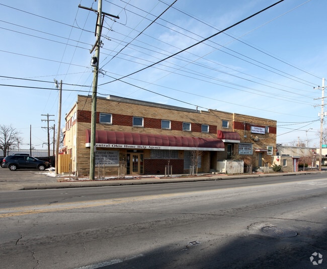


Property Detail
0 E James Rd
010-091795
S JAMES RD R21 T12 S18 1/2S30 0.6496 ACRE
Storebuilding
FRANKLIN
B and X Area of moderate flood hazard, usually the area between the limits of the 100-year and 500-year floods.
Ohio
2024
0.65 AC
2025
East
030500
Columbus
5,709 SF
Columbus, OH
NEARBY LISTINGS FOR SALE OR LEASE
DEMOGRAPHICS near 0 E James Rd
1 mile
3 mile
5 mile
2025 Total Population
19,094
123,832
295,349
2030 Population
19,703
129,073
307,512
Pop Growth 2025-2030
+ 3.19%
+ 4.23%
+ 4.12%
Average Age
39
38
38
2025 Total Households
7,969
51,664
127,173
HH Growth 2025-2030
+ 3.39%
+ 4.52%
+ 4.36%
Median Household Inc
$55,790
$50,843
$55,707
Avg Household Size
2.30
2.30
2.20
2025 Avg HH Vehicles
1.00
1.00
1.00
Median Home Value
$289,075
$230,047
$239,963
Median Year Built
1955
1960
1966
Nearby Places
Map Layers
Map Styles
 Street
 Aerial
Transit
 Traffic
 Biking
Places
Listings with unknown addresses are not visible on the map
- Restaurants
- Banks
- Shops
- Fitness
- Groceries
PUBLIC TRANSPORTATION
AIRPORT
John Glenn Columbus International
Drive
Walk
Distance
John Glenn Columbus International
8 min
4.2 mi
Rickenbacker International
Drive
Walk
Distance
Rickenbacker International
18 min
11.3 mi
SALE & LEASE HISTORY
LISTING DATE
SALE/LEASE

Oct 05, 2018
For Sale
Nearby Properties
Address
Land Use
TOTAL SIZE
Lot Size
Zoning
Address
Land Use
TOTAL SIZE
Lot Size
Zoning
316,415 SF
415.78 AC
Address
Land Use
TOTAL SIZE
Lot Size
Zoning
180,383 SF
15.54 AC
Address
Land Use
TOTAL SIZE
Lot Size
Zoning
184,777 SF
3.67 AC
Address
Land Use
TOTAL SIZE
Lot Size
Zoning
573,031 SF
5.88 AC
Address
Land Use
TOTAL SIZE
Lot Size
Zoning
301,882 SF
1.13 AC
Address
Land Use
TOTAL SIZE
Lot Size
Zoning
360,962 SF
33.91 AC
Address
Land Use
TOTAL SIZE
Lot Size
Zoning
299,220 SF
29.68 AC
Address
Land Use
TOTAL SIZE
Lot Size
Zoning
183,352 SF
55.41 AC
Address
Land Use
TOTAL SIZE
Lot Size
Zoning
282,035 SF
29.29 AC
Address
Land Use
TOTAL SIZE
Lot Size
Zoning
332,616 SF
26.90 AC
Address
Land Use
TOTAL SIZE
Lot Size
Zoning
209,542 SF
27.50 AC
Address
Land Use
TOTAL SIZE
Lot Size
Zoning
398,836 SF
14.37 AC
Address
Land Use
TOTAL SIZE
Lot Size
Zoning
238,624 SF
6.38 AC
Address
Land Use
TOTAL SIZE
Lot Size
Zoning
143,397 SF
25.50 AC
Address
Land Use
TOTAL SIZE
Lot Size
Zoning
245,142 SF
11.56 AC
Address
Land Use
TOTAL SIZE
Lot Size
Zoning
175,884 SF
4.42 AC
Address
Land Use
TOTAL SIZE
Lot Size
Zoning
163,713 SF
69.84 AC
Address
Land Use
TOTAL SIZE
Lot Size
Zoning
66,177 SF
11.17 AC
Address
Land Use
TOTAL SIZE
Lot Size
Zoning
706,471 SF
41.34 AC
Address
Land Use
TOTAL SIZE
Lot Size
Zoning
217,088 SF
10.67 AC
Address
Land Use
TOTAL SIZE
Lot Size
Zoning
205,370 SF
19.82 AC
Address
Land Use
TOTAL SIZE
Lot Size
Zoning
125,035 SF
9.12 AC
Address
Land Use
TOTAL SIZE
Lot Size
Zoning
1,264,151 SF
58.42 AC
Address
Land Use
TOTAL SIZE
Lot Size
Zoning
386,669 SF
32.15 AC
Address
Land Use
TOTAL SIZE
Lot Size
Zoning
125,219 SF
3.49 AC
Address
Land Use
TOTAL SIZE
Lot Size
Zoning
142,542 SF
6.55 AC
Address
Land Use
TOTAL SIZE
Lot Size
Zoning
142,542 SF
3.95 AC
Address
Land Use
TOTAL SIZE
Lot Size
Zoning
158,325 SF
34.39 AC
Address
Land Use
TOTAL SIZE
Lot Size
Zoning
102,412 SF
11.86 AC
Address
Land Use
TOTAL SIZE
Lot Size
Zoning
267,596 SF
5.76 AC
The World's #1 Commercial Real Estate Marketplace
Connect with us
© 2026 CoStar Group
The information above has been obtained from sources believed reliable. While we do not doubt its accuracy we have not verified it and make no guarantee, warranty or representation about it. It is your responsibility to independently confirm its accuracy and completeness. Any projections, opinions, assumptions, or estimates used are for example only and do not represent the current or future performance of the property. The value of this transaction to you depends on tax and other factors which should be evaluated by your tax, financial, and legal advisors. You and your advisors should conduct a careful, independent investigation of the property to determine to your satisfaction the suitability of the property for your needs.