Property Record
0 E Madison St, La Porte, TX 77571


Property Detail
0 E Madison St
Houston-Pasadena-The Woodlands, TX
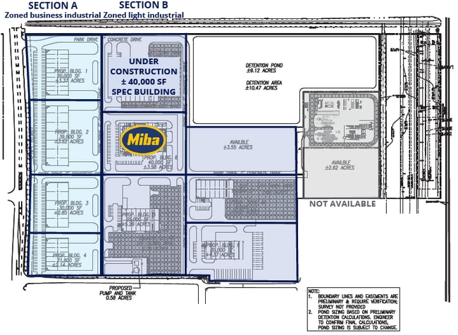
LTS 1 THRU 32 & TR D BLKS 620 THRU 625 & LTS 17 THRU 32 & TRS 1 THRU 16 BLK 626 & LTS 17 THRU 32 & TRS 1 THRU 16 BLK 635 LTS 1 THRU 32 BLKS 636 THRU 641 &
0240630200001
HARRIS
Outdoorrecreationbeachmountaindesert
Texas
AE The base floodplain where base flood elevations are provided. AE Zones are now used on new format FIRMs instead of A1-A30 Zones.
1
2024
60.87 AC
2025
East-Southeast Far
343200
Houston
NEARBY LISTINGS FOR SALE OR LEASE
DEMOGRAPHICS near 0 E Madison St
1 mile
3 mile
5 mile
2025 Total Population
3,395
30,947
72,868
2030 Population
3,701
33,239
77,954
Pop Growth 2025-2030
+ 9.01%
+ 7.41%
+ 6.98%
Average Age
39
39
39
2025 Total Households
1,188
11,055
25,979
HH Growth 2025-2030
+ 9.01%
+ 7.33%
+ 7.07%
Median Household Inc
$115,108
$95,397
$92,127
Avg Household Size
2.90
2.70
2.80
2025 Avg HH Vehicles
3.00
2.00
2.00
Median Home Value
$277,260
$256,037
$267,100
Median Year Built
1996
1986
1985
Nearby Places
Map Layers
Map Styles
 Street
 Aerial
Transit
 Traffic
 Biking
Places
Listings with unknown addresses are not visible on the map
- Restaurants
- Banks
- Shops
- Fitness
- Groceries
PUBLIC TRANSPORTATION
AIRPORT
William P Hobby
Drive
Walk
Distance
William P Hobby
33 min
17.2 mi
George Bush Intcntl/Houston
Drive
Walk
Distance
George Bush Intcntl/Houston
46 min
35.5 mi
Freight Ports
Port of Houston
Drive
Walk
Distance
Port of Houston
28 min
18.4 mi
SALE & LEASE HISTORY
LISTING DATE
SALE/LEASE

May 21, 2025
For Lease
Nearby Properties
Address
Land Use
TOTAL SIZE
Lot Size
Zoning
Address
Land Use
TOTAL SIZE
Lot Size
Zoning
45.75 AC
Address
Land Use
TOTAL SIZE
Lot Size
Zoning
45.78 AC
Address
Land Use
TOTAL SIZE
Lot Size
Zoning
36.31 AC
Address
Land Use
TOTAL SIZE
Lot Size
Zoning
38.27 AC
Address
Land Use
TOTAL SIZE
Lot Size
Zoning
47.21 AC
Address
Land Use
TOTAL SIZE
Lot Size
Zoning
Address
Land Use
TOTAL SIZE
Lot Size
Zoning
156.07 AC
Address
Land Use
TOTAL SIZE
Lot Size
Zoning
61.40 AC
Address
Land Use
TOTAL SIZE
Lot Size
Zoning
Address
Land Use
TOTAL SIZE
Lot Size
Zoning
46.10 AC
Address
Land Use
TOTAL SIZE
Lot Size
Zoning
767,630 SF
41.71 AC
Address
Land Use
TOTAL SIZE
Lot Size
Zoning
1,120,800 SF
35.24 AC
Address
Land Use
TOTAL SIZE
Lot Size
Zoning
711,094 SF
35.47 AC
Address
Land Use
TOTAL SIZE
Lot Size
Zoning
748,500 SF
42.13 AC
Address
Land Use
TOTAL SIZE
Lot Size
Zoning
610,402 SF
34.69 AC
Address
Land Use
TOTAL SIZE
Lot Size
Zoning
602,060 SF
34.15 AC
Address
Land Use
TOTAL SIZE
Lot Size
Zoning
30.58 AC
Address
Land Use
TOTAL SIZE
Lot Size
Zoning
348,294 SF
18.02 AC
Address
Land Use
TOTAL SIZE
Lot Size
Zoning
102.68 AC
Address
Land Use
TOTAL SIZE
Lot Size
Zoning
287,729 SF
20 AC
Address
Land Use
TOTAL SIZE
Lot Size
Zoning
416,005 SF
21.47 AC
Address
Land Use
TOTAL SIZE
Lot Size
Zoning
415,662 SF
21.49 AC
Address
Land Use
TOTAL SIZE
Lot Size
Zoning
403,572 SF
24.68 AC
Address
Land Use
TOTAL SIZE
Lot Size
Zoning
371,072 SF
19.71 AC
Address
Land Use
TOTAL SIZE
Lot Size
Zoning
45.18 AC
Address
Land Use
TOTAL SIZE
Lot Size
Zoning
26.28 AC
Address
Land Use
TOTAL SIZE
Lot Size
Zoning
95.07 AC
Address
Land Use
TOTAL SIZE
Lot Size
Zoning
365,728 SF
25.30 AC
Address
Land Use
TOTAL SIZE
Lot Size
Zoning
306,482 SF
22.96 AC
Address
Land Use
TOTAL SIZE
Lot Size
Zoning
26.32 AC
The World's #1 Commercial Real Estate Marketplace
Connect with us
© 2026 CoStar Group
The information above has been obtained from sources believed reliable. While we do not doubt its accuracy we have not verified it and make no guarantee, warranty or representation about it. It is your responsibility to independently confirm its accuracy and completeness. Any projections, opinions, assumptions, or estimates used are for example only and do not represent the current or future performance of the property. The value of this transaction to you depends on tax and other factors which should be evaluated by your tax, financial, and legal advisors. You and your advisors should conduct a careful, independent investigation of the property to determine to your satisfaction the suitability of the property for your needs.