Property Record
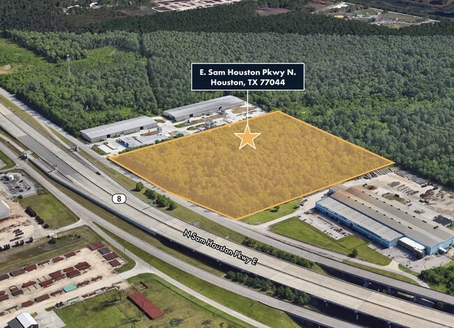
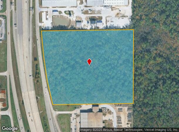
0 E Sam Housto Pkwy N, Houston, TX 77044
This Property Is For Sale
NEARBY LISTINGS FOR SALE OR LEASE
Property Detail
0 E Sam Housto Pkwy N
Houston-The Woodlands-Sugar Land, TX
Abst 263 J Flanders
0421240000117
TR 12D ABST 263 J FLANDERS
Agriculturalland
Harris
X
Texas
48201C0710M
19.80 AC
2024
Northeast Outlier
2025
Houston
252002
DEMOGRAPHICS near 0 E Sam Housto Pkwy N
1 Mile
3 Mile
5 Mile
2024 Total Population
7,289
53,656
153,234
2029 Population
7,536
55,095
156,468
Pop Growth 2024-2029
+ 3.39%
+ 2.68%
+ 2.11%
Average Age
32
33
34
2024 Total Households
2,099
16,015
46,291
HH Growth 2024-2029
+ 3.29%
+ 2.61%
+ 2.03%
Median Household Inc
$68,600
$57,736
$53,645
Avg Household Size
3.40
3.30
3.20
2024 Avg HH Vehicles
2.00
2.00
2.00
Median Home Value
$154,896
$158,834
$158,582
Median Year Built
2004
2002
1989
Nearby Places
Map Layers
Map Styles
 Street
 Aerial
- Restaurants
- Banks
- Shops
- Fitness
- Groceries
PUBLIC TRANSPORTATION
AIRPORT
George Bush Intcntl/Houston
DRIVE
WALK
Distance
George Bush Intcntl/Houston
20 min
17.0 mi
William P Hobby
DRIVE
WALK
Distance
William P Hobby
35 min
20.3 mi
Freight Ports
Port of Houston
DRIVE
WALK
Distance
Port of Houston
21 min
12.2 mi
Nearby Properties
Address
Land Use
TOTAL SIZE
Lot Size
Zoning
Address
Land Use
TOTAL SIZE
Lot Size
Zoning
1,403,952 SF
48.81 AC
Address
Land Use
TOTAL SIZE
Lot Size
Zoning
337,331 SF
56.09 AC
Address
Land Use
TOTAL SIZE
Lot Size
Zoning
699,448 SF
46.40 AC
Address
Land Use
TOTAL SIZE
Lot Size
Zoning
671,363 SF
61.27 AC
Address
Land Use
TOTAL SIZE
Lot Size
Zoning
331,284 SF
15.15 AC
Address
Land Use
TOTAL SIZE
Lot Size
Zoning
277,486 SF
15.42 AC
Address
Land Use
TOTAL SIZE
Lot Size
Zoning
271,428 SF
10.57 AC
Address
Land Use
TOTAL SIZE
Lot Size
Zoning
225,124 SF
10.20 AC
Address
Land Use
TOTAL SIZE
Lot Size
Zoning
315,000 SF
21.47 AC
Address
Land Use
TOTAL SIZE
Lot Size
Zoning
248,293 SF
13.20 AC
Address
Land Use
TOTAL SIZE
Lot Size
Zoning
212,558 SF
52.87 AC
Address
Land Use
TOTAL SIZE
Lot Size
Zoning
824,156 SF
53.31 AC
Address
Land Use
TOTAL SIZE
Lot Size
Zoning
168,348 SF
108.41 AC
Address
Land Use
TOTAL SIZE
Lot Size
Zoning
227,679 SF
13.31 AC
Address
Land Use
TOTAL SIZE
Lot Size
Zoning
110,900 SF
18.01 AC
Address
Land Use
TOTAL SIZE
Lot Size
Zoning
260,792 SF
206.39 AC
Address
Land Use
TOTAL SIZE
Lot Size
Zoning
537,768 SF
12.46 AC
Address
Land Use
TOTAL SIZE
Lot Size
Zoning
197,953 SF
8.29 AC
Address
Land Use
TOTAL SIZE
Lot Size
Zoning
48.81 AC
Address
Land Use
TOTAL SIZE
Lot Size
Zoning
80,653 SF
60.20 AC
Address
Land Use
TOTAL SIZE
Lot Size
Zoning
223,872 SF
Address
Land Use
TOTAL SIZE
Lot Size
Zoning
174,606 SF
55.34 AC
Address
Land Use
TOTAL SIZE
Lot Size
Zoning
198,306 SF
8.41 AC
Address
Land Use
TOTAL SIZE
Lot Size
Zoning
296,173 SF
16.33 AC
Address
Land Use
TOTAL SIZE
Lot Size
Zoning
935,563 SF
41.25 AC
Address
Land Use
TOTAL SIZE
Lot Size
Zoning
119,917 SF
4.63 AC
Address
Land Use
TOTAL SIZE
Lot Size
Zoning
158,856 SF
16.04 AC
Address
Land Use
TOTAL SIZE
Lot Size
Zoning
98,793 SF
10.02 AC
Address
Land Use
TOTAL SIZE
Lot Size
Zoning
113,290 SF
30.61 AC
Address
Land Use
TOTAL SIZE
Lot Size
Zoning
113,564 SF
8.77 AC
The World's #1 Commercial Real Estate Marketplace
Connect with us
© 2025 CoStar Group
The information above has been obtained from sources believed reliable. While we do not doubt its accuracy we have not verified it and make no guarantee, warranty or representation about it. It is your responsibility to independently confirm its accuracy and completeness. Any projections, opinions, assumptions, or estimates used are for example only and do not represent the current or future performance of the property. The value of this transaction to you depends on tax and other factors which should be evaluated by your tax, financial, and legal advisors. You and your advisors should conduct a careful, independent investigation of the property to determine to your satisfaction the suitability of the property for your needs.