Property Record
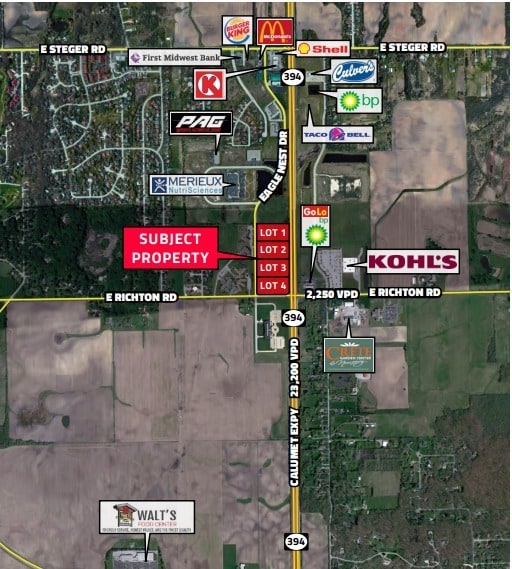
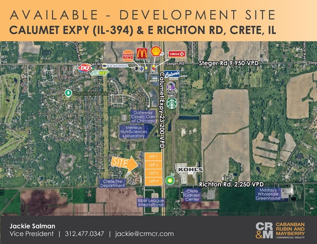
Eagle Nest Dr, Crete, IL 60417
Current Lease Availabilities
NEARBY LISTINGS FOR SALE OR LEASE
Property Detail
Eagle Nest Dr
Chicago-Naperville-Elgin, IL-IN-WI
Fscsc Development
23-15-02-404-002-0020
LOT 1 IN FSCSC DEVELOPMENT, BEING A SUB OF PRT OF THE SE1/4 OF SEC 2, T34N-R14E.
Commercialacreage
Will
X
Illinois
17197C0379G
1
2024
3.13 AC
2024
Far South
883811
Chicago
DEMOGRAPHICS near Eagle Nest Dr
1 Mile
3 Mile
5 Mile
2024 Total Population
2,269
23,807
84,789
2029 Population
2,251
23,586
84,536
Pop Growth 2024-2029
(0.79%)
(0.93%)
(0.30%)
Average Age
46
41
40
2024 Total Households
842
8,528
30,910
HH Growth 2024-2029
(0.83%)
(1.08%)
(0.49%)
Median Household Inc
$87,171
$67,668
$66,233
Avg Household Size
2.50
2.70
2.70
2024 Avg HH Vehicles
2.00
2.00
2.00
Median Home Value
$189,496
$164,869
$191,967
Median Year Built
1982
1974
1975
Nearby Places
- Restaurants
- Banks
- Shops
- Fitness
- Groceries
PUBLIC TRANSPORTATION
COMMUTER RAIL
Dyer Amtrak (Cardinal - Amtrak)
DRIVE
WALK
Distance
Dyer Amtrak (Cardinal - Amtrak)
14 min
6.9 mi
Matteson Station (Metra Electric Line - Northeast Illinois Regional Commuter Railroad (Metra))
DRIVE
WALK
Distance
Matteson Station (Metra Electric Line - Northeast Illinois Regional Commuter Railroad (Metra))
19 min
9.2 mi
AIRPORT
Chicago Midway International
DRIVE
WALK
Distance
Chicago Midway International
45 min
30.8 mi
Freight Ports
Port Milwaukee
DRIVE
WALK
Distance
Port Milwaukee
148 min
117.1 mi
Nearby Properties
Address
Land Use
TOTAL SIZE
Lot Size
Zoning
Address
Land Use
TOTAL SIZE
Lot Size
Zoning
90,526 SF
22.99 AC
R33
Address
Land Use
TOTAL SIZE
Lot Size
Zoning
49,866 SF
5.57 AC
Address
Land Use
TOTAL SIZE
Lot Size
Zoning
87,105 SF
7.74 AC
Address
Land Use
TOTAL SIZE
Lot Size
Zoning
304,256 SF
21.50 AC
Address
Land Use
TOTAL SIZE
Lot Size
Zoning
64,295 SF
2.23 AC
Address
Land Use
TOTAL SIZE
Lot Size
Zoning
26.61 AC
Address
Land Use
TOTAL SIZE
Lot Size
Zoning
628 SF
4.91 AC
Address
Land Use
TOTAL SIZE
Lot Size
Zoning
36.48 AC
Address
Land Use
TOTAL SIZE
Lot Size
Zoning
562,369 SF
50 AC
Address
Land Use
TOTAL SIZE
Lot Size
Zoning
Address
Land Use
TOTAL SIZE
Lot Size
Zoning
35.43 AC
Address
Land Use
TOTAL SIZE
Lot Size
Zoning
Address
Land Use
TOTAL SIZE
Lot Size
Zoning
85,231 SF
14.72 AC
Address
Land Use
TOTAL SIZE
Lot Size
Zoning
4,528 SF
43.65 AC
Address
Land Use
TOTAL SIZE
Lot Size
Zoning
269,840 SF
16.04 AC
Address
Land Use
TOTAL SIZE
Lot Size
Zoning
119,200 SF
11.12 AC
Address
Land Use
TOTAL SIZE
Lot Size
Zoning
68,315 SF
5.31 AC
Address
Land Use
TOTAL SIZE
Lot Size
Zoning
377,200 SF
18.90 AC
Address
Land Use
TOTAL SIZE
Lot Size
Zoning
17,931 SF
32.75 AC
Address
Land Use
TOTAL SIZE
Lot Size
Zoning
11.87 AC
Address
Land Use
TOTAL SIZE
Lot Size
Zoning
221,842 SF
30.94 AC
Address
Land Use
TOTAL SIZE
Lot Size
Zoning
118,135 SF
9.42 AC
Address
Land Use
TOTAL SIZE
Lot Size
Zoning
40 AC
Address
Land Use
TOTAL SIZE
Lot Size
Zoning
5,724 SF
3.31 AC
Address
Land Use
TOTAL SIZE
Lot Size
Zoning
20,885 SF
5.02 AC
Address
Land Use
TOTAL SIZE
Lot Size
Zoning
Address
Land Use
TOTAL SIZE
Lot Size
Zoning
4,597 SF
5.18 AC
Address
Land Use
TOTAL SIZE
Lot Size
Zoning
3,795 SF
6 AC
Address
Land Use
TOTAL SIZE
Lot Size
Zoning
3,058 SF
40 AC
Address
Land Use
TOTAL SIZE
Lot Size
Zoning
34.26 AC
The World's #1 Commercial Real Estate Marketplace
Connect with us
© 2025 CoStar Group
The information above has been obtained from sources believed reliable. While we do not doubt its accuracy we have not verified it and make no guarantee, warranty or representation about it. It is your responsibility to independently confirm its accuracy and completeness. Any projections, opinions, assumptions, or estimates used are for example only and do not represent the current or future performance of the property. The value of this transaction to you depends on tax and other factors which should be evaluated by your tax, financial, and legal advisors. You and your advisors should conduct a careful, independent investigation of the property to determine to your satisfaction the suitability of the property for your needs.